Jbel Saghro
The Jbel Saghro or Djebel Sahrho (Berber languages: Adrar Saɣru, Arabic: جبل صغرو) is a mountain range in southern Morocco.[2] It is located south of the High Atlas and east of the Anti-Atlas in the northwest of Africa, northeast of Taliouine and southwest of Ouarzazate.
| Jbel Saghro | |
|---|---|
| Adrar Saɣru / جبل صغرو | |
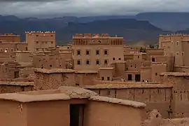 View of the Jbel Saghro above N'Kob | |
| Highest point | |
| Peak | Amalou n'Mansour |
| Elevation | 2,712 m (8,898 ft) |
| Coordinates | 31°9′0″N 5°39′0″W [1] |
| Dimensions | |
| Length | 320 km (200 mi) ENE/WSW |
| Width | 110 km (68 mi) NNW/SSE |
| Geography | |
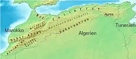 Location of the Jbel Saghro in the Maghreb area
| |
| Location | Morocco |
| Parent range | Anti-Atlas |
Geography
The Jbel Saghro is an eastern prolongation of the Anti-Atlas, separated from it by the valley of the Draâ. To the north of the range runs the valley of the Dadès, separating it from the massive High Atlas Range.
Saɣru in the Tamazight language means drought, an apt name considering that the Jbel Saghro is the driest mountain area of the whole Atlas Mountain System. Since it is located in the inland side of the greater range this massif does not benefit from the Atlantic Ocean winds that bring humidity to the Anti-Atlas ranges further to the west as well as other ocean-facing ranges further north. Annual rainfall is only 100 mm in the southern slopes and 300 mm at the summits. However, the desolation of the harsh landscapes of the massive dry mountains with the many areas of bare rock and the austere, lunar beauty does not leave anyone unimpressed. Therefore these mountain area is popular with trekkers and adventure-tourists. [3]
The highest summit of the range is 2,712 m high Amalou n'Mansour, located southeast of the village of Iknioun;[4] other notable peaks are 2,592 m high Jbel Kouaouch,[5][6] Jbel Afougal (2,196 m) and Jbel Amlal (2,447 m). One of the most important mountain passes of the range is the 2,283 m high Tizi n'Tazazert.
The Jbel Saghro area is a traditional region of the Aït Atta Berber tribe. It is sparsely inhabited, the only notable villages being N'Kob and Tazzarine.[7] There are cave paintings in certain areas of the range.[8]
Nomads
The Jbel Saghro area is home to nomad families who spend their winters in the region. They are semi-nomadic and migrate to Ait Bougemez (Paradise Valley) in the summer with their flocks of sheep and goats, using camels, mules and donkeys to transport their belongings. Their numbers are dwindling as they move to more permanent bases to find a less difficult life and ensure that their children are educated.[9]
Features
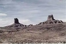 Landscape of the Bab n'Ali in the Jbel Saghro |
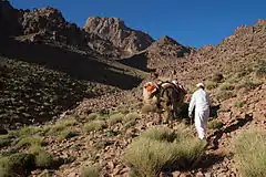 Mountain trekking in the Jbel Saghro. |

See also
References
- Google Earth
- Des Montagnes du Sarho aux dunes de Merzouga
- Sud-Maroc; Massif aux paysages lunaires
- Hervé Galley, Montagnes du Maroc: trekking et ski de randonnée, Éditions Olizane, 2004 (ISBN 2880863023)
- Djebel Kouaouch 2592 m Archived 2016-03-03 at the Wayback Machine
- Galleries - Marokko
- M. Aït Hamza, H. Popp, Randonnée culturelle dans le Djebel Saghro, Bayreuth, Rabat, 2004 (ISBN 3-9809181-3-0)
- Alain Rodrigue, L'art rupestre au Maroc : les sites principaux. p. 19
- Morrison, Alice (18 April 2019). My 1001 Nights. Simon and Schuster. pp. 171–198. ISBN 978-1-4711-7425-4.
External links
 Media related to Jbel Saghro at Wikimedia Commons
- Trekking across the Jbel Sarhro
- Travelling through the Jbel Sarhro by mule
| High Atlas |
|
|---|---|
| Middle Atlas |
|
| Anti-Atlas |
|
| Saharan Atlas |
|
| Rif |
|
| Other peaks & ranges |
|