Toubkal
Toubkal or Tubkal (Berber: ⵜⵓⴳⴳ ⴽⴰⵍ Tugg kal; Arabic: توبقال Tūbqāl) is a mountain peak in southwestern Morocco, located in the Toubkal National Park. At 4,167 metres (13,671 ft), it is the highest peak in the Atlas Mountains, Morocco, North Africa and the Amazigh World. Located 63 km (39 mi) south of the city of Marrakesh, and visible from it, Toubkal is an ultra prominent peak, the highest for over 2,000 km (1,200 mi). For climbers it is "the most popular mountain objective in the Atlas mountains".[3]
| Toubkal توبقال ⵜⵓⴳⴳ ⴽⴰⵍ | |
|---|---|
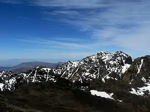 Tizi-n-Tubkal from the summit ridge | |
| Highest point | |
| Elevation | 4,167 m (13,671 ft) |
| Prominence | 3,755 m (12,320 ft) [1] Ranked 36th |
| Isolation | 2,078 km (1,291 mi) |
| Listing | Country high point List of Ultras of Africa |
| Coordinates | 31°03′33″N 7°54′57″W [1] |
| Geography | |
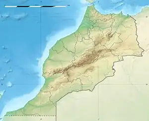 Toubkal 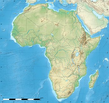 Toubkal Toubkal (Africa) | |
| Parent range | Atlas Mountains |
| Topo map | Toubkal Massif Map and Guide[2] |
| Climbing | |
| First ascent | 12 June 1923 by the Marquis de Segonzac, V. Berger, and H. Dolbeau |
| Easiest route | South cwm (hike in summer) |
Geography
Although much of the High Atlas consists of sedimentary rocks, the Toubkal massif is an area of volcanic rocks which have weathered into alpine crests, cut by deep, narrow valleys. To the south, the mountain drops steeply down for 1,800 metres (5,906 ft) to a small lake called Lac d'Ifni. To the west, the mountain's edge is marked by a pass, the Tizi n'Ouanoums at 3,664 metres (12,021 ft). From this pass, the mountain's W-S-W ridge rises up to Toubkal West, which forms a shoulder at 4,020 metres (13,189 ft) before continuing to the summit at 4,167 metres (13,671 ft).[3]
The north and western side of Toubkal drains down to the Mizane Valley, which has the passes of both Tizi n'Ouanoums and Tizi n'Ouagane at its head. Two hanging valleys on the western side of the mountain - the Ikhibi Nord and Ikhibi South provide ready access for trekkers and climbers to reach Toubkal's summit. At one time the northern valley provided the normal route of ascent, but the construction of a mountain hut by the French Alpine Club below Ikhibi Sud now encourages trekkers to ascent via the southern route instead.[3]
Access
Toubkal is popular with trekkers and ski mountaineers, but less so with climbers, despite its ease of access and sunny climate.[3] Trekkers usually approach the mountain from Marrakesh via the road-end village of Imlil. Qualified guides can be hired, as well as porters, to carry equipment and food supplies higher into the mountains. Since 2018, guides are now required even for the normal route, due to recent events on the trail (murder and deadly slips). Otherwise it is a moderate hike and navigation is not a problem.
The normal route starts with an easy walk to the village of Aroumd. Past Aroumd a floodplain is crossed and the route follows the left slope of the valley southwards. The valley bends to the east to the tiny settlement of Sidi Chamharouch, which has grown around a Muslim shrine. At Sidi Chamharouch, the path leads over the stream and runs steeply uphill to the right side of the Isougouane valley, which leads to two stone-built refuges (Refuge du Toubkal and Refuge Les Mouflons) that are often used as base camp at 3,207 m (10,522 ft). It is possible to buy good meals in the Refuge du Toubkal. Tents can be pitched near the refuges for a small charge & they offer five dorms for a total of 89 persons.
Routes
The first recorded ascent was on 12 June 1923 by the Marquis de Segonzac, Vincent Berger and Hubert Dolbeau, but the mountain may well have been climbed before that date.[4] Toubkal's height was measured the following year, and determined as being 4,165 metres (13,665 ft)[3] Nowadays measured at 4,167 metres, the summit is crowned with a large pyramidal metal trigonometric marker, and offers views taking in most of the Atlas and Little Atlas Mountains. It is possible to climb mountain Toubkal in two days - first day up to the refuge (around seven hours), second day to the summit (around four hours ascent, three hours descent) and back to Imlil (up to five hours).
In summer the mountains can be very dry, but are sometimes subject to storms. Although the temperature should remain above zero during the day, freezing conditions are possible over 3,500m. In winter the mountains are covered in snow and ice, and can be prone to avalanches. Skiing is possible as the snow can lie to considerable depth and cover many rocky slopes. Information about the state of the route can be obtained at Marrakesh tourist offices or at Imlil.
1) Ikhibi Sud (normal route). From the Toubkal refuge, a path crosses the stream, climbs a steep scree slope to the east and enters a hanging valley, then climbs another steep slope to reach a col (Tizi'n'Toubkal at 3,940m). At the col the route turns left (northwards) up easy slopes to the narrow summit crest of Jebel Toubkal.
The ascent during the summer (from May) is non-technical yet moderately difficult, only complicated by steep and slippery scree slopes and altitude sickness. Sturdy boots and proper (windproof) clothing are required, and trekking poles are helpful on the scree. An ice-axe may be needed on the remaining snowfields in the early summer. The ascent during the end of the winter and spring (February/March) is more difficult; crampons are necessary to ascend through the snow and - in some cases - ice. Ascent: 960 m (3,150 ft); 2.5 –3 hours.[3]
2) Ikhibi Nord Not as frequently ascended as Ikhibi Sud, but technically easier. The route starts some distance down the valley from the Toubkal refuge, and turns right (eastwards) to follow a track up through a hanging valley to a col on the north side of Toubkal. Ascent:1,000 metres (3,281 ft); 3–4 hours. The col also gives access to adjacent peaks of Imouzzer 4,010 m (13,156 ft) and Tibherine 3,887 m (12,753 ft)[3]
3) West-North-West Ridge (ONO Arete). (First ascent by J de Lepinay and party, 1936). Infrequently climbed, but a long and pleasant traverse containing many gaps and towers. Some difficulties can be avoided by means of an abseil. Grade III/IV; 7 hours.
On 17 December 2018, two trekkers, from Denmark and Norway, were murdered close to the foot of the trail in a terror-related attack.[5]

Gallery
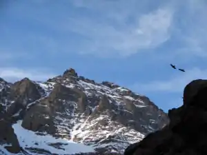 Birds soaring above the path to the summit
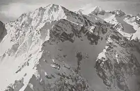 Jbel Toubkal in December 1930. Air photo taken by Swiss pilot and photographer Walter Mittelholzer.
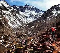 Hikers midway to the summit
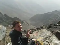 Hiker on Toubkal
See also
- Nearby villages of Asni, Ikkiss, Imlil and Tacheddirt.
References
- "Africa Ultra-Prominences" Peaklist.org. Retrieved 2012-01-14.
- Toubkal Massif Map and Guide (Map) (1st ed.). 1:160,000 with mountaineering information. High Atlas Mountains. Cartography by EWP. EWP and West Col Productions. 2008. ISBN 978-0-906227-98-5.
- Hamish Brown (1998). "Jebel Toubkal". In Salkeld, Audrey (ed.). World mountaineering : the world's great mountains by the world's great mountaineers. Mitchell Beazley. pp. 272–275. ISBN 1845331427.
- Robin G. Collomb, Atlas Mountains, Goring: West Col, 1980
- O'Grady, Siobhán. "Two tourists killed in Morocco — one of them beheaded — in likely terrorist attack". The Washington Post. The Washington Post. Retrieved 22 December 2018.
External links
| Wikimedia Commons has media related to Jbel Toubkal. |
| Wikivoyage has a travel guide for Jebel Toubkal. |
- Routes up Mount Toubkal
- What to wear on Mount Toubkal in winter?
- Summitpost.org page about Jbel Toubkal
- Photo Gallery of Jebel Toubkal and the High Atlas
- Refuge information
- Useful information on climbing Toubkal
| High Atlas |
|
|---|---|
| Middle Atlas |
|
| Anti-Atlas |
|
| Saharan Atlas |
|
| Rif |
|
| Other peaks & ranges |
|