Jiroft
Jiroft (Persian: جيرفت, also Romanized as Jīroft; formerly, Sabzāwārān, Sabzevārān, Sabzevārān-e Jiroft, and Sabzvārān)[2] is a city and capital of Jiroft County, Kerman Province, Iran. At the 2006 census, its population was 95,031, in 19,926 families.[3] It is located 230 kilometres (140 mi) south of the city of Kerman, and 1,375 kilometres (854 mi) south of Tehran along Road 91. In the past it was also called Sabzevaran, and on account of its being very fertile land it is famous as Hend-e-Koochak (the little India).
Jiroft
جيرفت | |
|---|---|
City | |
 | |
 Jiroft | |
| Coordinates: 28°40′41″N 57°44′26″E | |
| Country | |
| Province | Kerman |
| County | Jiroft |
| Bakhsh | Central |
| Population (2016 Census) | |
| • Urban | 130,429[1] |
| Time zone | UTC+3:30 (IRST) |
| • Summer (DST) | UTC+4:30 (IRDT) |
Jiroft is located in a vast plain, Halil River, on the southern outskirts of the Jebal Barez mountain chain, surrounded by two rivers. The mean elevation of the city is about 650 metres (2,130 ft) above sea level. The weather of the city is sweltering in summer – it is one of the hottest places in Iran – but temperatures are moderate in winter.
There is a large dam (Jiroft Dam) upstream the city (40 km North-East of Jiroft) on the Halil River (Halilrood). It is under operation since 1992. Having a reservoir of more than 410 million cubic meters of water, irrigates 14200 hectares of the downstream and generates electricity.[4]
The city is served by Jiroft Airport, located several kilometres to the northwest.
Jiroft culture
A "Jiroft culture"[5] has been postulated as an early Bronze Age (late 3rd millennium BC) archaeological culture, located in the territory of present-day Sistan and Kermān Provinces of Iran. The hypothesis is based on a collection of artifacts that were confiscated in Iran and accepted by many to have derived from the Jiroft area in south central Iran, reported by online Iranian news services, beginning in 2001.
The proposed type site is Konar Sandal, near Jiroft in the Halil River area. Other significant sites associated with the culture include; Shahr-e Sukhteh (Burnt City), Tepe Bampur, Espiedej, Shahdad, Tal-i-Iblis and Tepe Yahya.
The local language of Jiroft is Jirofti, also designated as Garmsiri. Garmsiri is a continuum of closely related dialects extending from the Halilrud river valley in the north down to the Strait of Hormuz in the south.[6]
Gallery
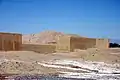 Ruins in Jiroft County.
 Jiroft Map
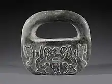 Master of animals in chlorite, Jiroft, Kerman ca. 2500 BC, Bronze Age I, National Museum of Iran
References
- "Statistical Center of Iran > Home". www.amar.org.ir.
- Jiroft can be found at GEOnet Names Server, at this link, by opening the Advanced Search box, entering "-3068011" in the "Unique Feature Id" form, and clicking on "Search Database".
- "Census of the Islamic Republic of Iran, 1385 (2006)". Islamic Republic of Iran. Archived from the original (Excel) on 2011-11-11.
- Abdolreza Bahremand, 1997, MSc thesis, Flood routing through the Jiroft Dam reservoir, Tehran University, Iran.
- Oscar White Muscarella, Jiroft (2008), in: Encyclopedia Iranica. "For archeological accuracy the terms "Jiroft" or "Jiroft culture" employed to define a specific ancient Iranian culture and its artifacts should only be cited within quotation marks. All the artifacts known to date that are accorded the Jiroft label have not been excavated; they have in fact been plundered."
- Habib Borjian, “KERMAN xvi. LANGUAGES,” Encyclopædia Iranica, XVI/3, pp. 301-315, available online at http://www.iranicaonline.org/articles/kerman-16-languages
External links
![]() Media related to Jiroft at Wikimedia Commons
Media related to Jiroft at Wikimedia Commons
- jiroft city website اطلاعات در مورد جیرفت
- مستند تمدنی گم شده lost civilization documentary with Roger Matthews (archaeologist) on YouTube
| Capital | 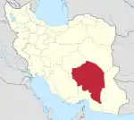 | |
|---|---|---|
| Counties and cities | ||
| Sights |
| |
| Places | ||
