Rafsanjan
Rafsanjan (Persian: رفسنجان, also Romanized as Rafsanjān and Rafsinjān; also known as Bahrāmābād)[2] is a city and capital of Rafsanjan County, Kerman Province, Iran. At the 2006 census, its population was 136,388, in 33,489 families. Rafsanjan is the biggest producer of pistachios in the world. Also one of the biggest cooper mine in the world is located there too. In addition the biggest and oldest house of the world is located there. Many famous people were born in Rafsanjan: Mirza Reza Kermani, Ali Akbar Hashemi,Adel Ferdosipour and etc.[3]
Rafsanjan
رفسنجان | |
|---|---|
City | |
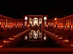
 Haj Agha Ali House in Rafsanjan | |
 Rafsanjan | |
| Coordinates: 30°24′24″N 55°59′38″E | |
| Country | |
| Province | Kerman |
| County | Rafsanjan |
| part | Central |
| Population (2016 Census) | |
| • Urban | 161,909 [1] |
| Time zone | UTC+03:30 (IRST) |
| • Summer (DST) | UTC+04:30 (IRDT) |
It is Iran's center of pistachio cultivation. It had an estimated population of 134,848 in 2005.[4]
Rafsanjan is also a major center of carpet production even though the rugs are sold as Kermani rugs rather than Rafsanjani ones. Another large employer is the nearby Sarcheshmeh copper mines.
Geography
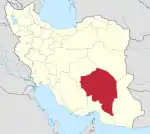
Rafsanjan is located in south part of the Lut desert, in north-west of Kerman province. The longitude of this city is 56 degrees east and the latitude is 30 degrees south. The Average distance between Kerman and this city is 110 km (68 mi). The city has an airport and railway (Tehran-Bandar Abbas route). Moreover, the altitude is 1,460 m (4,790 ft) and the land-measurement is approximately 10,687 km (6,641 mi). North part of Rafsanjan has a common frontier with Bafgh and Zarand; south part is neighboring with Bardsir and on west side with Anar and Shahre-Babak; finally east side of this beautiful city is neighboring with Kerman and Zarand. Rafsanjan has two seasonal rivers named as Shour and Giouderi. The mountains in the area are part of Zagros range, and Sarcheshmeh and Davaran are the most famous.
History
About the origin and creation of this city there are a lot of stories. At the period of Qajar kingdom and on Naser-Aldin-Shah (the king of Iran), Rafsanjan was named az “Anas” and was part of Fars province; after a while it came under the control of Kerman’s government. In the history, Rafsanjan has been named as a significant city due to being on the crossroad between Kerman and Yazd. At the end of Safavieh kingdom, Afghans attacked this city and caused disaster and catastrophe. The low rate of prosperity after mentioned attack was stretched until Qajar’s kingdom and the city was almost ruined until that time. At 1787 Agha Mohammad Khan Qajar attacked to Rafanjan and people decided to acquiesce in order to end the war, so he left the city without killing and death and violence. At 1866 Ebrahim Khan Zahiradole (the government of Kerman) ordered to reshape and rebuild the city. Buildings start to construct and the situation started to improve. At 1913 Amir Mofkhem Bakhtiari ordered to build a strong wall around the city which part of ruins still remain today. This step caused importance and accredit to the city. For the first time at 1938, crossroad was built at the city, which is named as Emem Khomeyni, Enghelsb and Shohada these days. Rafsanjan was also an important city because of being one of the biggest producers of cotton earlier on time. Due to high quality of this product, it was exported to India and Russia. At 1945 Rafsanjan changed to township. These days Rafsanjan is one of the most important and crowded cities of Kerman and has an undeniable role in the economy of state and country. Mines and pistachios are well known not only in Iran, but all around the world.
Climate
Rafsanjan has cold and freezing winters as well as hot and dried summers. This city is located in the central part of Iran and this region is desert. The weather is hot in summer and cold in winter, days are warm and nights are cold in general. The average amount of rainfall is 100 mm (3.9 in) annually.
Flora and fauna
Wild plantations and trees include common fig and almonds. Wild animals which are living in mountainous areas are goats, ewes, gazelles, wolves, hyenas, wildcats and some species of birds like pigeons, eagles and partridges.
Transport
Rafsanjan is located in the main road of Kerman-Yazd. The distances between Rafsanjan and other cities are: 12 km (7.5 mi) to Bardsir, 140 km (87 mi) to Sirjan, 130 km (81 mi) to Shahre-Babak, 90 km (56 mi) to Anar, 75 km (47 mi) to Zarand, 185 km (115 mi) to Bafgh and 230 km (140 mi) to Yazd. Local people use both public and private vehicles, however private ones are more popular among citizens than public vehicles. Rafsanjan also has buses, railways and an airport to go to other cities and provinces.
Population
The average population of Rafsanjan in different years have been as following: in 2006: 139,219; in 2011: 151,420; in 2016: 161,909.
Notable Rafsanjanis
- Former President of Iran Hashemi Rafsanjani was born in Nough, near Rafsanjan
- Former Minister of Culture and Islamic Guidance, Mohammad Hosseini was born in Koshkouyeh near Rafsanjan
- Seyyed Hossein Marashi, former Iranian Vice-President of Cultural Heritage and Tourism, was born in Koshkouyeh near Rafsanjan.
- Ali Samereh, Iranian football player
- Mark Amin, vice president of Lions Gate Entertainment production company.
Colleges and universities
Sport
Football club Mes Rafsanjan F.C. is based in the city.
Sustainable development
According to the UN-HABITAT Program, Agenda 21 that is the global agenda for sustainable development, is formulated for cities as well as countries. "The Local Agenda for Sustainable Development" is seeking a strategy aimed at managing the living space and urban development. It prepares the ground for the development of "indigenous habitat knowledge" and maintains that the potentials of any given environment are different from those of others and the knowledge that is acquired in an environment is not capable of addressing the issues of other environments. Any habitat calls for real, healthy, manageable and last but not least its particular development system. In such a system, most of the potentials of the region should turn into opportunities for its development. This program is one of the most precise methods, is harmonious with the development context, finds the required resources and evaluates and uses them for the development purposes. Local Agenda 21 for Rafsanjan is aimed at the development of the city of Rafsanjan. The development priorities, infrastructure and necessary projects are determined by the citizens and city managers.
References
- https://www.amar.org.ir/english
- Rafsanjan can be found at GEOnet Names Server, at this link, by opening the Advanced Search box, entering "-3080584" in the "Unique Feature Id" form, and clicking on "Search Database".
- "Census of the Islamic Republic of Iran, 1385 (2006)". Islamic Republic of Iran. Archived from the original (Excel) on 2011-11-11.
- "2005 population estimates for cities in Iran". namecensus.com. 2004–2007.
