Juglot
Juglot or Jaglot (formerly Sai[1]) is a city in Gilgit District, Pakistan, and is situated 45 km south east of Gilgit on the Karakoram Highway. It is located at the junction of three mightiest mountain ranges, the Karakorum, Hindukush, and Himalayas.It is also the junction where the ways of Gilgit and Skardu splits in different directions. The road to Skardu branches off about six kilometers towards Gilgit.[2]
Juglot | |
|---|---|
City | |
 Juglot | |
| Coordinates: 35°41′06″N 74°37′26″E | |
| Country | |
| Region | Gilgit-Baltistan |
| Division | Gilgit Division |
| District | Gilgit District |
| Elevation | 1,988 m (6,522 ft) |
| Population | 27,000 |
| Time zone | UTC+5 (PST) |
Geography
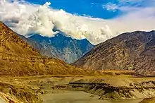
Jaglot is at the mouth of Sai Nala as it joins the Indus River on its right. Across the Indus river on its left bank is the large village of Bunji. In the 19th century, a ferry service used to run between Jaglot (then called "Sai") and Bunji, which provided the only means of communication between Gilgit and Kashmir.[1] In 1893, a suspension bridge called Partab Bridge was constructed a little upstream, which provided easier communication.
About 3 miles above the mouth of Sai Nala, another mountain torrent joins it from the left. This and the Sai Nala provide several fertile plains, on which were settled about a dozen hamlets, all of which have now merged into the village of Jaglot.
History
Historically, Juglot was strategically important as it lay along the route linking British India to China via Kashmir. Bunji, the historical garrison of the army of the Maharaja of Kashmir, is situated across the River Indus. The struggle for Kashmir's independence from the Sikh Maharaja of Kashmir also originated in Juglot.
Even today, Juglot is the most important logistic base for the Pakistan Army. It gained this importance from the 1984 war in Siachen, which became the highest battleground in the world. Much of the development of Juglot is a result of the Army's presence.
Resources
Juglot is located in a fertile valley with rich natural resources. It is one of the business hubs of the Northern Areas because all six districts have access through Juglot. The town also contains the largest oil, wheat and flour depots for the Northern Areas. It has independent power generation facilities and sufficient electric power to attract a number of flour mills and marble plants. Even artisanal gold panning in the Indus river is still carried out by a tribe known as the Soniwals (gold hunters).
Villages
Juglot contains fifteen villages which include:[1]
References
- Gazetteer of Kashmir and Ladak, 1890, p.711.
- "Jaglote: where three empires meet - The Express Tribune". The Express Tribune. 2016-10-07. Retrieved 2017-10-10.
- Gazetteer of Kashmir and Ladak, 1890, p.232.
- Gazetteer of Kashmir and Ladak, 1890, p.250.
