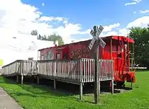
Junction City, Kentucky
Junction City is a home rule-class city[4] in Boyle County on its border with Lincoln County in the U.S. state of Kentucky. Junction City's population was 2,241 at the 2010 U.S. census.[5] It is part of the Danville Micropolitan Statistical Area.
Junction City, Kentucky | |
|---|---|
 Junction City | |
 Location of Junction City in Boyle County, Kentucky. | |
| Coordinates: 37°35′7″N 84°47′19″W | |
| Country | United States |
| State | Kentucky |
| Counties | Boyle |
| Incorporated | April 8, 1882[1] |
| Named for | the L&N and Cincinnati Southern railroads |
| Government | |
| • Type | Mayor-council government |
| Area | |
| • Total | 2.00 sq mi (5.18 km2) |
| • Land | 1.99 sq mi (5.17 km2) |
| • Water | 0.01 sq mi (0.01 km2) |
| Elevation | 991 ft (302 m) |
| Population (2010) | |
| • Total | 2,241 |
| • Estimate (2019)[3] | 2,306 |
| • Density | 1,156.47/sq mi (446.45/km2) |
| Time zone | UTC-5 (Eastern (EST)) |
| • Summer (DST) | UTC-4 (EDT) |
| ZIP code | 40440 |
| Area code(s) | 859 |
| FIPS code | 21-41338 |
| GNIS feature ID | 0495551 |
| Website | jcky |
History
Junction City began when the Louisville and Nashville Railroad reached the area. It was originally known as "Goresburg" for the proprietors of the Gore Hotel. The Gore post office opened in 1880, and was renamed Goresburg in 1882. The town was renamed "Junction City" when the Cincinnati Southern Railway reached town later that year, its tracks intersecting those of the L&N. The city was formally incorporated April 8, 1882, by the state assembly.[1] The L&N station there was known as "Danville Junction" for its proximity to the larger city of Danville.
The southeastern part of Junction City was once the separate town of Shelby City, incorporated in 1867, and named for Kentucky's first governor Isaac Shelby, who lived and was buried nearby. This community's separate post office was known as "South Danville" when it was established April 26, 1866, renamed Shelby City the next year (the eastern portion of Junction City is still known as Shelby City), and closed in 1926. It was also known as "Briartown" and its L&N station was called "Danville Station". The tomb of Kentucky's first governor, Isaac Shelby, and his homestead Traveler's Rest, is located across the Lincoln County line, just south of this part of town.[6]
Geography
Junction City is located at 37°35′07″N 84°47′19″W. According to the United States Census Bureau, the city has a total area of 1.9 square miles (4.8 km2), all land.[7] The city lies in a broad valley south of Danville, and just north of the border between Boyle and Lincoln counties. Much of Junction City is concentrated along Shelby Street between the Cincinnati Southern tracks on the west and U.S. Route 127 on the east. The part of town east of US 127 is known as "Shelby City." Kentucky Route 37 and Kentucky Route 300 intersect in northwestern Junction City.
Demographics
| Historical population | |||
|---|---|---|---|
| Census | Pop. | %± | |
| 1880 | 174 | — | |
| 1890 | 648 | 272.4% | |
| 1900 | 817 | 26.1% | |
| 1910 | 747 | −8.6% | |
| 1920 | 722 | −3.3% | |
| 1930 | 781 | 8.2% | |
| 1940 | 694 | −11.1% | |
| 1950 | 988 | 42.4% | |
| 1960 | 1,047 | 6.0% | |
| 1970 | 1,046 | −0.1% | |
| 1980 | 2,045 | 95.5% | |
| 1990 | 1,983 | −3.0% | |
| 2000 | 2,184 | 10.1% | |
| 2010 | 2,241 | 2.6% | |
| 2019 (est.) | 2,306 | [3] | 2.9% |
| U.S. Decennial Census[8] | |||
As of the census[9] of 2000, there were 2,184 people, 876 households, and 617 families residing in the city. The population density was 1,088.3 per square mile (420.2/km2). There were 945 housing units at an average density of 470.9 per square mile (181.8/km2). The racial makeup of the city was 97.53% White, 1.05% African American, 0.09% Native American, 0.27% Asian, 0.73% from other races, and 0.32% from two or more races. Hispanic or Latino of any race were 3.85% of the population.
There were 876 households, out of which 34.8% had children under the age of 18 living with them, 47.4% were married couples living together, 18.8% had a female householder with no husband present, and 29.5% were non-families. 25.6% of all households were made up of individuals, and 12.3% had someone living alone who was 65 years of age or older. The average household size was 2.49 and the average family size was 2.93.
27.3% of the population was under the age of 18, 8.7% from 18 to 24, 30.1% from 25 to 44, 21.8% from 45 to 64, and 12.0% who were 65 years of age or older. The median age was 34 years. For every 100 females, there were 87.3 males. For every 100 females age 18 and over, there were 83.8 males.
The median income for a household in the city was US $29,569, and the median income for a family was $32,609. Males had a median income of $25,700 versus $21,688 for females. The per capita income for the city was $13,258. About 14.5% of families and 16.9% of the population were below the poverty line, including 19.5% of those under age 18 and 20.4% of those age 65 or over.
References
- Commonwealth of Kentucky. Office of the Secretary of State. Land Office. "Junction City, Kentucky". Accessed 1 August 2013.
- "2019 U.S. Gazetteer Files". United States Census Bureau. Retrieved July 24, 2020.
- "Population and Housing Unit Estimates". United States Census Bureau. May 24, 2020. Retrieved May 27, 2020.
- "Summary and Reference Guide to House Bill 331 City Classification Reform" (PDF). Kentucky League of Cities. Retrieved December 30, 2014.
- "Profile of General Population and Housing Characteristics: 2010 Demographic Profile Data (DP-1): Junction City city, Kentucky". United States Census Bureau. Retrieved July 30, 2012.
- "Kentucky Atlas & Gazetteer". Retrieved 2008-11-01.
- "Geographic Identifiers: 2010 Demographic Profile Data (G001): Junction City city, Kentucky". United States Census Bureau. Retrieved July 30, 2012.
- "Census of Population and Housing". Census.gov. Retrieved June 4, 2015.
- "U.S. Census website". United States Census Bureau. Retrieved 2008-01-31.
External links
| Wikimedia Commons has media related to Junction City, Kentucky. |
Municipalities and communities of Boyle County, Kentucky, United States | ||
|---|---|---|
| Cities | 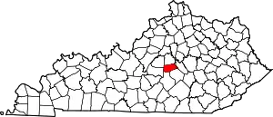 Location of Boyle County, Kentucky | |
| Unincorporated communities | ||
| ||
Municipalities and communities of Lincoln County, Kentucky, United States | ||
|---|---|---|
| Cities | 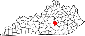 Location of Lincoln County, Kentucky | |
| CDP | ||
| Unincorporated communities | ||
| Footnotes | ‡This populated place also has portions in an adjacent county | |
| ||
| Authority control |
|---|