Lincoln County, Kentucky
Lincoln County is a county located in the U.S. state of Kentucky. As of the 2010 census, the population was 24,742.[1] Its county seat is Stanford.[2] Lincoln is a prohibition or "dry county."
Lincoln County | |
|---|---|
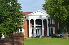
.jpg.webp) Lincoln County courthouse in Stanford | |
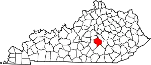 Location within the U.S. state of Kentucky | |
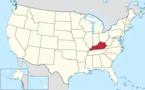 Kentucky's location within the U.S. | |
| Coordinates: 37°28′N 84°40′W | |
| Country | |
| State | |
| Founded | 1780 |
| Named for | Benjamin Lincoln |
| Seat | Stanford |
| Largest city | Stanford |
| Area | |
| • Total | 337 sq mi (870 km2) |
| • Land | 334 sq mi (870 km2) |
| • Water | 2.5 sq mi (6 km2) 0.7%% |
| Population | |
| • Estimate (2018) | 24,644 |
| • Density | 74/sq mi (29/km2) |
| Time zone | UTC−5 (Eastern) |
| • Summer (DST) | UTC−4 (EDT) |
| Congressional district | 5th |
| Website | www |
Lincoln County is part of the Danville, KY Micropolitan Statistical Area.
History
Lincoln County—originally Lincoln County, Virginia—was established by the Virginia General Assembly in June 1780, and named in honor of Revolutionary War general Benjamin Lincoln.[3][4] It was one of three counties formed out of Virginia's Kentucky County (The other two were Fayette and Jefferson), and is one of Kentucky's nine original counties.
The county's original seat was at Harrodsburg; but in 1785, Lincoln County was partitioned, and Harrodsburg became the seat of the new Mercer County. Afterward, Stanford became Lincoln County's permanent seat.

Geography
According to the U.S. Census Bureau, the county has a total area of 337 square miles (870 km2), of which 334 square miles (870 km2) is land and 2.5 square miles (6.5 km2) (0.7%) is water.[5]
Lincoln County lies astride the southern part of the ring of Knobs, which separate the Bluegrass region from the Eastern Pennyroyal region, the Lincoln County part of which includes the source and headwaters of the Green River.
Adjacent counties
- Boyle County (northwest)
- Garrard County (northeast)
- Rockcastle County (east)
- Pulaski County (south)
- Casey County (west)
Demographics
| Historical population | |||
|---|---|---|---|
| Census | Pop. | %± | |
| 1790 | 6,548 | — | |
| 1800 | 8,621 | 31.7% | |
| 1810 | 8,676 | 0.6% | |
| 1820 | 9,979 | 15.0% | |
| 1830 | 11,002 | 10.3% | |
| 1840 | 10,187 | −7.4% | |
| 1850 | 10,093 | −0.9% | |
| 1860 | 10,647 | 5.5% | |
| 1870 | 10,947 | 2.8% | |
| 1880 | 15,080 | 37.8% | |
| 1890 | 15,962 | 5.8% | |
| 1900 | 17,059 | 6.9% | |
| 1910 | 17,897 | 4.9% | |
| 1920 | 16,481 | −7.9% | |
| 1930 | 17,687 | 7.3% | |
| 1940 | 19,859 | 12.3% | |
| 1950 | 18,668 | −6.0% | |
| 1960 | 16,503 | −11.6% | |
| 1970 | 16,663 | 1.0% | |
| 1980 | 19,053 | 14.3% | |
| 1990 | 20,045 | 5.2% | |
| 2000 | 23,361 | 16.5% | |
| 2010 | 24,742 | 5.9% | |
| 2018 (est.) | 24,644 | [6] | −0.4% |
| U.S. Decennial Census[7] 1790-1960[8] 1900-1990[9] 1990-2000[10] 2010-2013[1] | |||
As of the census[11] of 2000, there were 23,361 people, 9,206 households, and 6,729 families residing in the county. The population density was 70 per square mile (27/km2). There were 10,127 housing units at an average density of 30 per square mile (12/km2). The racial makeup of the county was 96.12% White, 2.53% Black or African American, 0.15% Native American, 0.10% Asian, 0.38% from other races, and 0.72% from two or more races. 0.89% of the population were Hispanic or Latino of any race.
There were 9,206 households, out of which 33.70% had children under the age of 18 living with them, 58.60% were married couples living together, 10.30% had a female householder with no husband present, and 26.90% were non-families. 23.60% of all households were made up of individuals, and 10.50% had someone living alone who was 65 years of age or older. The average household size was 2.51 and the average family size was 2.95.
By age, 25.70% of the population was under 18, 8.40% from 18 to 24, 29.80% from 25 to 44, 23.10% from 45 to 64, and 13.10% were 65 or older. The median age was 36 years. For every 100 females, there were 96.30 males. For every 100 females age 18 and over, there were 94.10 males.
The median income for a household in the county was $26,542, and the median income for a family was $32,284. Males had a median income of $26,395 versus $20,517 for females. The per capita income for the county was $13,602. About 16.40% of families and 21.10% of the population were below the poverty line, including 27.10% of those under age 18 and 22.90% of those age 65 or over.
Politics
Lincoln County has been reliably Republican for several decades now, last voting for a Democratic candidate for President in 1976. In 2020, Donald Trump won the highest share of the vote ever for a presidential candidate in the county, garnering 77.8% of the vote.
| Year | Republican | Democratic | Third parties |
|---|---|---|---|
| 2020 | 77.8% 8,484 | 20.6% 2,247 | 1.6% 170 |
| 2016 | 76.8% 7,338 | 19.5% 1,865 | 3.7% 358 |
| 2012 | 70.1% 6,416 | 28.2% 2,582 | 1.7% 154 |
| 2008 | 68.6% 6,273 | 30.1% 2,752 | 1.4% 126 |
| 2004 | 67.7% 5,996 | 31.6% 2,796 | 0.8% 71 |
| 2000 | 63.1% 4,795 | 35.3% 2,678 | 1.6% 124 |
| 1996 | 49.2% 3,006 | 41.7% 2,550 | 9.1% 555 |
| 1992 | 44.1% 2,624 | 42.6% 2,532 | 13.3% 790 |
| 1988 | 56.6% 3,530 | 43.0% 2,677 | 0.4% 25 |
| 1984 | 61.3% 3,996 | 38.3% 2,498 | 0.4% 28 |
| 1980 | 49.7% 3,034 | 49.0% 2,991 | 1.3% 80 |
| 1976 | 45.5% 2,694 | 54.0% 3,198 | 0.6% 33 |
| 1972 | 65.0% 3,623 | 33.8% 1,882 | 1.2% 66 |
| 1968 | 47.5% 2,591 | 31.8% 1,736 | 20.8% 1,134 |
| 1964 | 37.1% 1,958 | 62.7% 3,307 | 0.2% 12 |
| 1960 | 61.2% 3,747 | 38.9% 2,381 | 0.0% 0 |
| 1956 | 54.3% 3,535 | 45.4% 2,953 | 0.3% 22 |
| 1952 | 52.1% 3,186 | 47.6% 2,910 | 0.3% 18 |
| 1948 | 45.4% 2,593 | 51.1% 2,920 | 3.5% 202 |
| 1944 | 47.2% 2,793 | 52.1% 3,087 | 0.7% 42 |
| 1940 | 45.6% 3,090 | 53.9% 3,657 | 0.5% 36 |
| 1936 | 47.0% 3,211 | 52.4% 3,575 | 0.6% 40 |
| 1932 | 39.8% 3,063 | 59.4% 4,574 | 0.8% 58 |
| 1928 | 62.7% 3,903 | 37.2% 2,314 | 0.2% 10 |
| 1924 | 46.7% 2,935 | 49.3% 3,100 | 4.0% 254 |
| 1920 | 49.0% 3,710 | 50.1% 3,787 | 0.9% 69 |
| 1916 | 45.0% 1,868 | 53.2% 2,212 | 1.8% 76 |
| 1912 | 22.5% 842 | 49.9% 1,863 | 27.6% 1,031 |
Communities
Cities
- Crab Orchard
- Eubank (mostly in Pulaski County)
- Hustonville
- McKinney, Kentucky
- Stanford (county seat)
- Waynesburg, Kentucky
Census-designated place
Other unincorporated places
- Kings Mountain
- Waynesburg
- Highland
- Preachersville
- Moreland
- Ottenheim
References
- "State & County QuickFacts". United States Census Bureau. Archived from the original on June 6, 2011. Retrieved March 6, 2014.
- "Find a County". National Association of Counties. Retrieved 2011-06-07.
- The Register of the Kentucky State Historical Society, Volume 1. Kentucky State Historical Society. 1903. pp. 36.
- Collins, Lewis (1877). History of Kentucky. p. 468.
- "2010 Census Gazetteer Files". United States Census Bureau. August 22, 2012. Archived from the original on August 12, 2014. Retrieved August 17, 2014.
- "Population and Housing Unit Estimates". Retrieved July 29, 2019.
- "U.S. Decennial Census". United States Census Bureau. Retrieved August 17, 2014.
- "Historical Census Browser". University of Virginia Library. Retrieved August 17, 2014.
- "Population of Counties by Decennial Census: 1900 to 1990". United States Census Bureau. Retrieved August 17, 2014.
- "Census 2000 PHC-T-4. Ranking Tables for Counties: 1990 and 2000" (PDF). United States Census Bureau. Retrieved August 17, 2014.
- "U.S. Census website". United States Census Bureau. Retrieved 2008-01-31.
- Leip, David. "Dave Leip's Atlas of U.S. Presidential Elections". uselectionatlas.org. Retrieved 2018-07-03.
External links
| Wikimedia Commons has media related to Lincoln County, Kentucky. |
Municipalities and communities of Lincoln County, Kentucky, United States | ||
|---|---|---|
| Cities | Location of Lincoln County, Kentucky | |
| CDP | ||
| Unincorporated communities | ||
| Footnotes | ‡This populated place also has portions in an adjacent county | |
| ||
| Authority control |
|---|