Königsberg, Bavaria
Königsberg in Bayern is a town in the Haßberge district, in Lower Franconia, Bavaria, Germany. It is situated 7 km northeast of Haßfurt, and 31 km northwest of Bamberg.
Königsberg in Bayern | |
|---|---|
 Aerial view of the old town of Königsberg | |
 Coat of arms | |
Location of Königsberg in Bayern within Haßberge district  | |
 Königsberg in Bayern  Königsberg in Bayern | |
| Coordinates: 50°4′40″N 10°34′00″E | |
| Country | Germany |
| State | Bavaria |
| Admin. region | Unterfranken |
| District | Haßberge |
| Subdivisions | 10 Ortsteile |
| Government | |
| • Mayor | Claus Bittenbrünn (FW) |
| Area | |
| • Total | 61.86 km2 (23.88 sq mi) |
| Elevation | 280 m (920 ft) |
| Population (2019-12-31)[1] | |
| • Total | 3,588 |
| • Density | 58/km2 (150/sq mi) |
| Time zone | UTC+01:00 (CET) |
| • Summer (DST) | UTC+02:00 (CEST) |
| Postal codes | 97486 |
| Dialling codes | 09525 |
| Vehicle registration | HAS |
| Website | www.koenigsberg.de |
It was an exclave of Saxe-Coburg and Gotha until 1918, after having been a part of Saxe-Hildburghausen.
Notable people
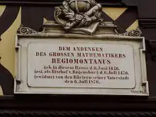
Plaque at the birthplace of Regiomontanus
- Johannes Müller alias Regiomontanus (6 June 1436 - 6 July 1476), a famous mathematician and astronomer
- Johannes Marcellus (1510 - 25 December 1552), a philologist and poet, also called Regiomontanus
- Friedrich Heinrich von Seckendorff, Imperial Fieldmarschall and Diplomat
- Wolfgang Carl Briegel, composer
References
- "Tabellenblatt "Daten 2", Statistischer Bericht A1200C 202041 Einwohnerzahlen der Gemeinden, Kreise und Regierungsbezirke". Bayerisches Landesamt für Statistik und Datenverarbeitung (in German). July 2020.
Towns and municipalities in Haßberge (district) | ||
|---|---|---|
Coat of Arms of Haßberge district | ||
| Authority control |
|---|
This article is issued from Wikipedia. The text is licensed under Creative Commons - Attribution - Sharealike. Additional terms may apply for the media files.