Kōya, Wakayama
Kōya (高野町, Kōya-chō) is a town located on a plateau atop Mt. Koya in Ito District, Wakayama Prefecture, Japan. The town is known as the headquarters of the Shingon sect of Japanese Buddhism.
Kōya
高野町 | |||||||||||
|---|---|---|---|---|---|---|---|---|---|---|---|
Town | |||||||||||
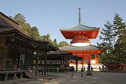 View of sightseeing of Mount Koya spot, with one of UNESCO World Heritage site | |||||||||||
 Flag | |||||||||||
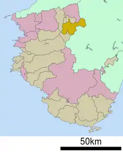 Location of Kōya in Wakayama Prefecture | |||||||||||
 Kōya Location in Japan | |||||||||||
| Coordinates: 34°13′N 135°35′E | |||||||||||
| Country | Japan | ||||||||||
| Region | Kansai | ||||||||||
| Prefecture | Wakayama Prefecture | ||||||||||
| District | Ito | ||||||||||
| Government | |||||||||||
| • Mayor | Takeji Kise (since May 2010) | ||||||||||
| Area | |||||||||||
| • Total | 137.08 km2 (52.93 sq mi) | ||||||||||
| Population (October 1, 2016) | |||||||||||
| • Total | 3,279 | ||||||||||
| • Density | 24/km2 (62/sq mi) | ||||||||||
| Time zone | UTC+09:00 (JST) | ||||||||||
| City hall address | Oji Koyasan 636, Koya Town, Ito District, Wakayama Prefecture (和歌山県伊都郡高野町大字高野山636) 648-0281 | ||||||||||
| Website | www | ||||||||||
| |||||||||||
As of October 1, 2016, the town has an estimated population of 3,279 and a density of 24 persons per km². The total area is 137.08 km².
Geography
Transportation
Railway
External links
 Media related to Kōya, Wakayama at Wikimedia Commons
- Kōya official website (in Japanese)
| Authority control |
|---|
| Core city | Flag of Wakayama Prefecture | |
|---|---|---|
| Cities | ||
| Districts | ||
This article is issued from Wikipedia. The text is licensed under Creative Commons - Attribution - Sharealike. Additional terms may apply for the media files.