Wakayama Prefecture
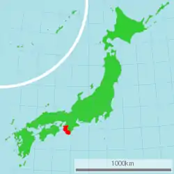
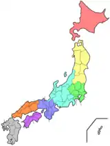
Wakayama Prefecture (和歌山県, Wakayama-ken) is a prefecture of Japan located in the Kansai region of Honshu.[1](p1026) Wakayama Prefecture has a population of 944,320 (as of 1 October 2017) and has a geographic area of 4,724 square kilometres (1,824 sq mi). Wakayama Prefecture borders Osaka Prefecture to the north, and Mie Prefecture and Nara Prefecture to the northeast.
Wakayama Prefecture
和歌山県 | |||||||||||||
|---|---|---|---|---|---|---|---|---|---|---|---|---|---|
| Japanese transcription(s) | |||||||||||||
| • Japanese | 和歌山県 | ||||||||||||
| • Rōmaji | Wakayama-ken | ||||||||||||
 Flag  Symbol | |||||||||||||
 | |||||||||||||
| Country | Japan | ||||||||||||
| Region | Kansai | ||||||||||||
| Island | Honshū | ||||||||||||
| Capital | Wakayama (city) | ||||||||||||
| Subdivisions | Districts: 6, Municipalities: 30 | ||||||||||||
| Government | |||||||||||||
| • Governor | Yoshinobu Nisaka | ||||||||||||
| Area | |||||||||||||
| • Total | 4,724.69 km2 (1,824.21 sq mi) | ||||||||||||
| Area rank | 30th | ||||||||||||
| Population (1 October 2017) | |||||||||||||
| • Total | 944,320 | ||||||||||||
| • Rank | 39th | ||||||||||||
| • Density | 199.87/km2 (517.7/sq mi) | ||||||||||||
| ISO 3166 code | JP-30 | ||||||||||||
| Website | www.wakayama.lg.jp/ english/ | ||||||||||||
| |||||||||||||
Wakayama is the capital and largest city of Wakayama Prefecture, with other major cities including Tanabe, Hashimoto, and Kinokawa.[2](p1025) Wakayama Prefecture is located on the western coast of the Kii Peninsula on the Kii Channel, connecting the Pacific Ocean and Seto Inland Sea, across from Tokushima Prefecture on the island of Shikoku.
History
Present-day Wakayama is mostly the western part of the province of Kii.[3]
1953 flood disaster
On July 17–18, 1953, a torrential heavy rain occurred, followed by collapse of levees, river flooding and landslides in a wide area. Many bridges and houses were destroyed. According to an officially confirmed report by the Government of Japan, 1,015 people died, with 5,709 injured and 7,115 houses lost.
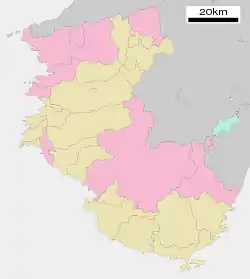
Geography
City Town Village
As of 31 March 2020, 13 percent of the total land area of the prefecture was designated as Natural Parks, namely the Setonaikai and Yoshino-Kumano National Parks; Kongō-Ikoma-Kisen and Kōya-Ryūjin Quasi-National Parks; and Enju Kaigan, Hatenashi Sanmyaku, Hikigawa, Jōgamori Hokodai, Kōyasanchō Ishimichi-Tamagawakyō, Kozagawa, Nishiarida, Oishi Kōgen, Ōtōsan, Ryūmonzan, Shiramisan-Wadagawakyō, and Shirasaki Kaigan Prefectural Natural Parks.[4]
Cities
Nine cities are in Wakayama Prefecture:
Towns and villages
These are the towns and villages in each district:
Mergers
Demographics
Since 1996, population of Wakayama Prefecture has kept declining, and since 2010, it has been the only prefecture in Kansai region with population below 1,000,000. In 2017, Wakayama is ranked 40th by population in Japan with a population of 944,320.
Politics
List of Governor of Wakayama (1947 to present)
|
|
Culture
Mount Kōya (高野山, Kōya-san) in the Ito District is the headquarters of the Shingon sect of Japanese Buddhism. It is home to one of the first Japanese style Buddhist temples in Japan and remains a pilgrimage site and an increasingly popular tourist destination as people flock to see its ancient temples set amidst the towering cedar trees at the top of the mountain. The Sacred sites and pilgrimage routes in the Kii Mountain Range extend for miles throughout the prefecture and together have been recognized as Japan's 11th UNESCO World Heritage site.[5]
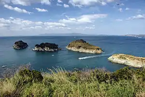
The Kumano Shrines are on the southern tip of the prefecture. Tomogashima (a cluster of four islands) is part of the prefecture.
Agriculture
Orange
Wakayama Prefecture ranks first in the production of oranges in Japan. Wakayama has its own brand of oranges, which is produced in Arida District and called 'Arida-Orange'. Arida District, where oranges have been produced for more than 400 years,[6] yields about half of the orange crops in Wakayama today.[7] Furthermore, the yield of Arida-Oranges accounts for about 10 percent of Japanese domestic production of oranges.[8]
Japanese apricot (Ume)
According to the survey by the Ministry of Agriculture, Forestry and Fisheries of Japan, Wakayama stands first in the production of Japanese apricots (梅, Ume) in Japan. As of 2016, Wakayama made up about 70 percent of Japanese domestic production of Japanese apricots.[9]
Sister relationships
Wakayama Prefecture has friendship and sister relationships with seven places outside Japan:[10] Richmond, Canada; Shandong, People's Republic of China; Pyrénées-Orientales, France; Florida, United States; Sinaloa, Mexico; Bakersfield, California and Galicia, Spain.
Tourism
Wakayama Prefecture has hot springs such as Shirahama, Kawayu, and Yunomine Onsen.
 Saikazaki, Wakanoura
 The Museum of Modern Art, Wakayama
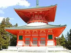 Konpon Daido
(Mount Koya)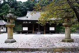 Chōhō-ji
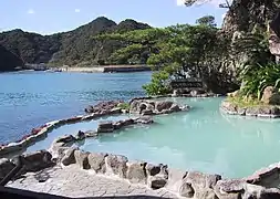
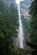
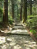 Daimonzaka
(Kumano Kodō)
Transportation
Rail
- JR West
- JR Central
- Nankai
- Kishu Railway
- Wakayama Electric Railway
Expressway
- Hanwa Expressway
- Keinawa Expressway
- Yuasa Gobo Road
- Nachi Katsuura Road
National Highway
Ferry
- Wakayama-Tokushima
Airport
Education
See also
- Statue of B. R. Ambedkar (Japan)
Notes
- Nussbaum, Louis-Frédéric. (2005). "Wakayama prefecture" in Japan Encyclopedia, p. 1026, p. 1026, at Google Books; "Kansai" in p. 477, p. 477, at Google Books.
- Nussbaum, "Wakayama" in p. 1025, p. 1025, at Google Books.
- Nussbaum, "Provinces and prefectures" in p. 780, p. 780, at Google Books.
- 自然公園都道府県別面積総括 [General overview of area figures for Natural Parks by prefecture] (PDF) (in Japanese). Ministry of the Environment. 31 March 2020. Retrieved 23 January 2020.
- UNESCO.org
- 今月の旬 Wakayama Prefecture website, accessed May 31, 2017
- 農林水産 特産品 Wakayama Prefecture website, accessed May 31, 2017
- 有田みかんについて JA Arida website, accessed May 31, 2017
- 作況調査(果樹): 農林水産省 The Ministry of Agriculture, Forestry and Fisheries website, accessed June 1, 2017
- 友好・姉妹提携 Archived 2011-06-11 at the Wayback Machine Wakayama Prefecture website, retrieved May 16, 2008
References
- Nussbaum, Louis-Frédéric and Käthe Roth. (2005). Japan encyclopedia. Cambridge: Harvard University Press. ISBN 978-0-674-01753-5; OCLC 58053128
External links
| Wikimedia Commons has media related to Wakayama prefecture. |
| Core city | Flag of Wakayama Prefecture | |
|---|---|---|
| Cities | ||
| Districts | ||
| Authority control |
|---|