K-120 (Kansas highway)
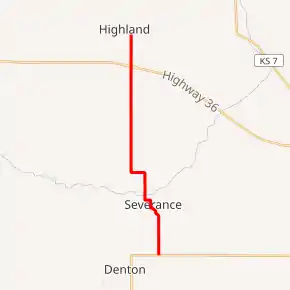
K-120 is a 9.126-mile-long (14.687 km) north–south state highway in the U.S. state of Kansas. K-120's southern terminus is at K-20 south of the City of Severance and the northern terminus is a continuation as Kansas Street at the Highland city limits.[3] Just south of its northern terminus it intersects U.S. Route 36 (US-36).
| ||||
|---|---|---|---|---|
K-120 highlighted in red | ||||
| Route information | ||||
| Maintained by KDOT | ||||
| Length | 9.126 mi[1] (14.687 km) | |||
| Existed | June 5, 1945[2]–present | |||
| Major junctions | ||||
| South end | ||||
| North end | Kansas Street at Highland city line | |||
| Location | ||||
| Counties | Doniphan | |||
| Highway system | ||||
| ||||

Before state highways were numbered in Kansas there were auto trails, K-120 follows the former Pikes Peak Ocean to Ocean Highway its entire length. K-120 was first designated on June 5, 1945, as a short spur from K-20 to Severence, then was extended northward to Highland by mid 1951.[2][4]
Route description
K-120 begins at an intersection with K-20 northeast of Denton and travels northward through small rolling hills covered in farmlands. After roughly 1.5 miles (2.4 km) it curves to the northwest and enters the city of Severance. It then curves west and begins to follow Church Street. The highway then turns onto Gove Street and continues north to an intersection with Power House Road. Here, it turns west and leaves the city then curves north again and crosses Wolf River, a tributary of the Missouri River.[5] It continues north, passes Oak Hill Cemetery at an intersection with 185th Road, then curves west. The highway continues for 0.5 miles (0.80 km) then curves back north again. From here it continues north for roughly 3.8 miles (6.1 km) and intersects US-36 via a diamond interchange. From US-36 it continues north for roughly one mile (1.6 km) through more farmlands and crosses Mission Creek, a tributary of the Missouri River. Roughly 0.2 miles (0.32 km) north of Mission Creek, it ends at the Highland city limits and continues as Kansas Street.[3][6][7]
The Kansas Department of Transportation (KDOT) tracks the traffic levels on its highways, and in 2017, they determined that on average the traffic varied from 450 vehicles per day near the southern terminus to 1380 vehicles per day between US-36 and the northern terminus.[8] The entire route is paved with partial design bituminous pavement.[9][10] K-120 is not included in the National Highway System.[11] The National Highway System is a system of highways important to the nation's defense, economy, and mobility. K-120 does connect to the National Highway System at its junction with US-36.[12]
History
Before state highways were numbered in Kansas there were auto trails, which were an informal network of marked routes that existed in the United States and Canada in the early part of the 20th century. K-120 follows the former Pikes Peak Ocean to Ocean Highway its entire length.[13]
K-120 was first established as a state highway on June 5, 1945, as a 1.8 miles (2.9 km) spur from K-20 north to Severence.[2] Then on May 9, 1951, K-120 was extended 6.702 miles (10.786 km) northward to end at US-36 in Highland.[4] Then in 1985, US-36 was realigned to a new alignment south of Highland and in an October 7, 1985 resolution, K-120 was truncated 0.193 miles (0.311 km) to end at the Highland city limits when the new alignment of US-36 was finished. Included in that resolution is if Highland annexs more land surrounding K-120, that section would be removed from the state highway system.[14]
Major intersections
The entire route is in Doniphan County.
| Location | mi[1] | km | Destinations | Notes | |
|---|---|---|---|---|---|
| Wolf River–Union township line | 0.000 | 0.000 | Southern terminus | ||
| Iowa Township | 8.933 | 14.376 | Diamond interchange | ||
| Highland | 9.126 | 14.687 | Kansas Street | Northern terminus; continuation as Kansas Street at Highland city limits | |
| 1.000 mi = 1.609 km; 1.000 km = 0.621 mi | |||||
References
- Staff (2016). "Pavement Management Information System". Kansas Department of Transportation. Retrieved April 16, 2017.
- State Highway Commission of Kansas (June 5, 1945). "Resolution establishing a road in Doniphan County as a part of the State Highway System". Topeka: State Highway Commission of Kansas. Retrieved August 26, 2019.
- Highway Planning Department (2010). Doniphan County (PDF) (Map). Scale not given. General Highway Map. Topeka: Kansas Department of Transportation. Retrieved August 26, 2019.
- State Highway Commission of Kansas (May 9, 1951). "Resolution for extension of State Highway in Doniphan County". Topeka: State Highway Commission of Kansas. Retrieved August 26, 2019.
- Bureau of Transportation Planning (July 2006). City of Severance (PDF) (Map). KDOT City Maps. Topeka: Kansas Department of Transportation. Retrieved August 18, 2020.
- Google (August 15, 2020). "Overview map of K-120" (Map). Google Maps. Google. Retrieved August 15, 2020.
- Bureau of Transportation Planning (January 2010). City of Highland (PDF) (Map). KDOT City Maps. Topeka: Kansas Department of Transportation. Retrieved August 18, 2020.
- Bureau of Transportation Planning (2018). Traffic Flow Map Kansas State Highway System (PDF) (Map). [c. 1:1,584,000]. Topeka: Kansas Department of Transportation. Retrieved July 29, 2019.
- Staff (July 19, 2012). "Pavement Management Information System Query". Kansas Department of Transportation. Retrieved January 22, 2013.
- Staff (May 9, 2012). "Pavement Management Information System Glossary". Kansas Department of Transportation.
- Federal Highway Administration (May 8, 2019). National Highway System: Kansas (PDF) (Map). [c. 1:3,900,000]. Federal Highway Administration. Retrieved August 25, 2019.
- Natzke, Stefan; Neathery, Mike; Adderly, Kevin (September 26, 2012). "What is the National Highway System?". National Highway System. Federal Highway Administration. Retrieved July 29, 2019.
- Rand McNally and Company (1924). "Kansas" (Map). AutoTrails Map, Southern Nebraska, Eastern Colorado, Kansas, Northeastern New Mexico, Northern Oklahoma. 1:1,600,000. Chicago: Rand McNally and Company. pp. 372–373. OCLC 2078375. Retrieved August 14, 2020 – via Rumsey Collection.
- State Highway Commission of Kansas (October 7, 1985). "Resolution for Relocation and Redesignation of four roads in Doniphan County". Topeka: State Highway Commission of Kansas. Retrieved August 26, 2019.