K-20 (Kansas highway)
K-20 is a 37.21-mile-long (59.88 km) west–east state highway in the northeastern part of the U.S. state of Kansas. It connects U.S. Route 75 (US-75) in the Kickapoo Nation Indian Reservation with K-7 southwest of Troy. Along the way K-20 intersects sever major highways including U.S. Route 159 in Horton and overlaps U.S. Route 73 from Horton to south of Everest. Northeast of Denton the highway intersects K-120, which travels north to Severance and Highland. K-20 travels through mostly rural farmlands and is a two-lane highway its entire length.
| ||||
|---|---|---|---|---|
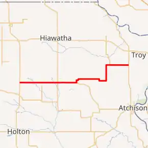
K-20 highlighted in red | ||||
| Route information | ||||
| Maintained by KDOT and the city of Horton | ||||
| Length | 37.210 mi[1] (59.884 km) | |||
| Existed | c. 1927[2][3]–present | |||
| Major junctions | ||||
| West end | ||||
| East end | ||||
| Location | ||||
| Counties | Brown, Doniphan | |||
| Highway system | ||||
| ||||

Before state highways were numbered in Kansas there were auto trails. K-20 overlaps the former Capitol Route near Horton. From Horton to south of Everest, the highway overlaps the former George Washington National Highway and King of Trails. The section from K-120 to Bendena overlaps the former Pikes Peak Ocean to Ocean Highway. K-20 was established between 1927 and 1930, and at that time ran from US-73E south of Everest east to K-16 south of Troy. By 1936, US-73E was renumbered to US-73 and K-16 was decommissioned and became an extension of K-7. On July 11, 1956, it was approved to extend K-20 from US-73 west to US-75 as soon as the county had improved the roadway. Then by August 1956, the county had finished required projects and it was officially extended.
Route description
K-20 begins at its western terminus at US-75 north of Holton on the border of the Kickapoo Indian Reservation. It travels east for about 1.9 miles (3.1 km) through mostly open pastures then intersects Dewberry Road. Past here, the landscape around the highway becomes more forested as it crosses an unnamed creek then intersects Falcon Road .8 miles (1.3 km) later. Here, the landscape transitions to mostly open pastures and continues east for .9 miles (1.4 km) then crosses Delaware River. It then passes through a group of houses and reaches Goldfinch Road, which travels north to Golden Eagle Casino. It continues east through rural grasslands and soon reaches an intersection with Hazelnut Drive, which marks the eastern border of the reservation. It continues for another one mile (1.6 km) past here then intersects Horned Owl Road, which travels north to Mercier. K-20 continues east through rural farmlands for 2.9 miles (4.7 km) then crosses Grasshopper Creek.[4][5]
The highway continues for another .4 miles (0.64 km) then enters Horton as 15th Street. It travels through the city for about .5 miles (0.80 km) then begins an overlap with US-73 and US-159. The three highways continue for 422 feet (129 m) then US-159 turns south, as K-20 and K-73 continue east. The two highways then pass Municipal Reservoir and cross Mission Creek, as the highway exits the city.[6] The two routes continue east through open farmlands then cross Otter Creek about 2.4 miles (3.9 km) later. Another 2.5 miles (4.0 km) past the creek, K-20 turns north toward Everest as US-73 continues east. K-20 continues north for .5 miles (0.80 km) then enters Everest as 5th Street. The highway soon reaches Main Street, where it turns east and crosses a Union Pacific Railway track. The highway then exits the city after .25 then curves north at Racoon Road.[7] The highway continues north for .25 miles (0.40 km) then curves back east. The highway continues through more open farmland for 2.5 miles (4.0 km) then crosses South Fork Wolf River. K-20 continues for about 1.5 miles (2.4 km) then enters into Doniphan County.[4][5]
About .5 miles (0.80 km) into the county, it intersects K-137 which travels south to Purcell. K-20 continues east for roughly 1.5 miles (2.4 km) then curves south for .5 miles (0.80 km), then back east. It passes through rural farmlands for two miles (3.2 km) then curves north at Coronado Road and 115th Street. The highway continues north through flat rural farmlands with scattered areas of trees for three miles (4.8 km) then crosses North Branch Independence River. K-20 continues past here for .7 miles (1.1 km) then passes along the east border of Denton. The highway then curves east about .5 miles (0.80 km) later at a junction with 160th Road. It continues east for one mile (1.6 km) then intersects K-120, which travels north to Severance. K-20 then passes by school and continues for three miles (4.8 km) and reaches Bendena. The highway continues for another roughly two miles (3.2 km) through rural farmlands and reaches its eastern terminus at K-7 southwest of Troy.[8][5]
The Kansas Department of Transportation (KDOT) tracks the traffic levels on its highways, and in 2018, they determined that on average the traffic varied from 190 vehicles per day near slightly east of Purcell to 2910 vehicles per day slightly east of Horton along the overlap with US-73.[9] K-20 is not included in the National Highway System,[10] a system of highways important to the nation's defense, economy, and mobility.[11] K-20 does connect to the National Highway System at its western terminus.[10]
History
Early roads
Before state highways were numbered in Kansas there were auto trails, which were an informal network of marked routes that existed in the United States and Canada in the early part of the 20th century. K-20 overlaps the former Capitol Route from Horned Owl Road to Horton. From Horton to south of Everest, the highway overlaps the former George Washington National Highway and King of Trails. The section from K-120 to Bendena overlaps the former Pikes Peak Ocean to Ocean Highway.[12]
Establishment and realignments
K-20 was established between 1927 and 1930, and at that time ran from US-73E south of Everest east to K-16 south of Troy.[2][3] Between 1933 and 1934, US-73E was renumbered to US-73 and K-16 was decommissioned and became an extension of K-7.[13][14] This section was paved in 1948.[15] In a July 11, 1956 meeting, it was approved to extend K-20 from US-73 west 10.356 miles (16.666 km) to US-75 as soon as the county had cleared brush and the ditches as well as fixing the slope of the roadway. Then by August 1956, the county had finished required projects and in an August 9, 1956 meeting, it was officially extended.[16]
On July 12, 1950, the section of K-20 from US-73 to the city of Everest was established as K-114. The commission authorized relocations of US-73 and K-20 in and around Everest through an August 12, 1964, resolution. The eastern end of K-20's concurrency with US-73 had been southeast of Everest. K-20 was relocated to pass through Everest and assume the course of K-114. This made its new US-73 junction at what was K-114's southern terminus.[17] K-114 was replaced by K-20 when the relocations were completed in 1966.[18][19]
Major intersections
| County | Location | mi[1] | km | Destinations | Notes |
|---|---|---|---|---|---|
| Brown | Powhattan Township | 0.000 | 0.000 | Western terminus; road continues as 110th Street | |
| Horton | 10.856 | 17.471 | Western end of US-73/US-159 concurrency | ||
| 10.937 | 17.601 | Eastern end of US-159 concurrency | |||
| Everest | 16.329 | 26.279 | Eastern end of US-73 concurrency | ||
| Doniphan | Union Township | 22.310 | 35.904 | Northern terminus of K-137 | |
| Union–Wolf River township line | 31.800 | 51.177 | Southern terminus of K-120 | ||
| Independence–Center township line | 37.210 | 59.884 | Eastern terminus; road continues as 160th Road | ||
1.000 mi = 1.609 km; 1.000 km = 0.621 mi
| |||||
See also
 Kansas portal
 U.S. Roads portal
References
- Staff (2016). "Pavement Management Information System". Kansas Department of Transportation. Retrieved April 21, 2017.
- Rand McNally and Company (1927). "Kansas" (Map). Rand McNally Auto Road Atlas of the United States and Ontario, Quebec, and the Maritime Provinces of Canada, with a Brief Description of the National Parks and Monuments. 1:1,600,000. Chicago: Rand McNally and Company. pp. 54–55. OCLC 2078375. Retrieved October 10, 2020 – via Rumsey Collection.
- Rand McNally and Company (1930). "Kansas" (Map). Rand McNally Junior Auto Road Map of Kansas. Chicago: Rand McNally and Company. Retrieved October 10, 2020.
- Bureau of Transportation Planning (February 2008). Republic County (PDF) (Map). [c. 1: 211,200]. General Highway Map. Topeka: Kansas Department of Transportation. Retrieved October 17, 2020.
- Google (October 17, 2020). "Overview map of K-20" (Map). Google Maps. Google. Retrieved October 17, 2020.
- Bureau of Transportation Planning (January 2007). City of Horton (PDF) (Map). Scale not given. KDOT City Maps. Topeka: Kansas Department of Transportation. Retrieved October 17, 2020.
- Bureau of Transportation Planning (May 2004). City of Everest (PDF) (Map). Scale not given. KDOT City Maps. Topeka: Kansas Department of Transportation. Retrieved October 17, 2020.
- Bureau of Transportation Planning (September 2010). Doniphan County (PDF) (Map). [c. 1: 211,200]. General Highway Map. Topeka: Kansas Department of Transportation. Retrieved October 17, 2020.
- Bureau of Transportation Planning (2018). Traffic Flow Map Kansas State Highway System (PDF) (Map). [c. 1:1,584,000]. Topeka: Kansas Department of Transportation. Retrieved October 11, 2020.
- Federal Highway Administration (May 8, 2019). National Highway System: Kansas (PDF) (Map). Scale not given. Washington, DC: Federal Highway Administration. Retrieved October 11, 2020.
- Natzke, Stefan; Neathery, Mike; Adderly, Kevin (September 26, 2012). "What is the National Highway System?". National Highway System. Washington, DC: Federal Highway Administration. Retrieved October 11, 2020.
- Rand McNally and Company (1924). "Kansas" (Map). AutoTrails Map, Southern Nebraska, Eastern Colorado, Kansas, Northeastern New Mexico, Northern Oklahoma. 1:1,600,000. Chicago: Rand McNally and Company. OCLC 2078375. Retrieved October 17, 2020 – via Rumsey Collection.
- State Highway Commission of Kansas (1933). Kansas State Highway System (PDF) (Map). Scale not given. Topeka: State Highway Commission of Kansas. Retrieved October 14, 2020.
- Continental Oil Company (1934). Kansas (Map). Denver: Continental Oil Company.
- "New Surface on Kansas Route 20". St. Joseph News-Press. St. Joseph, Missouri. October 25, 1948. p. 4. Retrieved October 17, 2020 – via Newspapers.com.
- Kansas State Highway Commission (August 9, 1956). "Certification by State Highway Engineer for addition of road in Brown County to the State Highway System". Topeka: Kansas State Highway Commission. Retrieved October 11, 2020.
- Kansas State Highway Commission (August 12, 1964). "Resolution for Relocation and Redesignation of Road in Brown County and Atchison County". Topeka: Kansas Department of Transportation. Retrieved April 29, 2017.
- Official Kansas Highway Map (PDF) (Map) (1966 ed.). Topeka: Kansas State Highway Commission. §§ B11, C9. Retrieved October 11, 2020.
- Official Kansas Highway Map (PDF) (Map) (1967 ed.). Topeka: Kansas State Highway Commission. §§ B11, C9. Retrieved October 11, 2020.