K-207 (Kansas highway)
K-207 was a 0.600-mile-long (0.966 km) state highway in the U.S. state of Kansas. K-207's southern terminus was at Interstate 70 (I-70), K-18 and the eastern terminus of K-207 Alt. in Junction City, and the northern terminus was at US-40 Bus. in Junction City. K-207 is now known as East Street.
| ||||
|---|---|---|---|---|
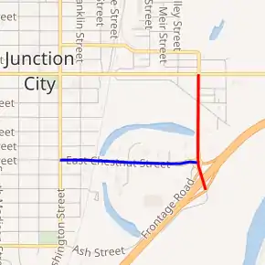
Former K-207 in red, former K-207 Alternate in blue | ||||
| Route information | ||||
| Maintained by KDOT | ||||
| Length | 0.600 mi[1] (0.966 km) | |||
| Existed | September 24, 1958[2]–July 20, 1992[3] | |||
| Major junctions | ||||
| South end | ||||
| North end | ||||
| Location | ||||
| Counties | Geary | |||
| Highway system | ||||
| ||||

K-207 was established in a September 24, 1958 resolution. It remained at the same alignment, until removed K-207 from the state highway system in a July 20, 1992 resolution.
Route description
K-207 began at a diamond interchange with I-70 and K-18, at current exit 298. It then headed north and immediately intersected the eastern terminus of K-207 Alternate. From here it continued north along East Street for a short distance before terminating at US-40 Business (6th Street).
The Kansas Department of Transportation (KDOT) tracks the traffic levels on its highways, and in 1991, they determined that on average the traffic was 625 vehicles between K-107 Alternate and its northern terminus.[4]
History
K-207 was established in a September 24, 1958 resolution.[2] The Kansas Department of Transportation removed K-207 from the state highway system in a July 20, 1992 resolution.[3]
Major intersections
The entire route was in Junction City, Geary County.
| mi[1] | km | Destinations | Notes | ||
|---|---|---|---|---|---|
| 0.000– 0.200 | 0.000– 0.322 | Southern terminus; eastern terminus of K-207 Alt.; I-70 exit 298 | |||
| 0.600 | 0.966 | Northern terminus | |||
| 1.000 mi = 1.609 km; 1.000 km = 0.621 mi | |||||
Alternate route
| |
|---|---|
| Location | Junction City |
| Length | 0.520 mi (0.837 km) |
| Existed | 1959–July 20, 1992[3] |
K-207 Alt. was a 0.700-mile-long (1.127 km) state highway in the U.S. state of Kansas. K-207 Alt.'s western terminus was at US-77 Alt. and US-40 Bus. in Junction City and the eastern terminus was at Interstate 70 (I-70), K-18 and the southern terminus of K-207 in Junction City. K-207 Alt. was established in a September 9, 1959 resolution.[5] The Kansas Department of Transportation removed K-207 Alt. from the state highway system in a July 20, 1992 resolution.[3] In 1991, the average daily traffic was 1495 vehicles on K-107 Alternate.[4] It is now known as Chestnut Street.
The entire route was in Junction City, Geary County.
| mi[1] | km | Destinations | Notes | ||
|---|---|---|---|---|---|
| 0.000 | 0.000 | Western terminus | |||
| 0.520 | 0.837 | Eastern terminus; southern terminus of K-207; I-70 exit 298 | |||
| 1.000 mi = 1.609 km; 1.000 km = 0.621 mi | |||||
References
- Staff (2016). "Pavement Management Information System". Kansas Department of Transportation. Retrieved April 16, 2017.
- Kansas State Highway Commission (September 24, 1958). "Resolution for relocation and redesignation of road in Geary County". Topeka: Kansas State Highway Commission. Retrieved April 22, 2020.
- Kansas State Highway Commission (July 20, 1992). "Resolution to withdraw two highways in Geary County". Topeka: Kansas State Highway Commission. Retrieved April 22, 2020.
- Bureau of Transportation Planning (1991). Traffic Flow Map Kansas State Highway System (PDF) (Map). [c. 1:1,584,000]. Topeka: Kansas Department of Transportation. Retrieved April 22, 2020.
- Kansas State Highway Commission (September 9, 1959). "Resolution for addition to State Highway System Geary County". Topeka: Kansas State Highway Commission. Retrieved April 22, 2020.