K-53 (Kansas highway)
K-53 is a 6.177-mile-long (9.941 km) state highway in the U.S. State of Kansas. Located entirely within Sumner County, K-53's western terminus is at U.S. Route 81 (US-81) south of Wichita and the eastern terminus is at an interchange with K-15 by Mulvane. Along the way K-53 intersects Interstate 35 (I-35), also known as the Kansas Turnpike, at exit 33. The highway travels mostly through farmlands with the exception of inside Mulvane and is a two-lane road its entire length.
| ||||
|---|---|---|---|---|
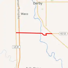
K-53 highlighted in red | ||||
| Route information | ||||
| Maintained by KDOT and the city of Mulvane | ||||
| Length | 6.177 mi[1] (9.941 km) | |||
| Existed | 1927[2]–present | |||
| Major junctions | ||||
| West end | ||||
| East end | ||||
| Location | ||||
| Counties | Sumner | |||
| Highway system | ||||
| ||||

Before state highways were numbered in Kansas there were auto trails. The western terminus follows the former Meridian Highway and Southwest Trail. K-53 was designated a state highway by the Kansas State Highway Commission by 1927. Its alignment has remained the same since, except for minor realignments near the crossing of the Arkansas River. Between 1986 and 1987, an interchange was built to provide access to the Kansas Turnpike and I-35.
Route description
K-53 begins at US-81 on the Sedgwick–Sumner county line. It travels east through flat rural farmlands and after about .53 miles (0.85 km) passes under I-35 and Kansas Turnpike. The highway continues about .1 miles (0.16 km) then intersects an unnamed road that connects to exit 33 of the Kansas Turnpike and I-35. K-53 continues for .42 miles (0.68 km) then crosses Cowskin Creek and becomes surrounded by trees. The highway then passes to the north of a group of houses then transitions back to flat open farmlands. It continues to straddle the county line until it crosses the Arkansas River about 1.9 miles (3.1 km) later. K-53 then turns southeast into Sumner County, remaining there the remainder of its length. The highway then curves east and enters the city of Mulvane becoming West Bridge Street. It continues another .3 miles (0.48 km) to an at-grade crossing with a BNSF Railway track then curves north and becomes 1st Street. K-53 continues for about .2 miles (0.32 km) then turns east onto Main Street. The highway continues for .73 miles (1.17 km) where it passes under a BNSF Railway track and exits Mulvane. The road continues a short distance and reaches a partial cloverleaf interchange with K-15.[3][4][5]
The Kansas Department of Transportation (KDOT) tracks the traffic levels on its highways, and in 2017, they determined that on average the traffic varied from 1900 vehicles per day near the eastern terminus to 4470 vehicles per day in Mulvane.[6] K-53 is not included in the National Highway System.[7] The National Highway System is a system of highways important to the nation's defense, economy, and mobility. K-53 is connected to the National Highway System at its intersection with I-35 and at its eastern terminus at K-15.[8] The entire route is paved with partial design bituminous pavement.[1][9] The entire 1.278 miles (2.057 km) section of K-53 within Mulvane is maintained by the city.[10]
History
Early roads
Before state highways were numbered in Kansas there were auto trails, which were an informal network of marked routes that existed in the United States and Canada in the early part of the 20th century. K-53's western terminus was part of the South West Trail, which ran from El Paso, Texas to Chicago, Illinois. It was also part of the Meridian Highway, which ran from Laredo, Texas north to Pembina, North Dakota.[11] The Meridian Highway was formed in 1911 in Kansas.[12]:7
Establishment and realignments
K-53 was designated as a state highway by the Kansas State Highway Commission by 1927, to a highway extending from US-81 east to K-15 in Mulvane.[2] In an August 24, 1949 resolution, it was approved to slightly realign K-53 near the crossing of the Arkansas River.[13] Then in an August 13, 1952 resolution, K-53 was realigned again by the Arkansas River due to a new bridge being built across the river.[14] In an October 28, 1953 resolution, it was approved to build a new alignment of K-15, from where it turned west towards Mulvane (East 119th Street), north to Derby.[15] In early February 1954, the State Highway Commission approved a bid of $78,210 (equivalent to $745 thousand in 2021) for grading to T.F. Marbut of Emporia and a bid of $69,965 (equivalent to $666 thousand in 2021) for building of bridges to E.W. Geiger of Topeka for a roughly four-mile (6.4 km) section of K-15 from Derby southeast towards Mulvane.[16] Then on November 29, 1954, the State Highway Commission approved a bid of $34,040 (equivalent to $324 thousand in 2021) for grading to Harry Henery of Ottawa and a bid of $67,875 (equivalent to $646 thousand in 2021) for building of three bridges to O.G. Brommer of Belleville for the remaining 1.3-mile (2.1 km) section of K-15 toward Mulvane.[17] By 1956, the new alignment was complete, and at that time K-53 was extended east along East Main Street to the new alignment.[18] When the Kansas Turnpike was completed in 1956, there was no connection with K-53.[19] Between 1986 and 1987, exit 33 was completed along the turnpike to provide a connection with K-53.[20][21]
Major junctions
| County | Location | mi[1] | km | Destinations | Notes |
|---|---|---|---|---|---|
| Sedgwick–Sumner county line | Salem–Belle Plain township line | 0.000 | 0.000 | Western terminus; road continues west as 119th Street South | |
| 0.658[5] | 1.059 | Access via connector road; exit 33 on I-35/Kansas Tpke. | |||
| Sumner | Mulvane | 6.177 | 9.941 | Eastern terminus; partial cloverleaf interchange; road continues east as 119th Street South | |
1.000 mi = 1.609 km; 1.000 km = 0.621 mi
| |||||
References
- Staff (2016). "Pavement Management Information System". Kansas Department of Transportation. Retrieved April 22, 2017.
- Rand McNally and Company (1927). "Kansas" (Map). Rand McNally Auto Road Atlas of the United States and Ontario, Quebec, and the Maritime Provinces of Canada, with a Brief Description of the National Parks and Monuments. 1:1,600,000. Chicago: Rand McNally and Company. pp. 54–55. OCLC 2078375 – via Rumsey Collection.
- Bureau of Transportation Planning (September 1, 2009). City of Mulvane (PDF) (Map). Scale not given. KDOT City Maps. Topeka: Kansas Department of Transportation. Retrieved January 3, 2021.
- Bureau of Transportation Planning (May 2010). Sumner County (PDF) (Map). [c. 1: 211,200]. General Highway Map. Topeka: Kansas Department of Transportation. Retrieved January 3, 2021.
- "Overview of K-53". Google Maps. Google, Inc. Retrieved September 3, 2016.
- Bureau of Transportation Planning (2018). Traffic Flow Map Kansas State Highway System (PDF) (Map). [c. 1:1,584,000]. Topeka: Kansas Department of Transportation. Retrieved September 2, 2019.
- National Highway System: Kansas (PDF) (Map). Federal Highway Administration. Retrieved September 2, 2019.
- Natzke, Stefan; Neathery, Mike; Adderly, Kevin (September 26, 2012). "What is the National Highway System?". National Highway System. Federal Highway Administration. Retrieved September 2, 2019.
- Staff (2012-05-09). "Pavement Management Information System Glossary". Kansas Department of Transportation.
- Kansas Department of Transportation (April 8, 1997). "Resolution Designating City Connecting Links in State Highway System". Topeka: Kansas Department of Transportation. Retrieved September 8, 2020.
- Rand McNally and Company (1924). "Kansas" (Map). AutoTrails Map, Southern Nebraska, Eastern Colorado, Kansas, Northeastern New Mexico, Northern Oklahoma. 1:1,600,000. Chicago: Rand McNally and Company. OCLC 2078375. Retrieved June 22, 2020 – via Rumsey Collection.
- Christina Slattery; Chad D. Moffett; L. Robert Puschendorf (July 2001). "National Register of Historic Places Registration Form: Meridian Highway" (PDF). National Park Service. Retrieved January 3, 2021. 12 Photos
- State Highway Commission of Kansas (August 24, 1949). "Resolution for Relocation and Redesignation of Road in Sumner County". Topeka: State Highway Commission of Kansas. Retrieved September 2, 2019.
- State Highway Commission of Kansas (August 13, 1952). "Resolution for Relocation and Redesignation of Road in Sumner County". Topeka: State Highway Commission of Kansas. Retrieved September 2, 2019.
- State Highway Commission of Kansas (October 28, 1953). "Resolution for Relocation and Redesignation of Road in Sedgwick County". Topeka: State Highway Commission of Kansas. Retrieved January 3, 2021.
- "Great Bend Firm Low Bidder For Pratt Paving Job". Great Bend Tribune. February 5, 1954. p. 4. Retrieved January 3, 2021 – via Newspapers.com.
- "Work Ordered To Begin On Large Road Work Jobs". Great Bend Tribune. November 30, 1954. p. 4. Retrieved January 3, 2021 – via Newspapers.com.
- State Highway Commission of Kansas (1956). Kansas State Highway System (PDF) (Map). Scale not given. Topeka: State Highway Commission of Kansas. Retrieved January 3, 2021.
- State Highway Commission of Kansas (1957–1958). Kansas State Highway System (PDF) (Map). Scale not given. Topeka: State Highway Commission of Kansas. Retrieved January 3, 2021.CS1 maint: date format (link)
- Kansas Department of Transportation (1986). Kansas State Highway System (PDF) (Map). Scale not given. Topeka: Kansas Department of Transportation. Retrieved January 3, 2021.
- Kansas Department of Transportation (1987). Kansas State Highway System (PDF) (Map). Scale not given. Topeka: Kansas Department of Transportation. Retrieved January 3, 2021.