Kagoshima Bay
Kagoshima Bay (鹿児島湾, Kagoshima-wan) is a deep inlet of the East China Sea on the coast of Japan.[1]
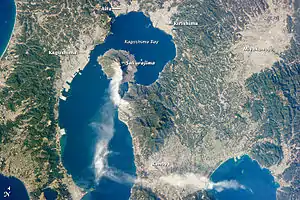
Kagoshima Bay is on the south coast of the island of Kyūshū. The port city of Kagoshima and its well-protected harbor lie on the bay's western coast, just opposite the island of Sakurajima.[1]
The bay itself is partially volcanic in origin, with two massive submarine calderas shaping part of the bay's shoreline: The younger Aira Caldera in the northernmost part of the bay, and the older Ata Caldera at the mouth of the bay where it meets the East China Sea. Both calderas formed during the Pleistocene from highly explosive Ultra-Plinian volcanic eruptions, Aira approximately 22,000 years ago and Ata approximately 105,000 years ago. Though such enormous eruptions are extremely infrequent, both volcanoes have remained active with much smaller eruptions in historic times, with Sakurajima in the bay and the Kirishima Mountains north of the bay forming active vents of the Aira volcano, and the smaller 4000-year-old Ikeda Caldera with Mount Kaimon at the southern end of the Satsuma Peninsula forming dormant vents of the Ata volcano.[2][3]
The Bombardment of Kagoshima by British warships in the bay took place in 1863. The 1914 eruption of the Sakurajima volcano severely damaged Kagoshima.[1]
Notes
- Merriam Webster's Geographical Dictionary, Third Edition, p. 562.
- Global Volcanism Program - Aira
- Global Volcanism Program - Ata
References
- Merriam Webster's Geographical Dictionary, Third Edition. Springfield, Massachusetts: Merriam-Webster, Incorporated, 1997. ISBN 0-87779-546-0.
| Authority control |
|---|