Kaingaroa Forest
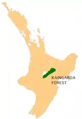
Kaingaroa Forest covers 2900 km² of the Bay of Plenty region of New Zealand, and is the largest forest plantation in New Zealand, and the second largest in the Southern Hemisphere (after the 6000km² Sabie/Graskop plantation in South Africa).[1] The forest stretches from Lake Taupo in the south to Kawerau to the north. The headquarters of the forest are at the small settlement of Kaingaroa, Bay of Plenty, 50 kilometres southeast of Rotorua.[2] Prior to planting the area was a tussock and scrub plateau (ranging between 500 ft (150 m) and 2,481 ft (756 m) high), formed on volcanic ash.[3]
The New Zealand Ministry for Culture and Heritage gives a translation of "long area of land" for Kāingaroa.[4]
The forest was first planted in the late 1920s[5][6] and owned as a state asset by the New Zealand government. Experimental planting of douglas fir and radiata pine began on a 5 acres (2.0 ha) block at Kaingaroa in 1901 and continued from 1906 using Waiotapu prison labour. 128 2.1 By 1932 the pines averaged 128 ft (39 m) high and 2.1 ft (0.64 m) in diameter. Later planting was as an unemployment relief scheme.[3] While under government control it was known as the Kaingaroa State Forest.
In the 1980s the government sought to sell the forests to private interests. Several Māori iwi went to Court to prevent the sale, arguing that they were the traditional owners of the land, that the land had been wrongfully taken from them, and that the government should retain the land until a settlement of the claims had been reached.[7][8] It has taken 20 years to reach settlement of those claims and to see the forest lands returned to their traditional owners. On 1 July 2009, it passed to a group of tribes that were the traditional land owners in partial settlement of their claims that the Crown breached the Treaty of Waitangi. The forests themselves (the trees) continue to be owned by a private company (Kaingaroa Timberlands Ltd), which holds a forestry licence over the land.
New Zealand State Highway 38, from Wai-O-Tapu to Murupara crosses the forest.
References
- http://www.sabie.co.za/about/forestry/index.html
- "Hell in the heartland". The Sunday Star-Times. 2 August 2008. Retrieved 15 June 2012.
- "Miles Of Trees – The Kaingaroa Plains". New Zealand Herald. 22 March 1933. p. 6. Retrieved 26 June 2016.
- "1000 Māori place names". New Zealand Ministry for Culture and Heritage. 6 August 2019.
- "New Zealand forestry and the forest code of practice"
- "The first planting boom, 1925–1935"
- "Treelord deal takes a step closer". National Business Review. NZPA. 11 June 2008. Archived from the original on 10 June 2011. Retrieved 8 October 2011.
- "Largest ever Treaty deal 'Treelords' passes into law". The New Zealand Herald. NZPA. 25 September 2008. Retrieved 8 October 2011.
External links
- Photos