Murupara
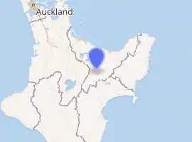
Murupara is a town located in the Whakatāne District and Bay of Plenty Region of New Zealand's North Island. The town is situated in an isolated part of the region between the Kaingaroa Forest and Te Urewera protected area, on the banks of the Rangitaiki River, 65 kilometres southeast of Rotorua.
Murupara | |
|---|---|
 View from Murupara looking east over the Whirinaki River towards Galatea | |
| |
| Coordinates: 38°28′S 176°42′E | |
| Country | New Zealand |
| Region | Bay of Plenty |
| Territorial authority | Whakatāne District |
| Ward | Galatea-Murupara |
| Population (June 2020)[1] | |
| • Total | 1,970 |
| Postcode(s) | 3025 |
It is located on SH38 and is the terminus of the Murupara Railway Branch. The town's principal industries are all related to forestry.[2]
Murupara is in the rohe (tribal area) of the Ngāti Manawa iwi.[3]
The Māori language name Murupara means "to wipe off mud".[4]
History and culture
History
Murupara was previously a staging post on the road between Rotorua and Napier. In the early 1900s, the planting of exotic trees began on the surrounding scrubland. This area is now known as the Kaingaroa Forest, with 1,400 square kilometres of planted pines. As the main service centre for the many forestry workers and their families, Murupara grew to a population of over 3,000. Recent changes to the forestry contracting system have brought about a decrease in the number of permanent residents.
The settlements of Galatea, Horomanga, Kopuriki, Aniwhenua, Waiohau and Murupara lie between the boundary of the Kaingaroa Forest, the popular Te Urewera and Whirinaki Te Pua-a-Tāne Conservation Park. Earlier history is also evident around Murupara. In a rock shelter approximately eight kilometres west of the town centre are a number of ancient cave drawings.
Murupara was regarded as being a "gang town" but local iwi have placed a rāhui (ban) on gang patches from being worn at the local marae and school.[5][6]
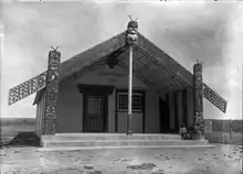
Marae
Murupara has several marae, which are meeting places for Ngāti Manawa hapū:[3][7]
- Moewhare or Karangaranga Marae and Moewhare meeting house are affiliated with Moewhare.
- Rangitahi Marae and Apahapaitaketake meeting house are affiliated with Ngāti Hui.
- Tīpapa Kakanui Marae and Tangiharuru meeting house are affiliated with Ngāi Tokowaru.
In October 2020, the Government committed $1,327,283 from the Provincial Growth Fund to upgrade Mowhare Marae, Rangitahi Marae, Tīpapa Marae and Painoaiho Marae, creating 12 jobs. It also committed $3,996,258 to upgrade Tīpapa Kakanui Marae and 7 other marae.[8]
Demographics
| Year | Pop. | ±% p.a. |
|---|---|---|
| 2006 | 1,872 | — |
| 2013 | 1,671 | −1.61% |
| 2018 | 1,815 | +1.67% |
| Source: [9] | ||
Murupara had a population of 1,815 at the 2018 New Zealand census, an increase of 144 people (8.6%) since the 2013 census, and a decrease of 57 people (-3.0%) since the 2006 census. There were 549 households. There were 891 males and 924 females, giving a sex ratio of 0.96 males per female. The median age was 29.1 years (compared with 37.4 years nationally), with 525 people (28.9%) aged under 15 years, 393 (21.7%) aged 15 to 29, 714 (39.3%) aged 30 to 64, and 186 (10.2%) aged 65 or older.
Ethnicities were 20.2% European/Pākehā, 91.2% Māori, 3.3% Pacific peoples, 0.8% Asian, and 0.8% other ethnicities (totals add to more than 100% since people could identify with multiple ethnicities).
The proportion of people born overseas was 1.8%, compared with 27.1% nationally.
Although some people objected to giving their religion, 40.3% had no religion, 39.3% were Christian, 0.2% were Buddhist and 13.4% had other religions.
Of those at least 15 years old, 60 (4.7%) people had a bachelor or higher degree, and 423 (32.8%) people had no formal qualifications. The median income was $18,800, compared with $31,800 nationally. The employment status of those at least 15 was that 420 (32.6%) people were employed full-time, 180 (14.0%) were part-time, and 183 (14.2%) were unemployed.[9]
Education
Murupara Area School is a co-educational state area school for Year 1 to 13 students,[10][11] with a roll of 280 as of March 2020.[12] It opened in 2013, when the local primary and secondary schools merged.[13]
Te Kura Kaupapa Motuhake o Tāwhiuau is a co-educational state Māori language immersion school,[14] with a roll of 75. [15] The school opened in 2000, and was the first Designated Character School (Kura ā-Iwi) in the country.[16][17]
Notable people
- Jacinda Ardern (born 1980), Prime Minister of New Zealand and leader of the Labour Party
- Pem Bird, president of the Maori Party 2010–2013
- Bradley Iles, professional golfer
- Willie Ripia, Rugby union player
References
- "Population estimate tables - NZ.Stat". Statistics New Zealand. Retrieved 22 October 2020.
- "Murupara Travel Guide". Jasons Travel Media.
- "Te Kāhui Māngai directory". tkm.govt.nz. Te Puni Kōkiri.
- Discover New Zealand:A Wises Guide (9th ed.). 1994. p. 116.
- Katee Shanks and Greg Taipari (20 November 2009). "Big push for ban on gang patches". The Daily Post.
- Davison, Isaac (15 November 2012). "School backs ban on gang regalia". APN New Zealand. New Zealand Herald.
- "Māori Maps". maorimaps.com. Te Potiki National Trust.
- "Marae Announcements" (Excel). growregions.govt.nz. Provincial Growth Fund. 9 October 2020.
- "Statistical area 1 dataset for 2018 Census". Statistics New Zealand. March 2020. Murupara (203600). 2018 Census place summary: Murupara
- "Murupara Area School Official School Website". mas.school.nz.
- "Murupara Area School Ministry of Education School Profile". educationcounts.govt.nz. Ministry of Education.
- "New Zealand Schools Directory". New Zealand Ministry of Education. Retrieved 26 April 2020.
- "Murupara Area School Education Review Office Report". ero.govt.nz. Education Review Office.
- "Te Kura Kaupapa Motuhake o Tawhiuau Ministry of Education School Profile". educationcounts.govt.nz. Ministry of Education.
- "Te Kura Kaupapa Motuhake o Tawhiuau Education Review Office Report". ero.govt.nz. Education Review Office.
- "Mōku te Awatea". Te Kura Kaupapa Motuhake o Tāwhiuau. 14 April 2020.
- "Members of the Independent Panel - Pembroke (Pem) Bird". Te Puni Kōkiri. 8 March 2018.