Kangasniemi
Kangasniemi is a municipality in the Southern Savonia region, Finland. The municipality has a population of 5,335 (31 July 2020)[2] and covers an area of 1,326.75 square kilometres (512.26 sq mi) of which 256.86 km2 (99.17 sq mi) is water.[1] The population density is 4.99 inhabitants per square kilometre (12.9/sq mi).
Kangasniemi | |
|---|---|
Municipality | |
| Kangasniemen kunta Kangasniemi kommun | |
 Coat of arms | |
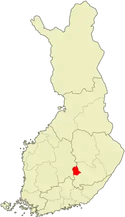 Location of Kangasniemi in Finland | |
| Coordinates: 61°59.4′N 026°38.5′E | |
| Country | |
| Region | Southern Savonia |
| Sub-region | Mikkeli sub-region |
| Charter | 1867 |
| Government | |
| • Municipal manager | Pekka Toivonen |
| Area (2018-01-01)[1] | |
| • Total | 1,326.75 km2 (512.26 sq mi) |
| • Land | 1,069.87 km2 (413.08 sq mi) |
| • Water | 256.86 km2 (99.17 sq mi) |
| Area rank | 73rd largest in Finland |
| Population (2020-07-31)[2] | |
| • Total | 5,335 |
| • Rank | 163rd largest in Finland |
| • Density | 4.99/km2 (12.9/sq mi) |
| Population by native language | |
| • Finnish | 98.9% (official) |
| • Swedish | 0.2% |
| • Others | 0.9% |
| Population by age | |
| • 0 to 14 | 13.3% |
| • 15 to 64 | 59.6% |
| • 65 or older | 27.1% |
| Time zone | UTC+02:00 (EET) |
| • Summer (DST) | UTC+03:00 (EEST) |
| Municipal tax rate[5] | 19.5% |
| Website | www.kangasniemi.fi |
Kangasniemi is located on the Finnish national road 13, 50 km (31 mi) northwest of Mikkeli and 63 km (39 mi) southeast of Jyväskylä. Distance to the national capital, Helsinki is 250 km (160 mi). Its neighbour municipalities are Hankasalmi, Hirvensalmi, Joutsa, Mikkeli, Pieksämäki and Toivakka.
There are almost 3600 (May 2014) summer houses, and summer guests redouble the number of inhabitants during the summer months.
The municipality is unilingually Finnish.
History
The municipality was founded in 1867.
Nature
There are more than 1,550 kilometres (960 mi) of shoreline. The largest lakes are Puulavesi and Kyyvesi. Some other lakes are Mallos and Synsiä. In 1997, Kangasniemi was voted the most beautiful municipality in Finland by television show.
Economy
Kangasniemi has large forest resources, approximately 12,000,000 cubic metres (420,000,000 cu ft), and the yearly growth is approximately 500,000 m3 (18,000,000 cu ft). There is also Puula golf field.
Gallery
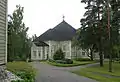 Church
 Läsäkoski canal
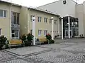 Borough hall
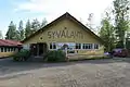 Syvälahden lava
See also
Famous natives
- Hilding Ekelund, architect
- Otto Manninen, writer, poet and translator
- Tepa Reinikainen, shot putter
- Hiski Salomaa, singer and songwriter
- Virpi Sarasvuo, née Kuitunen, cross-country skier
- Sami Sarjula, actor
- Martti Tolamo, athlete
References
- "Area of Finnish Municipalities 1.1.2018" (PDF). National Land Survey of Finland. Retrieved 30 January 2018.
- "Suomen virallinen tilasto (SVT): Väestön ennakkotilasto [verkkojulkaisu]. Heinäkuu 2020" (in Finnish). Statistics Finland. Retrieved 13 September 2020.
- "Population according to language and the number of foreigners and land area km2 by area as of 31 December 2008". Statistics Finland's PX-Web databases. Statistics Finland. Retrieved 29 March 2009.
- "Population according to age and gender by area as of 31 December 2008". Statistics Finland's PX-Web databases. Statistics Finland. Retrieved 28 April 2009.
- "List of municipal and parish tax rates in 2011". Tax Administration of Finland. 29 November 2010. Retrieved 13 March 2011.
External links
![]() Media related to Kangasniemi at Wikimedia Commons
Media related to Kangasniemi at Wikimedia Commons
- Municipality of Kangasniemi – Official website
- The Finnish Association for Persons with Intellectual Disabilities Official website
| Municipalities |  | |
|---|---|---|
| Former municipalities |
| |