Kapioma Township, Atchison County, Kansas
Kapioma Township is a township in Atchison County, Kansas, United States. As of the 2010 census, its population was 292.[1]
Kapioma Township | |
|---|---|
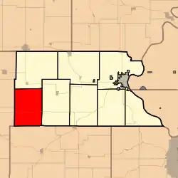 Location in Atchison County | |
| Coordinates: 39°27′30″N 095°32′01″W | |
| Country | United States |
| State | Kansas |
| County | Atchison |
| Area | |
| • Total | 47.48 sq mi (122.97 km2) |
| • Land | 47.45 sq mi (122.90 km2) |
| • Water | 0.02 sq mi (0.06 km2) 0.05% |
| Elevation | 928 ft (283 m) |
| Population (2010) | |
| • Total | 292 |
| • Density | 6/sq mi (2.4/km2) |
| GNIS feature ID | 1729699 |
Geography
Kapioma Township covers an area of 47.5 square miles (123.0 km2) and contains no incorporated settlements. According to the USGS, it contains two cemeteries: Earnst and Miller.
The streams of Catamount Creek, Elk Creek, Nebo Creek, Negro Creek and Straight Creek run through this township.
Transportation
Kapioma Township contains one airport or landing strip, Strafuss Airport.
References
- "Geographic Identifiers: 2010 Demographic Profile Data (G001): Kapioma township, Atchison County, Kansas". U.S. Census Bureau, American Factfinder. Archived from the original on February 12, 2020. Retrieved May 13, 2013.
- Ingalls, Sheffield (1916). History of Atchison County, Kansas. Standard Publishing Company. pp. 120.
External links
Municipalities and communities of Atchison County, Kansas, United States | ||
|---|---|---|
| Cities | 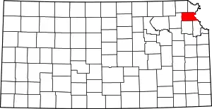 Map of Kansas highlighting Atchison County | |
| Unincorporated communities | ||
| Indian reservations | ||
| Townships | ||
| Ghost towns | ||
| Footnotes | ‡This populated place also has portions in an adjacent county or counties | |
| ||
This article is issued from Wikipedia. The text is licensed under Creative Commons - Attribution - Sharealike. Additional terms may apply for the media files.