Kapiti Coast
The Kapiti Coast (formerly known as the Golden Coast) is the name of the section of the coast of the south-western North Island of New Zealand that is north of Wellington and opposite Kapiti Island. It falls under the jurisdiction of the Wellington Regional Council.[1] About 5/6 of it (up to Waikanae) is considered suburbs of Wellington.
Geography
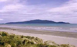
The Kapiti Coast District stretches from Paekākāriki in the south through Ōtaki in the north. It includes the towns of Te Horo, Waikanae, Paraparaumu, Raumati Beach, Ōtaki, Paekākāriki and Raumati South, and smaller localities such as Emerald Glen, Lindale, Maungakotukutuku, Otaihanga, and Peka Peka.[2] Along the thin coastal plains at the foot of the Tararua Range, the Kapiti Coast in common parlance occasionally includes the neighbouring areas south to Plimmerton to the north of Porirua Harbour, and in the north includes some of the coastal areas of Horowhenua such as Waikawa Beach and even Hokio Beach, close to Lake Horowhenua. The district extends inland to the top of the Tararua Range, whereas in the public perception the inland hill country is rarely considered as part of the coast. Kapiti is possibly most famous for its island, Kapiti Island. The island is a pest-free bird sanctuary, where a permit is required to visit.
News
The Kapiti Coast has four news sources owned and operated on the coast.
- Kapiti News - Is a Kapiti Newspaper run by New Zealand Herald and a part of NZME[3]
- BeachFM - Local owned radio station broadcasting on 106.3 FM[4]
- Whats On Kapiti - Online news source publishing about Kapiti.[5]
- Kapiti Observer - Free Kapiti newspaper delivering to homes and is run by Stuff[6]
Climate
The area has an oceanic climate with moderate temperature swings between seasons, resulting in warm summers and mild winters without any severe heat waves or cold spells.
| Climate data for Paraparaumu (1981-2010 normals) | |||||||||||||
|---|---|---|---|---|---|---|---|---|---|---|---|---|---|
| Month | Jan | Feb | Mar | Apr | May | Jun | Jul | Aug | Sep | Oct | Nov | Dec | Year |
| Record high °C (°F) | 29.0 (84.2) |
29.9 (85.8) |
30.0 (86.0) |
26.3 (79.3) |
22.6 (72.7) |
19.9 (67.8) |
19.0 (66.2) |
20.6 (69.1) |
21.7 (71.1) |
22.7 (72.9) |
25.6 (78.1) |
29.2 (84.6) |
30.0 (86.0) |
| Average high °C (°F) | 21.1 (70.0) |
21.5 (70.7) |
20.1 (68.2) |
17.7 (63.9) |
15.5 (59.9) |
13.3 (55.9) |
12.6 (54.7) |
13.2 (55.8) |
14.6 (58.3) |
15.8 (60.4) |
17.5 (63.5) |
19.5 (67.1) |
16.8 (62.2) |
| Daily mean °C (°F) | 17.3 (63.1) |
17.4 (63.3) |
15.9 (60.6) |
13.4 (56.1) |
11.6 (52.9) |
9.7 (49.5) |
8.6 (47.5) |
9.4 (48.9) |
11.0 (51.8) |
12.5 (54.5) |
13.9 (57.0) |
16.0 (60.8) |
13.0 (55.4) |
| Average low °C (°F) | 13.3 (55.9) |
13.2 (55.8) |
11.5 (52.7) |
9.1 (48.4) |
7.6 (45.7) |
6.0 (42.8) |
4.5 (40.1) |
5.5 (41.9) |
7.4 (45.3) |
9.0 (48.2) |
10.2 (50.4) |
12.3 (54.1) |
9.1 (48.4) |
| Record low °C (°F) | 3.7 (38.7) |
3.1 (37.6) |
0.8 (33.4) |
−1.0 (30.2) |
−3.3 (26.1) |
−4.4 (24.1) |
−4.8 (23.4) |
−3.5 (25.7) |
−3.8 (25.2) |
−1.7 (28.9) |
0.0 (32.0) |
2.6 (36.7) |
−4.8 (23.4) |
| Average rainfall mm (inches) | 52.7 (2.07) |
70.6 (2.78) |
59.8 (2.35) |
61.3 (2.41) |
76.1 (3.00) |
92.5 (3.64) |
75.4 (2.97) |
91.9 (3.62) |
75.8 (2.98) |
108.2 (4.26) |
72.7 (2.86) |
81.4 (3.20) |
922.3 (36.31) |
| Average rainy days (≥ 1.0 mm) | 6.5 | 6.7 | 7.4 | 7.7 | 9.6 | 12.1 | 10.6 | 11.2 | 10.8 | 11.5 | 9.1 | 10.1 | 113.3 |
| Source: Météo Climat[7][8] | |||||||||||||
History
Māori chief Te Rauparaha established a base on Kapiti Island, and from this position, he was able to launch attacks on other tribes during the Musket Wars of the early 19th century. Around this time, Europeans began whaling in the area, and on 16 October 1839, William Wakefield of the New Zealand Company arrived in the Kapiti region to purchase land for permanent European settlement. Te Rauparaha sold him land in the Nelson and Golden Bay area.
European settlement of the Kapiti Coast only took place on a significant scale after the Wellington and Manawatu Railway Company (WMR) opened its railway line from Wellington to Longburn, just south of Palmerston North. The line was opened in 1886, with the final spike driven in on the Kapiti Coast at Otaihanga. Paekākāriki was quickly established as a significant steam locomotive depot due to the need to swap locomotives at the location; powerful, heavy locomotives were required to handle trains over the rugged section from Wellington to Paekākāriki, while lighter, faster locomotives were more suited to the relatively flat terrain north of Paekākāriki. In 1908, the WMR was purchased by the New Zealand Railways Department, who incorporated the line into the North Island Main Trunk railway.[9]
In June 1940, the Wellington-Paekākāriki section was electrified as electric locomotives provided better motive power. This meant trains would swap from steam (and later diesel-electric) to electric traction in Paekākāriki and it retained its status as a significant locomotive depot. It also became the northern terminus of the Wellington commuter railway network until 8 May 1983, when it was extended to Paraparaumu. In February 2011 electrification reached Waikanae, which became the new terminus.
During World War II, Queen Elizabeth Park – a large tract of parkland between Raumati South and Paekākāriki – was the location of two United States Army and Marines camps, McKay and Russell. US troops were stationed at the camps in 1942–44 prior to being sent into combat in the Pacific Ocean theatre.
After World War II, Wellington's Rongotai Airport was closed due to safety reasons in 1947 and Kapiti Coast Airport became the main airport for the Wellington Region. In 1949, it was New Zealand's busiest airport and helped to stimulate growth on the Kapiti Coast. The Wellington International Airport was opened in 1959 and Paraparaumu Airport never regained its status, with some of its land sold for residential development in the 1990s and 2000s. It is now used for minor commercial activity such as that of airline Air Chathams, helicopter and light aircraft training and for private and hobby flights.
Recently, the Kapiti Coast has seen a significant population surge and is one of New Zealand's fastest growing areas. This has led to considerable growth in all towns apart from Paekākāriki, where development is geographically limited by the sea and steep hill sides.[10]
Economy and transport
The Kapiti Coast is well known for its cheeses and other products from Lindale. Light industry is focused in Paraparaumu and Ōtaki, with small clusters in Waikanae and Raumati.
Many of the Kapiti Coast's residents are not employed in the area. Instead, they commute to jobs in Wellington. Transdev operates electric commuter trains along a portion of the North Island Main Trunk Railway referred to as the Kapiti Line on behalf of Metlink (the Greater Wellington public transport brand), and the KiwiRail Capital Connection commuter train from Palmerston North to Wellington provides a service for commuters north of the electric terminus in Waikanae. Metlink also provides regular local bus services throughout the Kapiti Coast, operated by Uzabus.
Kapiti Coast Airport is located in Paraparaumu township. After Air New Zealand withdrew air services in April 2018, Air Chathams announced that they would be launching flights to Auckland from August 2018.[11][12] Several other small airlines operate from the airport.[13]
In February 2017 an 18 km (11 mi) long expressway diversion from Mackays Crossing north of Paekākāriki to just north of Peka Peka, was opened[14] to enable State Highway 1 to bypass developed urban areas. An extension to Ōtaki is expected to open in 2020.
Film and television
The Kapiti Coast area has also made appearances in television and film. Peter Jackson (of Lord of the Rings and King Kong fame) is from Pukerua Bay and went to high school at Kapiti College in Raumati Beach. Scenes from both of the aforementioned movies have been filmed on the Kapiti Coast. During the filming of The Lord of the Rings: The Return of the King, some of the seminal battle scenes in the fields in front of Minas Tirith were shot in part at Queen Elizabeth Park. Kapiti Island figured in King Kong with the scenes approaching the lost island of King Kong shot in the waters between Raumati Beach and the island.
Andrew Niccol, a screenwriter and film producer, was born in Paraparaumu. He has written and produced (or co-produced) a number of movies, including Gattaca, The Truman Show, S1m0ne and Lord of War. Also from Paraparaumu is young actor James Ashcroft who has acted in numerous TV productions, including occasional appearances in Battlestar Galactica.
Sport
A number of rugby union clubs are based in the area, including Paraparaumu RFC, Waikanae RFC, Rahui RFC, and Toa RFC. Horowhenua Kapiti represent the district in the Heartland Championship.
Kapiti has been represented in rugby league by the Kapiti Bears – Kapiti Coast Rugby League Club Inc. The Club was founded in the 1970s and was the home of Kiwi and Melbourne Storm player Stephen Kearney. The Kapiti Bears operate out of Matthews Park, Menin Road, and are affiliated with the Wellington Rugby League Association.
In association football, Kapiti is represented by Kapiti Coast United, who play at Weka Park in Raumati Beach. The club was formed by the merger of Raumati Hearts and Paraparaumu United in 2003.
Paraparaumu Track and Field Club is the athletics club based in Paraparaumu, with facilities at the Paraparaumu Domain.
Attractions
- Kapiti Island is an iconic landmark, providing a symbol for a number of local businesses and groups. The island has several walks and trails, and contains species of protected native birdlife. Access to the nature reserve is by approved tour groups only.[15]
- The Kapiti Coast Museum is located in Waikanae. It has a wide range of historic collections including object and clothing displays, archives, hands-on exhibits, a reconstruction of a historic Kapiti Coast domestic layout, plus military and 19th century communications equipment.[16]
- Ōtaki-Māori Racing Club is New Zealand's only Māori racing club; it was formed in 1886, and holds eight race meetings annually.[17]
- New Zealand artist Shona Moller has her studio and gallery located on Paraparaumu Beach.
- Queen Elizabeth Park contains the Wellington Tramway Museum and a number of coastal walking tracks. It also hosts orienteering events.
- Paekakariki Station Museum is Administered by the Paekakariki Station Precinct Trust. The museum has displays of local Maori and Heritage items along with sections devoted to Railways and the US Marines occupation of the McKays Crossing area during World War II. Free Admission but donations are greatly appreciated. Facilities include toilets and wheelchair access. Morning and Afternoon teas can be arranged for special occasions and Group Visits. Located in the Historic Paekakariki Railway Station Building on the main platform.
- Steam Incorporated, a railway preservation society, is based in the Paekakariki Railway Yard. Steam Inc.'s depot, known as "The Engine Shed", where locomotives and rolling stock are restored and displayed, and the society is also one of the few operators of steam-hauled excursions on New Zealand's national railway network.[18]
- One of the Southern Hemisphere's largest car collections is at the Southward Car Museum in Otaihanga, and a popular ridable miniature railway operates in Raumati Marine Gardens.
- Paekakariki Escarpment Walkway[19] is a walking track that goes between Paekākāriki and Pukerua Bay Station.[20] It is part of Te Araroa walkway that traverses New Zealand from north to south.
References
- Guide, New Zealand Tourism. "Kapiti Coast New Zealand, Kapiti Coast Travel, Tourism, Accommodation, Island, Wellington, NZ". www.tourism.net.nz. Retrieved 5 March 2018.
- "Geography notes | Kāpiti Coast District | profile.id". profile.idnz.co.nz. Retrieved 5 March 2018.
- "NZME brands". advertising.nzme.co.nz. Retrieved 3 March 2018.
- "Beach FM 106.3 Radio Stations Kapiti | Yellow® NZ". yellow.co.nz. Retrieved 5 March 2018.
- "About Us - Whats On Kapiti". Whats On Kapiti. Retrieved 8 March 2018.
- "Kapiti Observer (Stuff)". News Works. Retrieved 27 June 2019.
- "Météo climat stats for Paraparaumu". Météo Climat. Retrieved 25 March 2017.
- "Météo climat stats Records for Paraparaumu". Météo Climat. Retrieved 25 March 2017.
- "The History of Kapiti". www.kapitinow.co.nz. Retrieved 5 March 2018.
- "District History - Kapiti Coast District Council". www.kapiticoast.govt.nz. Retrieved 5 March 2018.
- "Air New Zealand suspends Kapiti Coast service". Air New Zealand. 9 March 2018. Retrieved 23 July 2018.
- L, Steve (2 July 2018). "Kapiti Air Service to Start 20 August". 3rd Level New Zealand. Retrieved 23 July 2018.
- "Kapiti Coast Airport Holdings Ltd - About Kapiti Coast Airport". www.kapiticoastairport.co.nz. Archived from the original on 27 January 2018. Retrieved 5 March 2018.
- Haxton, David (16 February 2017). "Mackays to Peka Peka Expressway north of Wellington opens". nzherald.co.nz (via Kapiti News). Retrieved 17 February 2017.
- (DOC), corporatename = New Zealand Department of Conservation. "Kapiti Island Nature Reserve". www.doc.govt.nz. Retrieved 5 March 2018.
- http://www.kapiticoastmuseum.org.nz/collections/
- "Ōtaki-Māori Racing Club". www.otakimaoriracing.co.nz. Retrieved 9 April 2018.
- "History | Steam Inc". www.steaminc.org.nz. Retrieved 5 March 2018.
- "Things to Do in Kapiti Coast". Trip Adviser.
- "Paekakariki escarpment | Tracks.org.nz". tracks.org.nz. Retrieved 25 February 2018.