Paraparaumu
Paraparaumu (Māori: [ˈpaɾapaˈɾaʉmʉ])[1] is a town in the south-western North Island of New Zealand. It lies on the Kapiti Coast, 55 kilometres (34 mi) north of the nation's capital city, Wellington.
Paraparaumu | |
|---|---|
Town | |
| Coordinates: 40°55′S 175°01′E | |
| Country | New Zealand |
| Region | Wellington |
| Territorial authority | Kapiti Coast District |
| Population (June 2020) | |
| • Total | 30,100 |
| Postcode(s) | 5032 |
| Area code(s) | 04 |
Like other towns in the area, it has a partner settlement at the coast called Paraparaumu Beach, which lies directly opposite Kapiti Island. The two towns form part of the Kapiti Coast District. Together with the nearby Raumati Beach and Raumati South they are among the fastest-growing urban areas in New Zealand, and are major dormitory towns with workers commuting to the cities that make up the Wellington urban area. The four towns between them have a 2012 population of over 49,000 people.[2] Inland behind Paraparaumu is the Maungakotukutuku area.
"Paraparaumu" is a Māori-language name meaning "scraps from an earth oven"; "parapara" means "dirt" or "scraps", and "umu" means "oven".[3]
The village of Lindale is a located just north of the Paraparaumu town centre. It began as a Tourist and Agricultural Centre, but later gained a reputation for cheese and the Lindale Barnyard petting farm.[4][5][6]
The old State Highway 1 and the North Island Main Trunk railway both pass through Lindale. The railway line was formerly owned by the Wellington and Manawatu Railway Company, and construction of the line was completed when the ends from Wellington and Longburn (Palmerston North) met near Lindale in Otaihanga in 1886. There are proposals to extend the commuter train service, operated by Transdev Wellington to a new station at Lindale, subject to Wellington Regional Council funding.[7]
Climate
Paraparaumu has an oceanic climate typical of New Zealand, with moderately warm summers and mild winters. It has a quite high rainfall frequency year round, although it is drier than many other coastal areas in the country.
| Climate data for Paraparaumu (1981-2010 normals) | |||||||||||||
|---|---|---|---|---|---|---|---|---|---|---|---|---|---|
| Month | Jan | Feb | Mar | Apr | May | Jun | Jul | Aug | Sep | Oct | Nov | Dec | Year |
| Record high °C (°F) | 29.0 (84.2) |
29.9 (85.8) |
30.0 (86.0) |
26.3 (79.3) |
22.6 (72.7) |
19.9 (67.8) |
19.0 (66.2) |
20.6 (69.1) |
21.7 (71.1) |
22.7 (72.9) |
25.6 (78.1) |
29.2 (84.6) |
30.0 (86.0) |
| Average high °C (°F) | 21.1 (70.0) |
21.5 (70.7) |
20.1 (68.2) |
17.7 (63.9) |
15.5 (59.9) |
13.3 (55.9) |
12.6 (54.7) |
13.2 (55.8) |
14.6 (58.3) |
15.8 (60.4) |
17.5 (63.5) |
19.5 (67.1) |
16.8 (62.2) |
| Daily mean °C (°F) | 17.3 (63.1) |
17.4 (63.3) |
15.9 (60.6) |
13.4 (56.1) |
11.6 (52.9) |
9.7 (49.5) |
8.6 (47.5) |
9.4 (48.9) |
11.0 (51.8) |
12.5 (54.5) |
13.9 (57.0) |
16.0 (60.8) |
13.0 (55.4) |
| Average low °C (°F) | 13.3 (55.9) |
13.2 (55.8) |
11.5 (52.7) |
9.1 (48.4) |
7.6 (45.7) |
6.0 (42.8) |
4.5 (40.1) |
5.5 (41.9) |
7.4 (45.3) |
9.0 (48.2) |
10.2 (50.4) |
12.3 (54.1) |
9.1 (48.4) |
| Record low °C (°F) | 3.7 (38.7) |
3.1 (37.6) |
0.8 (33.4) |
−1.0 (30.2) |
−3.3 (26.1) |
−4.4 (24.1) |
−4.8 (23.4) |
−3.5 (25.7) |
−3.8 (25.2) |
−1.7 (28.9) |
0.0 (32.0) |
2.6 (36.7) |
−4.8 (23.4) |
| Average rainfall mm (inches) | 52.7 (2.07) |
70.6 (2.78) |
59.8 (2.35) |
61.3 (2.41) |
76.1 (3.00) |
92.5 (3.64) |
75.4 (2.97) |
91.9 (3.62) |
75.8 (2.98) |
108.2 (4.26) |
72.7 (2.86) |
81.4 (3.20) |
922.3 (36.31) |
| Average rainy days (≥ 1.0 mm) | 6.5 | 6.7 | 7.4 | 7.7 | 9.6 | 12.1 | 10.6 | 11.2 | 10.8 | 11.5 | 9.1 | 10.1 | 113.3 |
| Source: Météo Climat[8][9] | |||||||||||||
Demographics
The Paraparaumu urban area had a usual resident population of 28,701 at the 2018 New Zealand census, an increase of 1,863 people (6.9%) since the 2013 census, and an increase of 3,441 people (13.6%) since the 2006 census. There were 13,563 males and 15,135 females, giving a sex ratio of 0.90 males per female. Of the total population, 5,208 people (18.1%) were aged up to 15 years, 4,296 (15.0%) were 15 to 29, 12,486 (43.5%) were 30 to 64, and 6,708 (23.4%) were 65 or older.[10]
In terms of ethnicity, 89.1% were European/Pākehā, 12.5% were Māori, 3.1% were Pacific peoples, 5.1% were Asian, and 2.3% were other ethnicities (totals add to more than 100% since people could identify with multiple ethnicities).[10]
| SA2 name | Population | Dwellings | Median age | Median income |
|---|---|---|---|---|
| Otaihanga | 804 | 327 | 46.3 years | $37,800 |
| Paraparaumu Beach East | 2,667 | 1,173 | 49.9 years | $27,900 |
| Paraparaumu Beach North | 4,056 | 1,608 | 42.1 years | $32,300 |
| Paraparaumu Beach West | 2,364 | 1,218 | 50.5 years | $31,400 |
| Paraparaumu Central | 3,996 | 1,824 | 44.8 years | $26,300 |
| Paraparaumu East | 2,265 | 867 | 41.7 years | $25,700 |
| Paraparaumu North | 3,555 | 1,545 | 49.8 years | $29,300 |
| Raumati Beach East | 2,376 | 1,026 | 47.2 years | $27,100 |
| Raumati Beach West | 2,865 | 1,326 | 45.8 years | $36,800 |
| Raumati South | 3,753 | 1,572 | 42.8 years | $36,900 |
Economy
Sport
Paraparaumu was formerly represented in soccer by Paraparaumu United. They merged with the Raumati Hearts in 2003 to create Kapiti Coast United, which is based at Weka Park in Raumati.
The local athletics club is Paraparaumu Track and Field Club, which has both junior and senior members in conjunction with Athletics Wellington and Athletics New Zealand age grades. The club is based at the Paraparaumu Domain.[14]
Transport
Airport
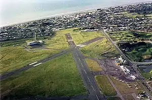
Kapiti Coast Airport has a few scheduled commercial flights and is a popular recreational airfield, hosting the Kapiti Aero Club. Air Chathams will have daily flights between the airport and Auckland from 20 August 2018,[15] and Sounds Air operate to Blenheim and Nelson. Now defunct, locally based Air2there used operate to Blenheim and Nelson also.
Public transport
Paraparaumu is located on the North Island Main Trunk Railway (NIMT), on the Kapiti Line of Wellington's commuter railway network operated by Transdev under the Metlink brand. Electrified commuter services were extended to Waikanae on 20 February 2011. Korean built by Hyundai Rotem, FP/FT class electric multiple units operate the commuter trains.
Beyond Waikanae, KiwiRail's Tranz Scenic operates two diesel-hauled long distance passenger services: the Capital Connection between Palmerston North and Wellington, and the Northern Explorer between Auckland and Wellington. Both trains stop at Paraparaumu. There are also feeder and local commuter bus services.
Education
Primary schools
Paraparaumu Beach School is a co-educational state primary school for Year 1 to 8 Students with a roll of 682 students. [16]
Kapiti School is a co-educational state primary school for Year 1 to 8 students,[17][18] with a roll of 204 as of March 2020.[19]
Kenakena School is a co-educational state primary school for Year 1 to 8 students,[20][21] with a roll of 541.[22]
Our Lady of Kapiti School is a co-educational state-integrated Catholic primary school for Year 1 to 8 students,[23][24] with a roll of 203.[25]
Secondary schools
Three secondary schools are located near the Paraparaumu township: Paraparaumu College in Paraparaumu Beach, Kapiti College in Raumati Beach and Otaki College in Ōtaki.
Notable residents
Born in Paraparaumu
- Christian Cullen – Rugby union footballer
- Stephen Kearney – Rugby league footballer and coach
- Wayne McIndoe – Field hockey player
- Drew Neemia – C4's Select Live host
- Andrew Niccol – Film director
Educated in Paraparaumu
- Peter Jackson at Kapiti College – Film Director
- Dane Coles at Paraparaumu College - All Blacks Player
- Karl Kippenberger at Kapiti College - Bass Player Shihad
Notes
- /ˌpærəpəˈraʊmuː/, thouɡh typically pronounced /ˌpærəˌpærəˈuːmuː/. In Maori vowels are run together, even when they are brought together by the creation of compound words. See for example
- Kapiti Coast Distinct Council, Community Profile Archived 2008-10-14 at the Wayback Machine
- Chris Maclean, "Wellington Places – Kapiti Coast", Te Ara
- Weblog NZ feature, April 2003
- OSNZ - Breeding biology of little shags (Phalacrocorax melanoleucos) at Lindale
- Lindale Village
- Scoop - Lindale Bridge nearly finished, October 2004
- "Météo climat stats for Paraparaumu". Météo Climat. Retrieved 25 March 2017.
- "Météo climat stats Records for Paraparaumu". Météo Climat. Retrieved 25 March 2017.
- "Age and sex by ethnic group (grouped total response), for census usually resident population counts, 2006, 2013, and 2018 Censuses (urban rural areas)". nzdotstat.stats.govt.nz. Retrieved 2020-09-13.
- "2018 Census place summaries | Stats NZ". www.stats.govt.nz. Retrieved 2020-12-14.
- "Coastlands History". coastlands.co.nz. Coastlands Shoppingtown Ltd.
- "Coastlands - Stores". coastlands.co.nz. Coastlands Shoppingtown.
- https://sitedesq.sportstg.com/index.cfm?fuseaction=Display_Page&PageID=11971&OrgID=10494
- "Air Chathams will pick up Paraparaumu to Auckland flight route". NZ Herald. Retrieved 2 July 2018.
- "Paraparaumu Beach School Government Report". ero.govt.nz.
- "Kapiti School Official School Website". kapiti.school.nz.
- "Kapiti School Ministry of Education School Profile". educationcounts.govt.nz. Ministry of Education.
- "Kapiti School Education Review Office Report". ero.govt.nz. Education Review Office.
- "Kenakena School Official School Website". kenakena.school.nz.
- "Kenakena School Ministry of Education School Profile". educationcounts.govt.nz. Ministry of Education.
- "Kenakena School Education Review Office Report". ero.govt.nz. Education Review Office.
- "Our Lady of Kapiti School Official School Website". stpatspara.school.nz.
- "Our Lady of Kapiti School Ministry of Education School Profile". educationcounts.govt.nz. Ministry of Education.
- "Our Lady of Kapiti School Education Review Office Report". ero.govt.nz. Education Review Office.