Kapiti Island
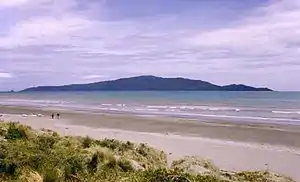
Kapiti Island is an island about 5 km (3 mi) off the west coast of the lower North Island of New Zealand. It is 10 kilometres (6.2 mi) long, running southwest/northeast, and roughly 2 kilometres (1.2 mi) wide, being more or less rectangular in shape, and has an area of 19.65 km2 (7.59 sq mi).
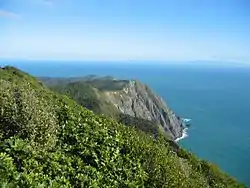 Looking south from Kapiti Island. | |
 Kapiti Island | |
| Geography | |
|---|---|
| Location | Tasman Sea |
| Coordinates | 40°52′S 174°54′E |
| Area | 19.65 km2 (7.59 sq mi) |
| Length | 8 km (5 mi) |
| Width | 2 km (1.2 mi) |
| Highest elevation | 521 m (1709 ft) |
| Highest point | Tuteremoana |
| Administration | |
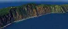
The island is separated from the North Island by the Rauoterangi channel. The highest point on the island is Tuteremoana, 521 m (1,709 ft). The seaward (west) side of the island is particularly rocky and has high cliffs, some hundreds of metres high, that drop straight into the sea. The cliffs are subject to very strong prevailing westerly winds and the scrubby vegetation that grows there is low and stunted by the harsh environmental conditions. A cross-section of the island would show almost a right-angled triangle, revealing its origins from lying on a fault line (part of the same ridge as the Tararua Range).
The island's vegetation is dominated by scrub and forest of kohekohe, tawa, and kanuka. Most of the forest is regenerating after years of burn-offs and farming, but some areas of original bush with 30 m (98 ft) trees remain.
Its name has been used since 1989 by the Kapiti Coast District Council, which includes towns such as Paekakariki, Raumati South, Paraparaumu and Waikanae.
History
The full Māori name of the island is "Te Waewae-Kapiti-o-Tara-rāua-ko-Rangitāne" (which, despite popular misconception, is unrelated to the Maori word "Kāpiti" (cabbage)).[1]
The island was surveyed in 1770 during the first voyage of James Cook.[2] In the 18th and 19th centuries Māori settled on the island. Te Rauparaha formed a base here, and his Ngāti Toa tribe regularly sailed in canoes on raiding journeys up to the Whanganui River and down to Marlborough. In the Battle of Wairo (1824) the Ngāti Toa destroyed a force of 2,000 mainland warriors who had landed at the northern end of Kapiti in an attempt to capture the island.
The sea nearby was a nursery for whales, and during whaling times 2,000 people were based on the island. Oil was melted from the blubber and shipped to America for use in machinery before petroleum was used. Although whales can be seen once every year during birthing season, there still are fewer than there used to be.
The conservation potential of the island was seen as early as 1870. It was reserved as a bird sanctuary in 1897. In 1934, an many oiled and dead birds were discovered on the island after an oil spill or dumping event.[3] It was not until 1987 that the Department of Conservation (DOC) took over the administration of the island. In the 1980s and 1990s efforts were made to return the island to a natural state; first sheep and possums were removed. In an action few thought possible for an island of its size, rats were eradicated in 1998.
In 2003 the anonymous Biodiversity Action Group claimed to have released 11 possums on the island. No evidence of the introduced possums has been found.[4]
Present day
The island is the site of Kapiti Island Nature Reserve and adjoins the Kapiti Marine Reserve. Most of it is in New Zealand Crown ownership.[5]
The island is home to a number of native birds, mostly re-introduced. These include takahe, North Island kōkako, brown teal, stitchbird (hihi), North Island saddleback (tieke), tomtit (miromiro), fantail (piwakawaka), morepork (ruru), weka and North Island robin (toutouwai). The brown kiwi and little spotted kiwi were released on the island between 1890 and 1910, and the island is now the stronghold for the latter species.[6] Rat eradication has led to increases in red-fronted parakeets, North Island robin, bellbirds, and saddlebacks and the island is considered one of New Zealand's most important sites for bird recovery, as well as a major breeding site, for seabirds. In April 2005, the critically endangered short-tailed bat was introduced to the island from a threatened population in the Tararuas, providing them with a separate, safer habitat.
Owing to the proximity of Wellington, there are regular tourist trips to the island, limited to 160 people per day, and it is an especially popular destination for birdwatchers. Having no natural mammalian predators, New Zealand birds are trusting, and a visitor to the island is likely to be rewarded by seeing a number of different species.
On 14 June 2007, one of the buildings at the Department of Conservation ranger station caught fire, sparking a major emergency operation to prevent the spread of fire to the native bush. Thirty firefighters were flown to the island and managed to contain the blaze, preventing serious damage to the ecosystem.[7]
A stoat, an introduced mustelid responsible for decimating the bird life in New Zealand, was seen on the island in December 2010, and by August the next year the Department of Conservation had killed three of them. It is thought that they could not have swum the five-kilometre stretch of open sea from the Kapiti Coast.[8]
Kapiti Island is one of Wellington region's “coastal habitats of significance for indigenous birds”. It provides predator free nesting habitat to little blue penguins, red-billed gulls, white-fronted terns and the reef heron. A further four Nationally Threatened or At Risk species occur on the coast of Kapiti Island including the Black shag, the Caspian tern, the pied shag and the variable oystercatcher.[9]
See also
References
- "Kapiti Island". Land Information New Zealand. 20 January 2020. Retrieved 20 January 2020.
- Hare, McLintock, Alexander; Wellington., Judith Sidney Hornabrook, M.A., National Archives; Taonga, New Zealand Ministry for Culture and Heritage Te Manatu. "KAPITI ISLAND". teara.govt.nz. Retrieved 30 May 2018.
- "NEW ZEALAND". Weekly Times (Melbourne, Vic. : 1869 - 1954). 11 August 1934. p. 8. Retrieved 22 April 2020.
- Beston, Anne; NZPA (14 January 2003). "Hunters the hunted in Kapiti sabotage". NZHerald. Retrieved 20 January 2020.
- "Kāpiti Island" (PDF). Greater Wellington Regional Council. Retrieved 20 January 2020.
- Denny, Edward. "Kapiti Island Nature Reserve". Atlas Obscura. Retrieved 20 January 2020.
- Blundell, Kay (15 June 2007). "Mass effort to quell Kapiti Island fire". Dominion Post. Retrieved 20 January 2020.
- Blundell, Kay (27 August 2011). "Kapiti Island: Stoat Finds Threat To Kiwi". The Dominion Post. Archived from the original on 25 March 2012.
- McArthur, Nikki; Ray, Samantha; Crowe, Patrick; Bell, Mike (20 August 2019). A baseline survey of the indigenous bird values of the Wellington region coastline (PDF). p. 47.
Further reading
- Maclean, Chris (1999). Kapiti. Whitcombe Press. ISBN 978-0-473-06166-1.
External links
| Wikimedia Commons has media related to Kapiti Island. |
- Kapiti Island Nature Reserve, Department of Conservation
- Short-tailed bat translocation project
- Kapiti Marine Reserve