Karitinden
Karitinden is a mountain in the Tafjordfjella mountain range inside Reinheimen National Park on the border of Innlandet and Møre og Romsdal counties in Norway. The top of the mountain is a tripoint border junction for Skjåk Municipality (in Innlandet county), and Fjord Municipality and Rauma Municipality (in Møre og Romsdal county). The nearest village is Tafjord which lies 17 kilometres (11 mi) to the northwest. The lake Tordsvatnet lies 4 kilometres (2.5 mi) southeast of the mountain and the mountain Puttegga lies 4 kilometres (2.5 mi) to the northwest.[1]
| Karitinden | |
|---|---|
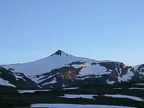 View of Karitinden | |
| Highest point | |
| Elevation | 1,982 m (6,503 ft) |
| Prominence | 330 m (1,080 ft) |
| Coordinates | 62°11′05″N 07°44′04″E |
| Geography | |
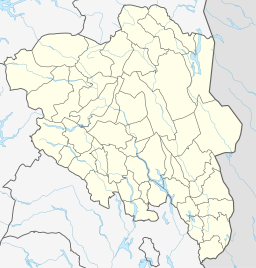 Karitinden Location of the mountain  Karitinden Karitinden (Møre og Romsdal)  Karitinden Karitinden (Norway) | |
| Location | Fjord and Rauma (Møre og Romsdal) and Skjåk (Innlandet) Norway |
| Parent range | Tafjordfjella |
| Topo map | 1319 II Tordsvatnet |
| Climbing | |
| Easiest route | Hiking |
Name
The first element is the female name Kari and the last element is the finite form of tind which means "mountain peak". The reason for the name, and who the person Kari was, is unknown.
See also
References
- "Karitinden" (in Norwegian). yr.no. Retrieved 2010-10-15.
This article is issued from Wikipedia. The text is licensed under Creative Commons - Attribution - Sharealike. Additional terms may apply for the media files.
