Puttegga
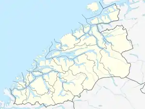
Puttegga or Pyttegga is the highest mountain in Møre og Romsdal county, Norway. It lies on the border of Fjord Municipality and Rauma Municipality. It is located just 4 kilometres (2.5 mi) northwest of the mountain Karitinden, inside Reinheimen National Park. The nearest village is Tafjord, 14 kilometres (8.7 mi) to the west. The mountain is easily accessed from the cabin Pyttbua to the east, which is maintained by the Norwegian Trekking Association.[2]
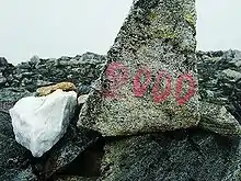
Painted on the summit by people wanting a 2K-summit in Møre og Romsdal
| Puttegga | |
|---|---|
| Pyttegga | |
 Puttegga Location of the mountain  Puttegga Puttegga (Norway) | |
| Highest point | |
| Elevation | 1,999 m (6,558 ft) |
| Prominence | 570 m (1,870 ft) |
| Isolation | 26.75 to 26.77 km (16.62 to 16.63 mi) |
| Listing | #4 at List of highest points of Norwegian counties |
| Coordinates | 62.2119°N 7.6956°E[1] |
| Geography | |
| Location | Møre og Romsdal, Norway |
| Parent range | Tafjordfjella |
| Topo map | 1319 III Tafjord |
Name
The first element is putt or pytt, meaning "puddle" or "small lake". The last element is the finite form of egg which means "edge" or "mountain ridge". The edge is surrounded by several small lakes.
References
- "Puttegga, Norddal (Møre og Romsdal)" (in Norwegian). yr.no. Retrieved 2019-07-06.
- Store norske leksikon. "Pyttegga" (in Norwegian). Retrieved 2010-10-15.
This article is issued from Wikipedia. The text is licensed under Creative Commons - Attribution - Sharealike. Additional terms may apply for the media files.
