Karrinyup Road
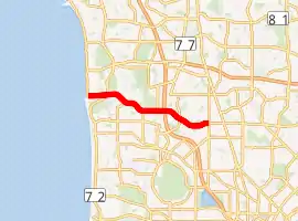
Karrinyup Road is a major east-west road in the inner northern suburbs of Perth, Western Australia, connecting the City of Stirling council offices, Osborne Park Hospital and Karrinyup Shopping Centre with residential estates in Innaloo, Stirling and Balcatta. The road, especially the portion between the Freeway and Main Street, was one of the first roads in the area, known as Balcatta Beach Road and later as North Beach Road. Until the 1990s, most of this stretch of the road was still fledged by functioning market gardens.
Karrinyup Road | |
|---|---|
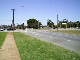 | |
Looking east towards Francis Avenue in Karrinyup | |
| |
| General information | |
| Type | Highway |
| Length | 8.0 km (5.0 mi) |
| Opened | 1950s |
| Route number(s) | |
| Tourist routes | |
| Major junctions | |
| West end | |
| |
| East end | |
| Location(s) | |
| Major suburbs | Karrinyup, Stirling |
| Highway system | |
For part of 1984, Karrinyup Road was the end point of the Mitchell Freeway. Prior to the freeway's construction, this intersection was the crossing point of Odin Road between Innaloo and the Balcatta industrial area.
Main Roads Western Australia controls and maintains Karrinyup Road.[1] It is part of Main Roads' internal designation H28 Karrinyup–Morley Highway, along with Morley Drive.[2]
Major intersections
 West Coast Drive (Tourist Drive 204), Trigg
 Marmion Avenue (State Route 71) north / West Coast Highway (State Route 71 / Tourist Drive 204) south, Trigg and Karrinyup
- Francis Avenue, Karrinyup (at Karrinyup Shopping Centre)
- Huntriss Road, Karrinyup, Gwelup and Innaloo
- North Beach Road, Gwelup and Innaloo
 Mitchell Freeway (State Route 2), Gwelup, Innaloo and Stirling
 Cedric Street (State Route 64), Stirling
 Morley Drive (State Route 76) east / Main Street north and south, Balcatta
See also
![]() Australian Roads portal
Australian Roads portal
References
- Main Roads Western Australia (29 October 2013). "Metropolitan Roads". Government of Western Australia. Retrieved 24 December 2013.
- Main Roads Western Australia (28 February 2011). "Metropolitan Network" (Map). Intergrated Service Arrangement. 1:500,000. Government of Western Australia. Archived from the original (PDF) on 3 August 2013. Retrieved 24 December 2013.
| |||||
| National Highways | |||||
| National Routes | |||||
| State Routes | |||||
| Tourist Drives | |||||