Karrinyup, Western Australia
Karrinyup is a suburb of Perth, the capital city of Western Australia, and is located 12 km north of Perth's central business district. Its local government area is the City of Stirling.
| Karrinyup Perth, Western Australia | |||||||||||||||
|---|---|---|---|---|---|---|---|---|---|---|---|---|---|---|---|
 Karrinyup Bus Station (Transperth) | |||||||||||||||
 Karrinyup Location in metropolitan Perth | |||||||||||||||
| Coordinates | 31.875°S 115.777°E | ||||||||||||||
| Population | 9,283 (2016 census)[1] | ||||||||||||||
| • Density | 1,428/km2 (3,699/sq mi) | ||||||||||||||
| Established | 1950s | ||||||||||||||
| Postcode(s) | 6018 | ||||||||||||||
| Area | 6.5 km2 (2.5 sq mi) | ||||||||||||||
| Location | 12 km (7 mi) from Perth | ||||||||||||||
| LGA(s) | City of Stirling | ||||||||||||||
| State electorate(s) | Carine | ||||||||||||||
| Federal Division(s) | Stirling Curtin | ||||||||||||||
| |||||||||||||||
History
The name Karrinyup was originally derived from the word Careniup, a Noongar name for a nearby swamp, an Aboriginal word apparently meaning "the place where bush kangaroos graze". In the 1840s, Samuel Moore took up a grant of 780 acres (3.2 km2) in the northern part of the suburb. Moore's grant, Swan Location 92 was surveyed by P Chauncey in 1844 and Chauncey recorded a large swamp just to the east of Karrinyup as Careniup Swamp.[2]
In 1929, the foundation committee developing the Lake Karrinyup Country Club golf course opted to change the spelling.[3]
While the area had been subdivided by Charles Stoneman in 1904 and roads built, the country club remained the only significant feature in the area, and rapid growth did not begin until 1957, with the part south of Karrinyup Road developing first. At this stage, the only access to the area from Perth was via Wanneroo Road and Balcatta Beach Road. The building of the Mitchell Freeway to Karrinyup Road in 1983-84 facilitated the growth of Karrinyup and nearby Stirling as a regional hub.
Geography
Karrinyup is bounded by North Beach Road to the north (Reid Highway is located just a few hundred metres further north), Marmion Avenue to the west, Newborough Street to the south and Huntriss Road and the country club to the east. About one-third of Karrinyup's land area is reserve or bushland, or part of the suburb's two golf courses. Karrinyup Road links Marmion Avenue and West Coast Highway to Mitchell Freeway through the suburb.[4]
At the 2016 Australian census, Karrinyup had a population of 9,283.[1] Most of the houses in Karrinyup are relatively modern, though the prolonged period of development has resulted in a range of styles from various eras. Many of the homes within the suburb are of two storeys and the vast majority are of brick and tile construction.
Facilities
The Karrinyup Shopping Centre contains a bus station, community centre and library as well as two major department stores. It was built in 1973 and has since been extended to offer 54,587 m² of retail accommodation with undercover and open-air parking. A major renovation is expected to be finished in 2021, with plans for apartment towers in the north-east of the complex. It's owned by the superannuation fund Unisuper and managed by AMP.
Karrinyup has two golf courses, Hamersley (public) and Lake Karrinyup (private). Open spaces exist at Lake Karrinyup and at the south-west of the suburb. Karrinyup contains three state primary schools (Karrinyup, Deanmore and Newborough) and a private college, St Mary's Anglican Girls' School, founded in 1921 at West Perth and relocated to Karrinyup in 1961.
Transport
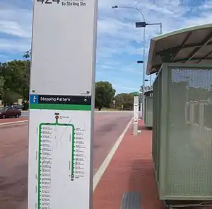
Karrinyup is served by the Karrinyup bus station, located at the shopping centre, with Transperth bus routes 422, 423, 424 and 425 providing a link to Stirling train station.[5] Further west is a bus depot operated by Swan Transit. All services are operated by Swan Transit.
Politics
Karrinyup is a reasonably affluent suburb with many "mortgage belt" families and socially liberal voters. It consistently supports the Liberal Party at both federal and state elections, although the part south of Karrinyup Road leans more towards the Australian Labor Party.
|
|
| ||||||||||||||||||||||||||||||||||||||||||||||||||||||
|
| |||||||||||||||||||||||||||||||||||||||||||||||||||||||
Notable residents
- Peter Dowding, former Premier of Western Australia (1988 to 1990)
- Dennis Lillee, former Australian cricketer[6]
- Emma Matthews, soprano
- Jeff Newman, former television presenter
- Tim Winton, novelist and National Living Treasure, grew up in Gwelup Street[7][8]
References
- Australian Bureau of Statistics (27 June 2017). "State Suburbs: Karrinyup". 2016 Census QuickStats. Retrieved 19 June 2019.

- Western Australian Land Information Authority. "History of metropolitan suburb names – K". Retrieved 17 April 2007.
- City of Stirling. "Suburbs - Karrinyup". Archived from the original on 18 September 2006. Retrieved 15 September 2006.
- Department of Land Information. StreetSmart Perth Street Directory (48 (2007) ed.). West Australian Newspapers Ltd. Maps 310–311. ISBN 1-921048-10-7.
- Northern 62 timetable Archived 30 September 2007 at the Wayback Machine, Transperth, effective 8 August 2005. Accessed 17 January 2007.
- Ryan, Christian (May 2015). "The thirty-ninth summer of DK Lillee". The Cricket Monthly. Retrieved 6 February 2020.
- McGirr, Michael (1999). Tim Winton: The Writer and His Work. South Yarra, Victoria: Macmillan. p. 4. ISBN 9780732955885. Retrieved 6 February 2020.
- Forbes, Malcolm (11 August 2018). "Author Tim Winton: 'If there's no trouble, there's no story'". The National. Abu Dhabi. Retrieved 6 February 2020.
External links
| Coastal |  | |
|---|---|---|
| Central | ||
| South Eastern | ||
¹ Suburb shared with other local government areas | ||