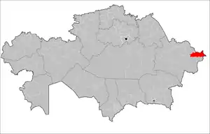
Katonkaragay District
Katonkaragay, also spelled Katon-Karagay (Kazakh: Қатонқарағай ауданы, romanized: Qatonqaraǵaý aýdany) is a district of East Kazakhstan Region in eastern Kazakhstan. The administrative center of the district is the selo of Ulken Narym (Bolshenarymskoye) (49°12′41″N 84°30′50″E[2]) (Kazakh: Үлкен Нарым ауылы, romanized: Ylken Narym auyly).[3] It is the easternmost district in Kazakhstan. Population: 28,008 (2013 estimate);[1] 30,056 (2009 Census results);[4] 45,149 (1999 Census results).[4]
Katonkaragay | |
|---|---|
District | |
| Катонқарағай ауданы Катон-Карагайский район | |
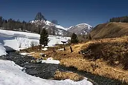 Kara-Koba River, Markakol Nature Reserve | |
 | |
| Coordinates: 49.2113°N 84.5138°E | |
| Country | |
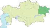
| Region | East Kazakhstan Region |
| Administrative center | Ulken Narym |
| Founded | 1928 |
| Area | |
| • Total | 13,167 km2 (5,084 sq mi) |
| Population (2013)[1] | |
| • Total | 28,008 |
| Time zone | UTC+6 (East) |
Near the selo of Berel (49°22′24″N 86°26′17″E[5]) excavations of ancient burial mounds have revealed artefacts the sophistication of which are encouraging a revaluation of the nomadic cultures of the 3rd and 4th centuries BC.[6]
References
- "Население Республики Казахстан" (in Russian). Департамент социальной и демографической статистики. Retrieved 27 December 2013.
- https://web.archive.org/web/20070623042356/http://wikimapia.org/#y=33760882&x=7823639&z=7&l=0&m=a&v=2. Archived from the original on June 23, 2007. Retrieved March 13, 2012. Missing or empty
|title=(help) - "Subdivisions of Kazakhstan in local languages". Geonames.de. Archived from the original on 2016-03-03. Retrieved 2014-02-28.
- "Население Республики Казахстан" (in Russian). Департамент социальной и демографической статистики. Retrieved 8 December 2013.
- Archived June 23, 2007, at the Wayback Machine
- "Artifacts Show Sophistication of Ancient Nomads". The New York Times. Retrieved 2014-03-01.
This article is issued from Wikipedia. The text is licensed under Creative Commons - Attribution - Sharealike. Additional terms may apply for the media files.