Regions of Kazakhstan
Kazakhstan is divided into 14 regions (Kazakh: облыстар/oblystar; singular: облыс/oblys; Russian: области/oblasti; singular: область/oblast' ). The regions are further subdivided into districts (Kazakh: аудандар/aýdandar; singular: аудан/aýdan; Russian: районы/rayoni; singular: район/rayon). Four cities, Baikonur, Shymkent, the largest city Almaty, and the capital Nur-Sultan are not part of the regions they are surrounded by.
| Coat of arms | Full English name | Type | Full Kazakh name | Full Russian name | Standard time |
|---|---|---|---|---|---|
| Akmola Region | region | Ақмола облысы Aqmola oblysy | Акмолинская область Akmolinskaya Oblast′ | UTC+06:00 | |
| Aktobe Region | region | Ақтөбе облысы Aqtóbe oblysy | Актюбинская область Aktyubinskaya Oblast′ | UTC+05:00 | |
| Almaty | city[nb 1] | Алматы қаласы Almaty qalasy | город Алматы gorod Almaty | UTC+06:00 | |
| Almaty Region | region | Алматы облысы Almaty oblysy | Алматинская область Almatinskaya Oblast′ | UTC+06:00 | |
| Atyrau Region | region[nb 2] | Атырау облысы Atyraý oblysy | Атырауская область Atyrauskaya Oblast′ | UTC+05:00 | |
| Baikonur | city[nb 3] | Байқоңыр қаласы Baıqońyr qalasy | город Байконур gorod Baykonur | UTC+06:00 | |
| East Kazakhstan Region | region | Шығыс Қазақстан облысы Shyǵys Qazaqstan oblysy | Восточно-Казахстанская область Vostochno-Kazakhstanskaya Oblast′ | UTC+06:00 | |
| Jambyl Region | region | Жамбыл облысы Jambyl oblysy | Жамбылская область Zhambylskaya Oblast′ | UTC+06:00 | |
| Karaganda Region | region | Қарағанды облысы Qaraǵandy oblysy | Карагандинская область Karagandinskaya Oblast′ | UTC+06:00 | |
| Kostanay Region | region | Қостанай облысы Qostanaı oblysy | Костанайская область Kostanayskaya Oblast′ | UTC+06:00 | |
| Kyzylorda Region | region | Қызылорда облысы Qyzylorda oblysy | Кызылординская область Kyzylordinskaya Oblast′ | UTC+05:00 | |
| Mangystau Region | region | Маңғыстау облысы Mańǵystaý oblysy | Мангыстауская область Mangystauskaya Oblast′ | UTC+05:00 | |
| North Kazakhstan Region | region | Солтүстік Қазақстан облысы Soltústik Qazaqstan oblysy | Северо-Казахстанская область Severo-Kazakhstanskaya Oblast′ | UTC+06:00 | |
| Nur-Sultan | city[nb 1] | Нұр-Сұлтан қаласы Nur-Sultan qalasy | город Нұр-Сұлтан gorod Nur-Sultan | UTC+06:00 | |
| Pavlodar Region | region | Павлодар облысы Pavlodar oblysy | Павлодарская область Pavlodarskaya Oblast′ | UTC+06:00 | |
| Shymkent | city[nb 1] | Шымкент қаласы Shymkent qalasy | город Шымкент gorod Shymkent | UTC+06:00 | |
| Turkistan Region (formerly South Kazakhstan) | region | Түркістан облысы Túrkistan oblysy | Туркестанская область Turkestanskaya Oblast′ | UTC+06:00 | |
| West Kazakhstan Region | region[nb 2] | Батыс Қазақстан облысы Batys Qazaqstan oblysy | Западно-Казахстанская область Zapadno-Kazakhstanskaya Oblast′ | UTC+05:00 |

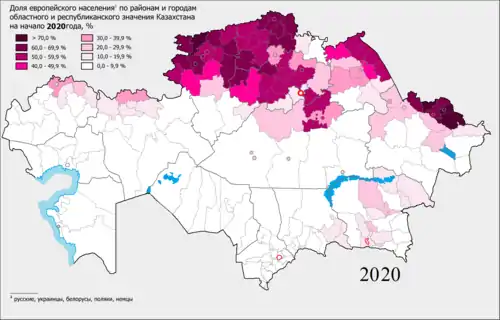
The share of the European population by districts and cities of regional and republican subordination Kazakhstan in 2016
> 70٪
60.0 – 69.9 %
50.0 - 59.9 %
40.0 - 49.9 %
30.0 - 39.9 %
20.0 - 29.9 %
10.0 - 19.9 %
0.0 - 9.9 %
|
| Regions of Kazakhstan Қазақстан облыстары (Kazakh) Области Казахстана (Russian) | |
|---|---|
| Also known as: Province Oblast | |
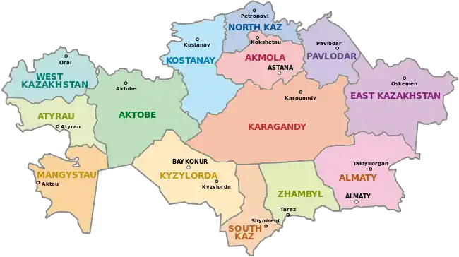
 A clickable map of Kazakhstan showing its 14 regions.v • d • e | |
| Category | Unitary state |
| Location | Republic of Kazakhstan |
| Number | 14 regions and 4 cities (Almaty, Nur-Sultan, Baikonur, Shymkent) |
| Populations | 36,175 (Baikonur) – 2,685,009 (Turkistan) |
| Areas | 680 km2 (263 sq mi) (Almaty) - 427,980 km2 (165,245 sq mi) (Karaganda) |
| Government | Region government, National government |
| Subdivisions | District |
Notes
- ^1 Almaty, Nur-Sultan and Shymkent cities have the status of State significance and do not relate to any region.
- ^2 The West Kazakhstan and Atyrau regions are both partly located in Eastern Europe as the Ural River run through Atyrau and Oral, their respective capital cities.
- ^3 Baikonur city has a special status because it is currently being leased to Russia with Baikonur Cosmodrome until the year 2050.
Demographic statistics
| Entity | Capital | Area (km²) | Population (2009 census)[1] | Population Density | ISO 3166-2 Code |
|---|---|---|---|---|---|
| Akmola Region | Kokshetau | 146,219 | 737,495 | 5.044 | KZ-AKM |
| Aktobe Region | Aktobe | 300,629 | 757,768 | 2.521 | KZ-AKT |
| Almaty | Almaty | 319 | 1,365,632 | 4281 | KZ-ALA |
| Almaty Region | Taldykorgan | 223,924 | 1,807,894 | 6.099 | KZ-ALM |
| Nur-Sultan | Nur-Sultan | 710 | 613,006 | 863.4 | KZ-AST |
| Atyrau Region | Atyrau | 118,631 | 510,377 | 4.302 | KZ-ATY |
| Baikonur | Baikonur | 57 | 36,175 | 644.6 | KZ-BAY* |
| East Kazakhstan Region | Oskemen | 283,226 | 1,396,593 | 4.931 | KZ-VOS |
| Jambyl Region | Taraz | 144,264 | 1,022,129 | 7.085 | KZ-ZHA |
| Karaganda Region | Karaganda | 427,982 | 1,341,700 | 3.135 | KZ-KAR |
| Kostanay Region | Kostanay | 196,001 | 885,570 | 4.518 | KZ-KUS |
| Kyzylorda Region | Kyzylorda | 226,019 | 678,794 | 3.003 | KZ-KZY |
| Mangystau Region | Aktau | 165,642 | 485,392 | 2.930 | KZ-MAN |
| North Kazakhstan Region | Petropavl | 97,993 | 596,535 | 6.088 | KZ-SEV |
| Pavlodar Region | Pavlodar | 124,800 | 742,475 | 5.948 | KZ-PAV |
| Shymkent | Shymkent | 1,170 | 603,499 | 515.81 | KZ- |
| Turkistan Region | Turkistan | 117,249 | 2,469,357 | 21.06 | KZ-TUR |
| West Kazakhstan Region | Oral | 151,339 | 598,880 | 3.957 | KZ-ZAP |
Former administrative boundaries

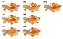
Over the last 60 years, both the distribution and names of regions of Kazakhstan have changed considerably. Major changes were several fusions and splits between Guryev and Mangystau, Karaganda and Dzhezkazgan, Almaty and Taldy-Kurgan, East Kazakhstan and Semipalatinsk and Kostanay, Turgay and Tselinograd, respectively. Changes in region names were often in line with the renaming of cities, such as in the case of Alma-Ata/Almaty. After the administrative reform in 1997, the last change happened since then took place in 1999, when parts of North Kazakhstan that originally belonged to Kokshetau region became part of Akmola. The 1990s merges were in order to dilute Russian population in the resulting region and to avoid having regions where Russians form a majority.[2]
References
- https://www.liportal.de/fileadmin/user_upload/oeffentlich/Kasachstan/40_gesellschaft/Kaz2009_Analytical_report.pdf
- Bologov, Pyotr (25 August 2016). "Три угрозы для Назарбаева: насколько стабилен Казахстан" (in Russian). carnegie.ru. Retrieved 29 August 2016.
