Kawkareik
Kawkareik (Eastern Pwo: ဍုံကောဝ်တြာ်; Burmese: ကော့ကရိတ်, [kɔ̰kəɹeɪʔ]; S'gaw Karen: ဒူဖျၢ်ယၢ်ဝ့ၢ်ဖိ) also spelled as Kawkarike, is a town in Karen State, Myanmar. It is the capital of Kawkaraik District and Kawkaraik Township.
Kawkareik
ဒူဖျၢ်ယၢ်ဝ့ၢ်ဖိ Kawkaraik | |
|---|---|
Town | |
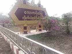 The sign reads: "A warm welcome from Kawkareik." | |
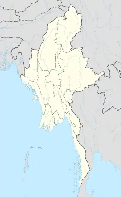 Kawkareik Location in Myanmar (Burma) | |
| Coordinates: 16°33′20″N 98°14′24″E | |
| Country | |
| Division | |
| District | Kawkareik District |
| Township | Kawkareik Township |
| Population (2014) | 98,000 |
| • Religions | Buddhism and Christianity |
| Time zone | UTC+6.30 (MMT) |
History
The Kawkareik Pass across the Tenasserim Hills is named after this town. The Pass was the access route from Thailand used by the Japanese Fifteenth Army, consisting of two infantry divisions under Lieutenant General Shōjirō Iida, when it invaded the southern Burmese province of Tenasserim (now Tanintharyi Region) in January 1942.
In January 2009, the forces of the Karen National Union and the Democratic Karen Buddhist Army clashed outside Kawkareik. The DKBA set up their military command post inside the town, and although DKBA soldiers burned down several civilian houses and detained dozens of citizens in villages across the border in Thailand, Kawkareik was left intact.[1]
Climate
| Climate data for Kawkareik (1981–2010) | |||||||||||||
|---|---|---|---|---|---|---|---|---|---|---|---|---|---|
| Month | Jan | Feb | Mar | Apr | May | Jun | Jul | Aug | Sep | Oct | Nov | Dec | Year |
| Average high °C (°F) | 33.3 (91.9) |
35.0 (95.0) |
36.7 (98.1) |
37.6 (99.7) |
34.4 (93.9) |
30.4 (86.7) |
29.4 (84.9) |
29.2 (84.6) |
31.1 (88.0) |
33.3 (91.9) |
33.6 (92.5) |
32.6 (90.7) |
33.1 (91.6) |
| Average low °C (°F) | 17.6 (63.7) |
18.2 (64.8) |
20.1 (68.2) |
22.5 (72.5) |
22.9 (73.2) |
22.6 (72.7) |
22.3 (72.1) |
22.2 (72.0) |
22.7 (72.9) |
22.7 (72.9) |
21.4 (70.5) |
19.2 (66.6) |
21.2 (70.2) |
| Average rainfall mm (inches) | 3.5 (0.14) |
9.6 (0.38) |
22.6 (0.89) |
73.8 (2.91) |
407.5 (16.04) |
833.2 (32.80) |
1,049.4 (41.31) |
1,105.7 (43.53) |
616.6 (24.28) |
234.2 (9.22) |
33.7 (1.33) |
7.1 (0.28) |
4,396.9 (173.11) |
| Source: Norwegian Meteorological Institute[2] | |||||||||||||
Transport
Kawkareik lies on the East-West Economic Corridor that links the South China Sea at Da Nang to Mawlamyine through Mae Sot and Myawaddy.[3]
Education
The town has two public high schools; BEHS (1) Kawkareik and BEHS (2) Kawkareik.
_-_panoramio_(1).jpg.webp)
There is no higher education institution in Kawkareik.
Healthcare
Kawkareik District Public Hospital serves the people of Kawkareik and its surrounding areas.
Notable people from Kawkareik
References
- "DKBA soldiers burn down huts, detain villagers and loot property in Thailand". Karen Human Rights Group. January 20, 2009. Archived from the original on July 23, 2011.
- "Myanmar Climate Report" (PDF). Norwegian Meteorological Institute. pp. 23–36. Archived from the original (PDF) on 8 October 2018. Retrieved 9 November 2018.
- "East-West Economic corridor still in planning stage: ADB official". The Myanmar Times. Retrieved 2017-10-25.
External links
| Wikimedia Commons has media related to Kawkareik. |
Capital: Hpa-an | ||
| Hpa-an District |  | |
| Hpapun District | ||
| Kawkareik District | ||
| Myawaddy District | ||
| Cities and towns | ||