Kelbra
Kelbra (German: [ˈkɛlbʁa] (![]() listen)) is a town the Mansfeld-Südharz district, in Saxony-Anhalt, Germany. It is situated north of the Kyffhäuser mountains, approx. 20 km west of Sangerhausen, and 20 km east of Nordhausen. Kelbra is part of the Verbandsgemeinde Goldene Aue.
listen)) is a town the Mansfeld-Südharz district, in Saxony-Anhalt, Germany. It is situated north of the Kyffhäuser mountains, approx. 20 km west of Sangerhausen, and 20 km east of Nordhausen. Kelbra is part of the Verbandsgemeinde Goldene Aue.
Kelbra | |
|---|---|
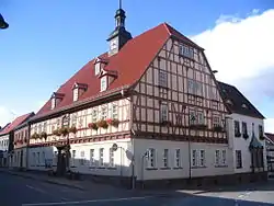 Town hall | |
 Coat of arms | |
Location of Kelbra within Mansfeld-Südharz district 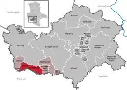 | |
 Kelbra  Kelbra | |
| Coordinates: 51°26′N 11°2′E | |
| Country | Germany |
| State | Saxony-Anhalt |
| District | Mansfeld-Südharz |
| Municipal assoc. | Goldene Aue |
| Government | |
| • Mayor | Lothar Bornkessel |
| Area | |
| • Total | 40.54 km2 (15.65 sq mi) |
| Elevation | 157 m (515 ft) |
| Population (2019-12-31)[1] | |
| • Total | 3,335 |
| • Density | 82/km2 (210/sq mi) |
| Time zone | UTC+01:00 (CET) |
| • Summer (DST) | UTC+02:00 (CEST) |
| Postal codes | 06537 |
| Dialling codes | 034651 |
| Vehicle registration | SGH |
| Website | www.kelbra.de |
Kelbra lies on the northern slopes of the Kyffhäuser mountains in der Goldene Aue. The B 85 federal road starts in the neighbouring village of Berga and runs through Kelbra over the Kyffhäuser to Passau.
Due to the proximity of the Kelbra Dam and the Kyffhäuser, the town is a type of tourist centre, but suffers from heavy day traffic, especially motorcycles, because the road climbing up to the Kyffhäuser starts here.
Nearby are the Barbarossa Cave and the Peasants' War Panorama in Bad Frankenhausen.
The villages of Sittendorf, Tilleda (Kyffhäuser) and Thürungen belong to the municipality of Kelbra.
Berga-Kelbra station, which is on the Halle–Hann. Münden railway is located nearby in Berga.
Town twinning
Kelbra is twinned with the English village of Frampton Cotterell and the German town of Bad Salzdetfurth.
References
- "Bevölkerung der Gemeinden – Stand: 31. Dezember 2019" (PDF). Statistisches Landesamt Sachsen-Anhalt (in German).
Towns and municipalities in the district of Mansfeld-Südharz | ||
|---|---|---|
Coat of arms | ||
| Authority control |
|---|
