Kentucky Route 128
Kentucky Route 128 (KY 128) is a 20.986-mile-long (33.774 km) state highway in Kentucky that runs from U.S. Route 68 (US 68) and KY 80 northwest of Gracey to KY 91 southeast of Princeton.
| ||||
|---|---|---|---|---|
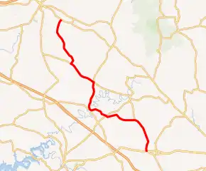
KY 128 highlighted in red | ||||
| Route information | ||||
| Maintained by KYTC | ||||
| Length | 20.986 mi[1] (33.774 km) | |||
| Major junctions | ||||
| South end | ||||
| North end | ||||
| Location | ||||
| Counties | Trigg, Caldwell | |||
| Highway system | ||||
| ||||

Major intersections
| County | Location | mi[1] | km | Destinations | Notes |
|---|---|---|---|---|---|
| Trigg | | 0.000 | 0.000 | Southern terminus | |
| | 3.875 | 6.236 | Southern terminus of KY 126 | ||
| | 4.464 | 7.184 | Northern terminus of KY 1507 | ||
| | 7.283 | 11.721 | |||
| | 9.078 | 14.610 | South end of KY 276 overlap | ||
| | 9.334 | 15.022 | North end of KY 276 overlap | ||
| Caldwell | | 12.342 | 19.863 | South end of KY 126 overlap; southern terminus of KY 672 | |
| | 13.577 | 21.850 | Eastern terminus of KY 514 | ||
| | 15.554 | 25.032 | North end of KY 126 overlap | ||
| Princeton | 19.534 | 31.437 | Northern terminus of KY 2068 | ||
| | 20.986 | 33.774 | Northern terminus | ||
| 1.000 mi = 1.609 km; 1.000 km = 0.621 mi | |||||
References
- "Official DMI Route Log". Kentucky Transportation Cabinet. Retrieved April 4, 2015.
This article is issued from Wikipedia. The text is licensed under Creative Commons - Attribution - Sharealike. Additional terms may apply for the media files.