Kentucky Route 58
Kentucky Route 58 (KY 58) is a 56.845-mile-long (91.483 km) state highway in Kentucky that runs from a dead end near Columbus to U.S. Route 68 (US 68) near Briensburg, Kentucky via Columbus, Clinton, Mayfield, and Benton.
| ||||
|---|---|---|---|---|
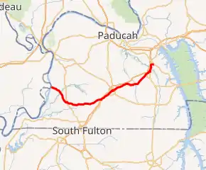
KY 58 highlighted in red | ||||
| Route information | ||||
| Maintained by KYTC | ||||
| Length | 56.845 mi[1] (91.483 km) | |||
| Major junctions | ||||
| West end | former ferry landing near Columbus | |||
| ||||
| East end | ||||
| Location | ||||
| Counties | Hickman, Graves, Marshall | |||
| Highway system | ||||
| ||||

Major intersections
| County | Location | mi | km | Destinations | Notes |
|---|---|---|---|---|---|
| Hickman | | 0.000 | 0.000 | Dead end near the Mississippi River | |
| Columbus | 0.445 | 0.716 | Southern terminus of KY 1757 | ||
| 0.530 | 0.853 | Southern terminus of KY 3058 | |||
| 0.573 | 0.922 | Western terminus of KY 80; west end of KY 123/GRR overlap | |||
| 0.761 | 1.225 | East end of KY 123 overlap | |||
| | 2.645 | 4.257 | Northern terminus of KY 1300 | ||
| | 4.375 | 7.041 | Southern terminus of KY 1772 | ||
| | 6.273 | 10.095 | Western terminus of KY 1540 | ||
| | 7.892 | 12.701 | Eastern terminus of KY 1475 | ||
| | 9.085 | 14.621 | West end of KY 1826 overlap | ||
| | 9.105 | 14.653 | East end of KY 1826 overlap | ||
| | 9.490 | 15.273 | West end of KY 123 overlap | ||
| Clinton | 10.146 | 16.328 | East end of KY 123 overlap; west end of US 51 concurrency; 51 also signed as GRR alternate route | ||
| 10.264 | 16.518 | East end of US 51 concurrency | |||
| 10.330 | 16.625 | Southern terminus of KY 1731 | |||
| | 13.473 | 21.683 | Eastern terminus of KY 780 | ||
| | 14.034 | 22.586 | Southern terminus of KY 2208 | ||
| | 15.978 | 25.714 | Southern terminus of KY 575 | ||
| | 16.460 | 26.490 | Western terminus of KY 944 | ||
| Fulgham | 17.590 | 28.308 | |||
| | 19.635 | 31.599 | Northern terminus of KY 3061 | ||
| Graves | | 21.045 | 33.869 | Northern terminus of KY 1283 | |
| Holifield | 22.218 | 35.756 | West end of KY 339 overlap | ||
| 22.245 | 35.800 | East end of KY 339 overlap | |||
| | 26.094 | 41.994 | West end of US 45 concurrency | ||
| | 26.750 | 43.050 | |||
| Mayfield | 30.362 | 48.863 | Southern terminus of US 45 Bypass | ||
| 32.897 | 52.943 | East end of US 45 concurrency; eastern terminus of KY 80 business route | |||
| 32.961 | 53.046 | Northern terminus of KY 121 business route | |||
| 33.811 | 54.414 | ||||
| | 34.586 | 55.661 | Western terminus of KY 1710 | ||
| | 35.523 | 57.169 | Southern terminus of KY 131 | ||
| | 36.459 | 58.675 | Southern terminus of KY 1821 | ||
| | 39.487 | 63.548 | Southern terminus of KY 301 | ||
| | 41.672 | 67.065 | Northern terminus of KY 564 | ||
| Marshall | | 43.993 | 70.800 | Southern terminus of KY 2603 | |
| | 44.404 | 71.461 | Western terminus of KY 402 | ||
| | 45.604 | 73.393 | Northern terminus of KY 1522 | ||
| Harvey | 47.057 | 75.731 | |||
| | 49.010 | 78.874 | |||
| Benton | 50.384 | 81.085 | Northern terminus of KY 1311 | ||
| 50.450 | 81.191 | ||||
| 52.294 | 84.159 | ||||
| 52.343 | 84.238 | West end of KY 408 overlap and US 641 North concurrency | |||
| 52.631 | 84.701 | East end of KY 408 overlap | |||
| 52.888 | 85.115 | Eastern terminus of KY 348; end of one-way split of 641/58 | |||
| 52.992 | 85.282 | Western terminus of KY 2609 | |||
| | 55.541 | 89.385 | East end of US 641 concurrency | ||
| | 56.629 | 91.136 | |||
| | 56.845 | 91.483 | Eastern terminus | ||
1.000 mi = 1.609 km; 1.000 km = 0.621 mi
| |||||
References
- Commonwealth of Kentucky. "Official DMI Route Log". Retrieved 24 June 2014.
This article is issued from Wikipedia. The text is licensed under Creative Commons - Attribution - Sharealike. Additional terms may apply for the media files.