Kentucky Route 83
Kentucky Route 83 (KY 83) is a 5.018-mile-long (8.076 km) state highway in Graves County, Kentucky that runs from Kentucky Route 303 just east of Cuba to Kentucky Route 94 northeast of Lynville.
| ||||
|---|---|---|---|---|
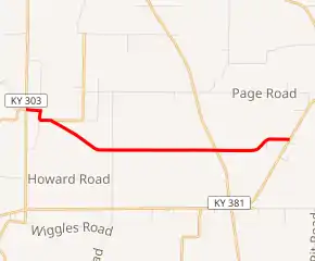
KY 83 highlighted in red | ||||
| Route information | ||||
| Maintained by KYTC | ||||
| Length | 5.018 mi[1] (8.076 km) | |||
| Major junctions | ||||
| West end | ||||
| East end | ||||
| Highway system | ||||
| ||||

Route description
KY 83 begins at an intersection with KY 303 east of Cuba in Graves County, where the road continues west as KY 2422. From this intersection, the route heads east as a two-lane undivided road, passing a few homes. KY 83 turns south and heads into farmland, curving east before it makes a turn to the southeast at an intersection with the southern terminus of KY 1390. The road continues through rural areas, curving to the east. Farther east, the route crosses KY 381. KY 83 heads northeast before it turns east again and reaches its eastern terminus at KY 94 northeast of Lynville.[1][2]
Major intersections
The entire route is in Graves County.
| Location | mi[1] | km | Destinations | Notes | |
|---|---|---|---|---|---|
| | 0.000 | 0.000 | Western terminus; continues as KY 2422 | ||
| | 0.596 | 0.959 | Southern terminus of KY 1390 | ||
| | 3.655 | 5.882 | |||
| | 5.018 | 8.076 | Eastern terminus | ||
| 1.000 mi = 1.609 km; 1.000 km = 0.621 mi | |||||
References
- "Official DMI Route Log". Kentucky Transportation Cabinet. Retrieved 28 June 2014.
- Google (June 29, 2014). "overview of Kentucky Route 83" (Map). Google Maps. Google. Retrieved June 29, 2014.