Kentucky Route 94
Kentucky Route 94 (KY 94) is a 79.816-mile-long (128.451 km) state highway in Kentucky that runs from Tennessee State Route 78 at the Tennessee state line to KY 80 southwest of the unincorporated community of Aurora via Hickman, Water Valley, and Murray.
| ||||
|---|---|---|---|---|
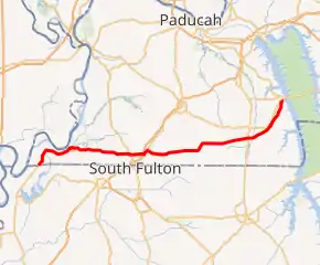
KY 94 highlighted in red | ||||
| Route information | ||||
| Maintained by KYTC | ||||
| Length | 79.816 mi[1] (128.451 km) | |||
| Major junctions | ||||
| West end | ||||
| East end | ||||
| Location | ||||
| Counties | Graves, Calloway, Marshall | |||
| Highway system | ||||
| ||||

Major intersections
| County | Location | mi | km | Destinations | Notes |
|---|---|---|---|---|---|
| Fulton | | 0.000 | 0.000 | Southern terminus; continuation beyond Tennessee state line | |
| Tyler | 0.587 | 0.945 | Eastern terminus of KY 2134 | ||
| | 1.436 | 2.311 | Western terminus of KY 1282 | ||
| | 4.083 | 6.571 | Southern terminus of KY 653; KY 971 just west of intersection | ||
| | 7.473 | 12.027 | Northern terminus of KY 311 | ||
| | 10.902 | 17.545 | Southern terminus of KY 1099 | ||
| Hickman | 11.768 | 18.939 | Eastern terminus of KY 1354 | ||
| 12.150 | 19.554 | Northern terminus of KY 309 | |||
| 13.218 | 21.272 | Northern terminus of KY 125 | |||
| 13.642 | 21.955 | Northern terminus of KY 1099 | |||
| | 17.098 | 27.517 | Northern terminus of KY 2140 | ||
| | 18.162 | 29.229 | |||
| | 19.701 | 31.706 | Northern terminus of KY 1127 | ||
| | 20.548 | 33.069 | Northern terminus of KY 1212 | ||
| | 22.121 | 35.600 | |||
| | 22.855 | 36.782 | Southern terminus of KY 1907 | ||
| | 23.448 | 37.736 | Western end of KY 781 overlap | ||
| | 24.471 | 39.382 | Eastern end of KY 781 overlap | ||
| | 26.105 | 42.012 | Western end of KY 1125 overlap | ||
| | 26.621 | 42.842 | Eastern end of KY 1125 overlap | ||
| | 27.084 | 43.587 | Northern terminus of KY 1706 | ||
| | 28.158 | 45.316 | Northern terminus of KY 1909 | ||
| | 29.115 | 46.856 | |||
| | 29.247 | 47.068 | Northern terminus of KY 94 Connector | ||
| Hickman | Enon | 31.223 | 50.249 | ||
| | 32.280 | 51.950 | Southern terminus of KY 1698 | ||
| | 33.458 | 53.845 | Western end of US 45 concurrency | ||
| Graves | Water Valley | 34.966 | 56.272 | Eastern end of US 45 concurrency; eastern terminus of KY 1529 | |
| | 35.466 | 57.077 | Northern terminus of KY 943 | ||
| Pilot Oak | 39.801 | 64.054 | Western end of KY 129 overlap | ||
| 40.067 | 64.482 | Eastern end of KY 129 overlap | |||
| | 42.446 | 68.310 | Western end of KY 385 overlap | ||
| | 42.941 | 69.107 | Eastern end of KY 385 overlap | ||
| | 44.951 | 72.342 | |||
| | 48.001 | 77.250 | Northern terminus of KY 1382 | ||
| Lynnville | 48.558 | 78.147 | |||
| | 48.707 | 78.386 | Western terminus of KY 1800 | ||
| | 50.234 | 80.844 | Eastern terminus of KY 83 | ||
| Tri City | 51.646 | 83.116 | |||
| | 52.121 | 83.881 | Southern terminus of KY 564 | ||
| | 53.616 | 86.287 | Southern terminus of KY 1814 | ||
| Calloway | Lynn Grove | 57.363 | 92.317 | ||
| | 59.224 | 95.312 | Southern terminus of KY 299 | ||
| | 60.249 | 96.961 | Western end of KY 783 overlap | ||
| | 60.743 | 97.756 | Eastern end of KY 783 overlap | ||
| Murray | 62.305 | 100.270 | Southern terminus of KY 1660 | ||
| 63.856 | 102.766 | Northern terminus of KY 822; university to the north on 16th | |||
| 64.376 | 103.603 | ||||
| 65.102 | 104.772 | ||||
| 65.494 | 105.402 | Southern terminus of KY 2594 | |||
| | 67.027 | 107.870 | Southern terminus of KY 1483 | ||
| | 67.698 | 108.949 | Western terminus of KY 280 | ||
| | 70.539 | 113.522 | Western terminus of KY 732 | ||
| | 71.974 | 115.831 | Southern end of KY-94/KY-80 connector | ||
| | 73.607 | 118.459 | Eastern terminus of KY 463 | ||
| | 74.165 | 119.357 | Eastern terminus of KY 1551 | ||
| | 75.480 | 121.473 | |||
| | 77.416 | 124.589 | Western terminus of KY 497 | ||
| Marshall | | 79.816 | 128.451 | Eastern terminus | |
1.000 mi = 1.609 km; 1.000 km = 0.621 mi
| |||||
Special routes
Kentucky Route 94 Spur (Calloway County)
| |
|---|---|
| Location | Calloway County |
| Length | 0.385 mi[1] (0.620 km) |
Kentucky Route 94 Spur (known as KY 94C for identification purposes) is a 0.385-mile spur route of Kentucky Route 94 in rural Calloway County northeast of Murray that connects KY 94 to Kentucky Route 80.
Major intersections
The entire route is in Calloway County.
| Location | mi[1] | km | Destinations | Notes | |
|---|---|---|---|---|---|
| | 0.000 | 0.000 | Southern terminus | ||
| | 0.385 | 0.620 | Northern terminus | ||
| 1.000 mi = 1.609 km; 1.000 km = 0.621 mi | |||||
Kentucky Route 94 Spur (Fulton County)
| |
|---|---|
| Location | Fulton County |
| Length | 0.312 mi[1] (0.502 km) |
Kentucky Route 94 Spur (known as KY 94C for identification purposes) is a 0.312-mile spur route of Kentucky Route 94 in rural Fulton County halfway between Crutchfield and Fulton that connects KY 94 to U.S. Route 51.
Major intersections
The entire route is in Fulton County.
| Location | mi[1] | km | Destinations | Notes | |
|---|---|---|---|---|---|
| | 0.000 | 0.000 | Southern terminus | ||
| | 0.312 | 0.502 | Northern terminus | ||
| 1.000 mi = 1.609 km; 1.000 km = 0.621 mi | |||||
References
- Commonwealth of Kentucky. "Official DMI Route Log". Retrieved 29 June 2014.