Kilworth
Kilworth (Irish: Cill Uird) is a village in north County Cork, located about 2 kilometres north of Fermoy near the river Funcheon. The M8 Cork–Dublin motorway passes nearby. Kilworth has an army camp, located on the R639 regional road between Mitchelstown and Fermoy. Kilworth is part of the Cork East Dáil constituency.
Kilworth
Cill Uird | |
|---|---|
Village | |
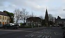 Kilworth village | |
 Kilworth Location in Ireland | |
| Coordinates: 52°10′35″N 8°14′39″W | |
| Country | Ireland |
| Province | Munster |
| County | Cork |
| Elevation | 72 m (236 ft) |
| Population (2016)[1] | |
| • Total | 1,055 |
| Time zone | UTC+0 (WET) |
| • Summer (DST) | UTC-1 (IST (WEST)) |
| Irish Grid Reference | R833027 |
History
The name Kilworth comes from the Irish language term "Cill Úird", literally meaning "church of the order". In the seventeenth and eighteenth centuries, Kilworth was a notable settlement on the old Dublin to Cork road, prior to the construction of the T6/old N8/R639 road from Fermoy to Cashel and from Cashel to Urlingford between 1739 and the mid-nineteenth century. Numerous accounts and maps dating from the 1680s tell of armies and travellers journeying from Fermoy to Clogheen and onwards to Dublin via Kilworth and Kilworth Mountain.[2]
Notable residents
One of Kilworth's most notable residents was David Richard Pigot, who became Chief Baron of the Irish Exchequer and one of the foremost Irish judges of his day. He was born in Kilworth about 1796, son of John Pigot, a doctor, and his wife Margaret Nagle. David Pigot's eldest son, John Edward Pigot, was also born in Kilworth and was one of the founders of the National Gallery of Ireland.
Amenities and attractions
Kilworth Arts centre is a theatre venue in the centre of the village. It was previously used as a church.
Kilworth (Glenseskin) forest is located about 1 km from the village centre.
Economy
Teagasc has an agricultural research facility based at Moorepark, just outside Kilworth. The village is within commuting distance of many centres of employment, including Cork city.
References
- "Census 2016 - Small Area Population Statistics (SAPMAP Area) - Settlements - Kilworth". Census 2016. Central Statistics Office.
- See, for example, David Broderick, The First Toll Roads: Ireland's Turnpike Roads, 1729–1858 (Cork, 2002); J. H. Andrews, Shapes of Ireland: Maps and Their Makers, 1564–1839 (Dublin, 1997); Taylor and Skinner's Maps of the Roads of Ireland (Dublin, 1778); and Herman Moll's New Map of Ireland (1714).