Urlingford
Urlingford (Irish: Áth na nUrlainn, meaning "Ford of the slaughter"[2]) is a town, as well as a civil parish within the barony of Galmoy.[3] It is located in the north west of County Kilkenny, along the boundary with County Tipperary, in Leinster, Ireland.
Urlingford
Irish: Áth na nUrlainn | |
|---|---|
Town | |
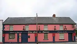 The Mason's Apron, Urlingford | |
 Urlingford Location in Ireland | |
| Coordinates: 52°43′13″N 7°34′57″W | |
| Country | Ireland |
| Province | Leinster |
| County | County Kilkenny |
| Elevation | 120 m (390 ft) |
| Population (2011)[1] | |
| • Urban | 973 |
| Time zone | UTC+0 (WET) |
| • Summer (DST) | UTC-1 (IST (WEST)) |
| Irish Grid Reference | S282633 |
Access
The town lies on the R639. The M8 motorway runs just west of the town, from which both Urlingford and nearby Johnstown are accessed via junction four. Urlingford is a bus hub, with major operator JJ Kavanagh and Sons based there.[4] Situated 125 km (78 mi) from Dublin and 129 km (80 mi) from Cork, Urlingford has long been a resting point for travellers halfway between the Republic of Ireland's two largest cities. As a result, until September 2013 the Bus Éireann Dublin to Cork bus service called here. It is now replaced by route 828 which connects with express buses at Portlaoise and Cashel.[5]
Toponymy
The Irish name Áth na nUrlainn means "ford of the slaughter" and has been anglicised as Aghnenurlin, Aghnenoorlin, Awnanoorlin and similar.[2]
History
| Year | Pop. | ±% |
|---|---|---|
| 1831 | 1,366 | — |
| 1841 | 1,742 | +27.5% |
| 1851 | 1,168 | −33.0% |
| 1936 | 492 | −57.9% |
| 1946 | 586 | +19.1% |
| 2011 | 973 | +66.0% |
| [6][7][8][9][10][1] | ||
In 1526, Piers Butler, 8th Earl of Ormond, gave possession of the lands of Urlingford to John Tobin and Nicolas Mothing (chaplins).[11] The earlier settlement was focused around the castle, church and graveyard.[12]
The town had an organised planned growth with traditional plot patterns.[12] It was built over a cut-over bog, an extension to the Templetuohy Bog,[12] much of which has been reclaimed.[13] Urlingford is a linear town around the focused primary axis, the Main Street.[12] In 1837 it was the centre of manufacture of coarse stuffs, flannels, and worsteds, and carries on an extensive retail trade with the surrounding districts.[14]
The town was recorded on Griffith's Valuation in 1864.[15] Urlingford has taken part in the Tidy Towns Competition.[16]
Geography
Rivers
A minor tributary of the River Nore, the River Goul, enters the town from the southeast.[12] It sources 6 kilometers away from the town in the Slieveardagh hills. The river passes under the Main Street and towards the bridge at Urlingford Castle (and mill).[12]
Buildings
There is a library in Urlingford[17] which is based in the old courthouse.[18] Urlingford Castle and mill are located in Urlingford.[12]
Sport
Emeralds GAA is a junior Gaelic Athletic Association club, founded in 1972.
References
- (CSO, Census 2011 – Population Classified by Area)
- (Fiontar 2008, Áth na nUrlainn/Urlingford)
- Down Survey Project. "Map of Urlingford Parish in the barony of Galmoy". downsurvey.tcd.ie. The Down Survey Project.
- JJ Kavanagh Bus Company
- http://buseireann.ie/news.php?id=1361&month=Sep
- (OHPR, p. 8, Comparative abstract, Ireland, 1831) and (OHPR, p. 40, Abstract, Ireland, 1831)
- (OHPR, p. 56, Report, Ireland, 1841)
- (OHPR, p. 93, County of Kilkenny, 1851)
- (CSO, 1936 Population Data)
- (CSO, 1946 Population Data)
- (Carrigan 1905, p. 23, Existing Civil Divisions or Baronies)
- (KCC)
- (Tighe 1802, p. 4, Bog, Mountain)
- Lewis 1837, URLINGFORD Parish
- (Griffith 1864, Urlingford Search)
- "Tidy Towns Competition 2015 Adjudication Report" (PDF).
- KCC, Kilkenny County Council. "Kilkenny County Library Service". kilkenny.ie.
- Buildings of Ireland. "Urlingford Public Library (Urlingford Courthouse), Urlingford, County Kilkenny". buildingsofireland.ie.
Sources
- Fiontar (2008). "Placenames Database of Ireland". logainm.ie. Department of Community, Rural and Gaeltacht Affairs of the Government of Ireland.CS1 maint: ref=harv (link)
- Griffith (1864). "Griffith's Valuation". www.askaboutireland.ie.CS1 maint: ref=harv (link)
- Carrigan, William (1905). The History and Antiquities of the Diocese of Ossory. Sealy, Bryers & Walker. ISBN 9785879206463.CS1 maint: ref=harv (link)
- Tighe, William (1802). Statistical observations relative to the county of Kilkenny: made in the years 1800 & 1801. Printed by Graisberry and Campbell.CS1 maint: ref=harv (link)
- CSO, Central Statistics Office. "CSO Website". cso.ie. Government of Ireland.CS1 maint: ref=harv (link)
- OHPR. "Histpop — The Online Historical Population Reports Project". histpop.org. University of Essex.CS1 maint: ref=harv (link)
- KCC. "Urban Design Study for Urlingford" (PDF). kilkennycoco.ie. Kilkenny County Council.CS1 maint: ref=harv (link)
- Lewis, Samuel (1837). A Topographical Dictionary of Ireland.CS1 maint: ref=harv (link)
External links
- Buildings of Ireland. "Urlingford Buildings (Urlingford Courthouse), Urlingford, County Kilkenny". buildingsofireland.ie.
- "JJ Kavanagh & Sons". jjkavanagh.ie.
Places in County Kilkenny | ||
|---|---|---|
| Towns | 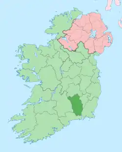 | |
| Villages |
| |
| Townlands | ||
| ||