King Sound
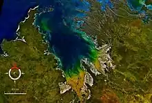
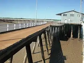
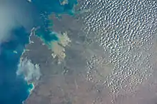
King Sound is a large gulf in northern Western Australia. It expands from the mouth of the Fitzroy River, one of Australia's largest watercourses, and opens to the Indian Ocean. It is about 120 kilometres (75 mi) long, and averages about 50 kilometres (31 mi) in width. The port town of Derby lies near the mouth of the Fitzroy River on the eastern shore of King Sound. King Sound has the highest tides in Australia, and amongst the highest in the world, reaching a maximum tidal range of 11.8 metres (39 ft) at Derby.[1] The tidal range and water dynamic were researched in 1997–1998.[2]
Other rivers that discharge into the sound include the Lennard River, Meda River, Robinson River and May River.
King Sound is bordered by the island clusters of the Buccaneer Archipelago to the East and Cape Leveque to the West.[3]
The traditional owners and original inhabitants of the area are Indigenous Australians, namely the Nimanburu, Njulnjul, and Warwa peoples.[4]
The first European to explore the sound was William Dampier who visited the region aboard Cygnet in 1688.
Noted surveyor Phillip Parker King surveyed the coastline in 1821 and named the area Cygnet Bay.[5] The area was later visited by John Stokes and John Wickham aboard HMS Beagle in 1838. The sound was later named after King.[6]
In the 1880s it was one of the sites in the Kimberleys of a short-lived gold rush.[7][8]
References
- Derby tides at derbytourism.com.au Archived 18 February 2007 at the Wayback Machine. Retrieved 7 January 2007
- Water and fine sediment dynamics in King Sound, Western Australia, Australian Ocean Data Network, 1998, retrieved 19 December 2013
- Australian Hydrographic Service; Australia. Army. Defence Topographic Agency (2003), Buccaneer Archipelago and King Sound, Australia – north west coast, Western Australia (New ed., 10 January 2003 ed.), Australian Hydrographic Service, retrieved 19 December 2013
- "Ausanthrop – AusAnthrop Australian Aboriginal tribal database". 2011. Retrieved 1 November 2011.
- King, Phillip Parker (1827). Narrative of a Survey of the Intertropical and Western Coasts of Australia. London: John Murray. http://gutenberg.net.au/ebooks/e00028.html#chapter02
- Murray, Ian; Hercock, Marion; Murray, Ian; Hercock, Marion (2008), Where on the coast is that?, Hesperian Press, ISBN 978-0-85905-452-2 page 160
- "KING SOUND AND CAMBRIDGE GULF KIMBERLEY, W.A." The Sydney Morning Herald. National Library of Australia. 6 September 1886. p. 9. Retrieved 19 December 2013.
- "THE KIMBERLEY RUSH". Globe. Sydney: National Library of Australia. 20 May 1886. p. 5 Edition: FIRST EDITION and EVENING. Retrieved 19 December 2013.
