Klahoose
The ƛoʔos Klahoose are one of the three groups comprising the 'ʔayʔaǰuθəm Tla'Amin or Mainland Comox. The other two divisions of this once-populous group are the χʷɛmaɬku Homalco and Sliammon (which is a corruption of "Tla A'min"). The Klahoose, Homalco and Sliammon are, according to oral tradition, the descendants of the survivors of the Great Flood.[1] The three groups were split by colonialism into different band councils but united historically as the Tla A'min, known as the Mainland Comox, and K’ómoks, the larger grouping of the Comox people, also known as the Island Comox and before the merger with the Laich-kwil-tach culture (which were known as the Sahtloot). Historically both groups are a subgroup of the Coast Salish though the K’ómoks name is from, and their language today, is the Lik'wala (Southern Kwakiutl) dialect of Kwak'wala. The ancestral tongue is the Comox language, though the Sahtloot/Island dialect is extinct.
The Klahoose are governed by the Klahoose First Nation and their main community is also called Klahoose, which is located at the head of Toba Inlet. Before the Laich-kwil-tach migration to the Campbell River area, Klahoose traditional territory extended from there to Cortes Island though the latter is now also claimed by the Kwiakah, one of the four main groupings of the Laich-kwil-tach.
Klahoose, the main Village for the Nation, is located at Squirrel Cove on Cortes Island has been growing over the years has a Health Centre, and 15,000 sq.ft, Multipurpose Building. The Multipurpose Building was built in 2010 and includes a health wing, fitness center, language lab, kitchen facilities and a three hundred person 'great room'.
The Klahoose First Nation has no year-round road access to a service centre and, as a result, experiences a higher cost of transportation. Serviced by BC Ferries, ferry connector service from Vancouver Island to Quadra Island and then Cortes Island.
Klahoose, at Squirrel Cove is home to approximately seventy-five full-time residents who live and work in the surrounding areas. The remaining Klahoose people, approximately three hundred, reside off reserve in BC coastal communities , lower mainland and in Washington State.
Klahoose First Nation
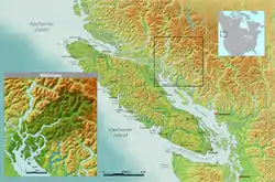
The Klahoose First Nation is a First Nations band government, the Indian Act-mandated government for the Klahoose group of Mainland Comox, whose traditional territories are located on Cortes Island at the northern end of the Strait of Georgia, and surrounding Toba Inlet, in southwestern British Columbia, Canada. Their traditionally community is at the head of that inlet, and is also called Klahoose, which is the site of Klahoose Indian Reserve No. 1.
The Klahoose First Nation are currently negotiating independently with Canada and British Columbia in the B.C. treaty process. The Klahoose First Nation Incremental Treaty Agreement - 2009. Other negotiations include the First Nations Clean Energy Business Fund (FNCEBF) Revenue Sharing Agreements (Jimmie Creek Hydro Project) - 2014. Forestry agreements including the Klahoose First Nation Forest Consultation & Revenue Sharing Agreement - 2017 and the Klahoose First Nation Interim Agreement on Forest Opportunities - 2018.
The Klahoose First Nation is a member government of the Naut'sa mawt Tribal Council (NmTC).
The Klahoose First Nation reserves include:
AHPOKUM 9 (24 Ha) Coast District at mouth of Forbes Creek, on Forbes Bay Homfray Channel in Desolation Sound
DEEP VALLEY 5 (25 Ha) Coast District on Quatam Bay, at mouth of the Quatam River East shore of Ramsay Arm
KLAHOOSE 1 (923 Ha) Coast District at mouth of Toba River at head of Toba Inlet
QUANIWSOM 2 (0.3 Ha) Coast District, near mouth of Tahumming River, at head of Toba Inlet
QUEQUA 6 (2 Ha) New Westminster District, on West Redonda Island, on East shore of Lewis Channel
SALMON BAY 3 (70 Ha) Coast District at head of Brem Bay, at mouth of Brem River North Side of Toba Inlet
SIAKIN 4 (3 Ha) New Westminster District, on West shore of East Redonda Island
SQUIRREL COVE 8 (16 Ha) Sayward District, East side of Cortes Island, at head of Squirrel Cove
TATPO-OOSE 10 (12 Ha) Sawyward District, on Southeast shore of Maurelle Island
TORK 7 (283 Ha) (Most populated village site, Band Office) Sawyward District, on East shore of Cortes Island Squirrel Cove
See also
References
- Hutchings and Williams 2020