Desolation Sound
Desolation Sound[1] (French: Baie Desolation) is a deep water sound at the northern end of the Salish Sea and of the Sunshine Coast in British Columbia, Canada.
| Desolation Sound | |
|---|---|
| French: Baie Desolation | |
 Desolation Sound | |
 Desolation Sound | |
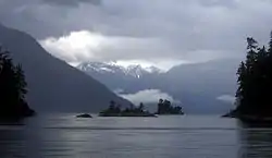
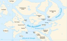 Extent of Desolation Sound | |
| Location | Discovery Islands, British Columbia |
| Coordinates | 50°07′20″N 124°45′30″W |
| Type | Sound |
| Part of | Salish Sea |
| Islands | Kinghorn Island, Martin Islands, Mink Island, Protection Island, Station Island |
| Settlements | Refuge Cove |
History
Desolation Sound was inhabited by tribes of the K'ómoks prior to the arrival of Europeans and falls within the traditional territories of the Klahoose First Nation, Tla'amin Nation, and Hamalco First Nations. In the summer of 1792, two expeditions led by Captains George Vancouver, Dionisio Alcalá Galiano and Cayetano Valdés y Flores arrived and cooperated in mapping the sound. Vancouver named it Desolation Sound, cryptically claiming that "there was not a single prospect that was pleasing to the eye". [2]
Geography
The sound is flanked by Cortes Island, East Redonda Island and West Redonda Island. Adjacent waterways include Lewis Channel (to the northwest), Waddington Channel (to the northeast), Homfray Channel (to the east), Okeover Inlet (to the southeast), and the Strait of Georgia (to the south).
Major provincial parks located within the sound include Desolation Sound Marine Provincial Park, Malaspina Provincial Park, Okeover Arm Provincial Park, and Roscoe Bay Provincial Park.
Demographics
Refuge Cove is the only community in Desolation Sound. It is located on West Redonda Island and administered within Strathcona Regional District. The community serves as a centrally located supply stop for boaters and local fishers travelling in or near Desolation Sound.
Industries
The major industries of Desolation Sound include shellfish farming, forestry, and ecotourism.
Transportation
Visitors travelling by car to Desolation Sound can take BC Ferries from Vancouver or Courtenay to Powell River, and drive the short distance northward to Lund. By boat or kayak from Lund, the Copeland Islands (Copeland Islands Marine Provincial Park) and Desolation Sound (which includes Desolation Sound Marine Provincial Park), and Malaspina Provincial Park.
Major anchorages include Gorge Harbour (on Cortes Island), Grace Harbour, Prideaux Haven (a cove on Homfray Channel), Refuge Cove, and Tenedos Bay.
Kayaking
Kayaking through the islands and fjords of Desolation Sound is a once in a lifetime experience. There are several kayaking businesses that operate in Desolation Sound for multi-day and day trips.
From Cortes Island, Cortes Kayaks offers kayak rentals and tours into desolation sound.
If you are travelling from the Sunshine Coast, Terracentric adventures offers tours into desolation sound.
References
- "Desolation Sound". Geographical Names Data Base. Natural Resources Canada. Retrieved 2020-06-16.
- Robson, Robson (2007). "Hakluyt edition of Vancouver's journals". W. Kaye Lamb, editor, Vol. 2, p 609. Archived from the original on 2007-06-22. Retrieved 2007-07-27.
External links
| Wikivoyage has a travel guide for Desolation Sound. |
![]() Media related to Desolation Sound at Wikimedia Commons
Media related to Desolation Sound at Wikimedia Commons