Koboko
Koboko is a town in Northern Region of Uganda. It is the main municipal, administrative, and commercial centre of Koboko District. Koboko is also the hometown of former dictator Idi Amin who ruled Uganda between 1971 and 1979.
Koboko | |
|---|---|
 Koboko Location in Uganda | |
| Coordinates: 03°24′36″N 30°57′36″E | |
| Country | |
| Region | Northern Region |
| Sub-region | West Nile sub-region |
| District | Koboko District |
| Elevation | 3,870 ft (1,180 m) |
| Population (2014 Census) | |
| • Total | 37,825[1] |
Location
Koboko is approximately 55 kilometres (34 mi), by road, north of Arua, the largest city in the West Nile sub-region.[2] This location is approximately 550 kilometres (342 mi), by road, northwest of Kampala, the capital and largest city of Uganda.[3] The coordinates of the town are 3°24'36.0"N, 30°57'36.0"E (Latitude:3.4100; Longitude:30.9600).[4]
Population
In 2002, the national census estimated the population of Koboko at 29,730. In 2010, the Uganda Bureau of Statistics (UBOS) estimated the population at 48,200. In 2011, UBOS estimated the mid-year population at 51,300.[5] In 2014, the national population census put Koboko's population at 37,825.[1]
Points of interest
The following points of interest lie within the town limits or close to the edges of town:
- headquarters of Koboko District administration
- offices of Koboko Town Council
- Koboko central market
- tripoint where the borders of Uganda, South Sudan, and the Democratic Republic of the Congo converge
- Vurra–Arua–Koboko–Oraba Road passes through town, in a south/north direction, intersecting with the Koboko–Yumbe–Moyo Road, in the center of Koboko.[6]
Notable people
- Idi Amin 3rd president of Uganda from 1971–1979. He is known as the Butcher of Uganda because of his influence
- James Baba Ugandan politician
- Evelyn Anite Ugandan politician and journalist
See also
References
- UBOS (29 November 2014). "The Population of The Regions of the Republic of Uganda And All Cities And Towns of More Than 15,000 Inhabitants". Citypopulation.de Quoting Uganda Bureau of Statistics (UBOS). Retrieved 28 February 2015.
- Globefeed.com (2 October 2019). "Distance Between Arua, Uganda And Koboko, Uganda". Globefeed.com. Retrieved 2 October 2019.
- Globefeed.com (2 October 2019). "Distance between Central Police Station, The Square 1, City Centre, Kampala, Uganda and Police Station, Koboko, Uganda". Globefeed.com. Retrieved 2 October 2019.
- Google (2 June 2014). "Location of Koboko At Google Maps" (Map). Google Maps. Google. Retrieved 2 June 2014.
- UBOS, . "Estimated Population of Koboko In 2002, 2010 And 2011" (PDF). Uganda Bureau of Statistics (UBOS). Archived from the original (PDF) on 7 July 2014. Retrieved 2 June 2014.CS1 maint: numeric names: authors list (link)
- Google (25 March 2016). "Map Showing Intersection of Vurra–Arua–Koboko–Oraba Road and Koboko–Yumbe–Moyo Road in Center of Koboko Town" (Map). Google Maps. Google. Retrieved 25 March 2016.
External links
Capital: Koboko | ||
| Counties and sub-counties | Koboko County | 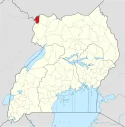 |
| Towns and villages | ||
| Economy | ||
| Transport | ||
| Notable landmarks |
| |
| Notable people | ||
Catgory:Karamoja
