Northern Region, Uganda
The Northern region is one of four regions in the country of Uganda.[1] As of Uganda's 2014 census, the region's population was 7,188,139.[2]
Northern | |
|---|---|
 Gulu is the Administrative Capital City of Northern region, Uganda, covering all parts of West Nile and Karamoja. | |
| Coordinates: 02°47′N 032°18′E | |
| Country | Uganda |
| Region | Northern |
| Regional capital | Gulu |
| Area | |
| • Total | 85,391.7 km2 (32,969.9 sq mi) |
| Elevation | 1,078 m (3,537 ft) |
| Population (2014 census)[2] | |
| • Total | 7,188,139 |
| • Estimate (2011) | 7,620,700 |
| • Density | 84/km2 (220/sq mi) |
| Time zone | UTC+3 (EAT) |
| HDI (2017) | 0.466[3] low · 4th |
Districts
As of 2010, the Northern Region had 30 districts:[2]

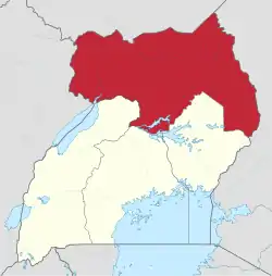
Northern region in yellow.
| District | Population (Census 1991) | Population (Census 2002) | Population (Census 2014) | Map | Chief town |
|---|---|---|---|---|---|
| Abim | 47,572 | 51,903 | 107,966 | 1 | Abim |
| Adjumani | 96,264 | 202,290 | 225,251 | 2 | Adjumani |
| Agago | 100,659 | 184,018 | 227,792 | 78 | Agago |
| Alebtong | 112,584 | 163,047 | 227,541 | 79 | Alebtong |
| Amolatar | 68,473 | 96,189 | 147,166 | 3 | Amolatar |
| Amudat | 11,336 | 63,572 | 105,767 | 80 | Amudat |
| Amuru | 88,692 | 135,723 | 186,696 | 39 | Amuru |
| Apac | 162,192 | 249,656 | 368,626 | 5 | Apac |
| Arua | 368,214 | 559,075 | 782,077 | 6 | Arua |
| Dokolo | 84,978 | 129,385 | 183,093 | 16 | Dokolo |
| Gulu | 211,788 | 298,527 | 436,345 | 17 | Gulu |
| Kaabong | 91,236 | 202,757 | 167,879 | 22 | Kaabong |
| Kitgum | 104,557 | 167,030 | 204,048 | 42 | Kitgum |
| Koboko | 62,337 | 129,148 | 206,495 | 43 | Koboko |
| Kole | 115,259 | 165,922 | 239,327 | 93 | Kole |
| Kotido | 57,198 | 122,442 | 181,050 | 44 | Kotido |
| Lamwo | 71,030 | 115,345 | 134,379 | 97 | Lamwo |
| Lira | 191,473 | 290,601 | 408,043 | 47 | Lira |
| Maracha | 107,596 | 145,705 | 186,134 | 50 | Maracha |
| Moroto | 59,149 | 77,243 | 103,432 | 57 | Moroto |
| Moyo | 79,381 | 194,778 | 139,012 | 58 | Moyo |
| Nakapiripirit | 66,248 | 90,922 | 156,690 | 62 | Nakapiripirit |
| Napak | 37,684 | 112,697 | 142,224 | 104 | Napak |
| Nebbi | 185,551 | 266,312 | 396,794 | 65 | Nebbi |
| Nwoya | 37,947 | 41,010 | 133,506 | 107 | Nwoya |
| Otuke | 43,457 | 62,018 | 104,254 | 108 | Otuke |
| Oyam | 177,053 | 268,415 | 383,644 | 67 | Oyam |
| Pader | 80,938 | 142,320 | 178,004 | 68 | Pader |
| Yumbe | 99,794 | 251,784 | 484,822 | 77 | Yumbe |
| Zombo | 131,315 | 169,048 | 240,082 | 112 | Zombo |
Demographics
| Census Year | Population |
|---|---|
| 1991 | 3,151,955 |
| 2002 | 5,148,882 |
| 2014 | 7,188,139 |
External links
References
- "Uganda: Administrative units". GeoHive. Archived from the original on 2013-05-11. Retrieved 18 June 2013.
- "Uganda: Administrative Division". citypopulation.de. Retrieved 8 November 2016.
- "Sub-national HDI - Area Database - Global Data Lab". hdi.globaldatalab.org. Retrieved 2018-09-13.
| Wikimedia Commons has media related to Northern Region, Uganda. |
This article is issued from Wikipedia. The text is licensed under Creative Commons - Attribution - Sharealike. Additional terms may apply for the media files.