Korea Bay
The Korea Bay, sometimes the West Korea Bay (Korean: 서조선만 or 서한만; Hanja: 西朝鮮灣 or 西韓灣; Korean pronunciation: [sʰʌdʑosʰʌn.man] or [sʰʌhan.man]), is a bight and the northern extension of the Yellow Sea,[1] between the southeastern coastline of China's Liaoning province and the western coastline of North Korea's North Pyongan, South Pyongan and South Hwanghae provinces.[2] It is separated from the Bohai Sea by the Liaodong Peninsula, with Dalian's Lüshunkou District marking its western end, and westernmost tip of North Korea's Ryongyon County as its eastern end.[3][4]
| Korea(n) Bay West Korea(n) Bay | |||||||
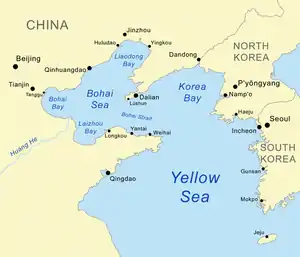 Map showing Korea Bay. | |||||||
| North Korean name | |||||||
|---|---|---|---|---|---|---|---|
| Chosŏn'gŭl | 서조선만 | ||||||
| Hancha | 西朝鮮灣 | ||||||
| |||||||
| South Korean name | |||||||
| Hangul | 서한만 | ||||||
| Hanja | 西韓灣 | ||||||
| |||||||
The Yalu (Amnok) River, which marks the western two-thirds of the China–North Korea border, empties into the Korea Bay between Dandong (China) and Sinŭiju (North Korea).[5][6] The Chongchon River and Taedong River also drains into the Korea Bay at Sinanju and Nampo, respectively.
References
- Merriam-Webster's Geographical Dictionary, Third Edition. Springfield, Mass.: Merriam-Webster. 1998. p. 605. ISBN 0-87779-546-0.
- Merriam-Webster's Geographical Dictionary, Third Edition. Springfield, Mass.: Merriam-Webster. 1998. p. 606. ISBN 0-87779-546-0.
- Merriam-Webster's Geographical Dictionary, Third Edition. Springfield, Mass.: Merriam-Webster. 1998. p. 647. ISBN 0-87779-546-0.
- Merriam-Webster's Geographical Dictionary, Third Edition. Springfield, Mass.: Merriam-Webster. 1998. p. 300. ISBN 0-87779-546-0.
- Merriam-Webster's Geographical Dictionary, Third Edition. Springfield, Mass.: Merriam-Webster. 1998. p. 1321. ISBN 0-87779-546-0.
- Merriam-Webster's Geographical Dictionary, Third Edition. Springfield, Mass.: Merriam-Webster. 1998. p. 1092. ISBN 0-87779-546-0.
External links
- . New International Encyclopedia. 1905.