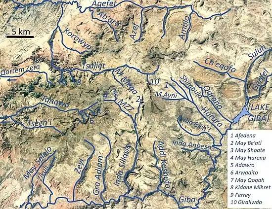
Korowya
Korowya is a river of the Nile basin. Rising in the mountains of Dogu’a Tembien in northern Ethiopia, it flows westward to empty finally in the Weri’i and Tekezé River.
| Korowya | |
|---|---|
 The Korowya River at Addi Kawa | |
 Korowya River in Kola Tembien | |
| Etymology | Named after the homonymous village |
| Location | |
| Country | Ethiopia |
| Region | Tigray Region |
| District (woreda) | Kola Tembien |
| Physical characteristics | |
| Source | Slopes of Tsili |
| • location | Haddinnet municipality |
| • elevation | 1,908 m (6,260 ft) |
| Mouth | Tsaliet River |
• location | 3.5 km north of Addeha |
• coordinates | 13.4657°N 39.1011°E |
• elevation | 1,643 m (5,390 ft) |
| Length | 12 km (7.5 mi) |
| Width | |
| • average | 50 m (160 ft) |
| Basin features | |
| River system | Permanent river (low baseflow) |
| Landmarks | Mt. Itay Sarah, Mika’el Samba and Maryam Hibeto rock churches |
| Bridges | N of Addeha, on the road to Hawzien |
| Topography | Pediment surrounded by steep sandstone mountains |
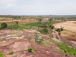
Characteristics
It is a meandering stream in a semi-confined alluvial plain, with an average slope gradient of 31 metres per kilometre.[1]
Flash floods and flood buffering
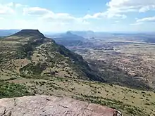
Runoff mostly happens in the form of high runoff discharge events that occur in a very short period (called flash floods). These are related to the steep topography, often little vegetation cover and intense convective rainfall. The peaks of such flash floods have often a 50 to 100 times larger discharge than the preceding baseflow.[1] The magnitude of floods in this river has not been decreased due to interventions in the catchment. Physical conservation structures such as stone bunds[2][3] and check dams are few and insufficient.[4][5] On many steep slopes, there are remnant forests; the dense vegetation contributes to enhanced infiltration, but cannot buffer the floods.[6]
Irrigated agriculture
Irrigation is strongly dependent on the river's baseflow. Such irrigated agriculture is important in meeting the demands for food security and poverty reduction.[1] Irrigated lands are established in the lower alluvial plains of Korowya River, and near springs at the headwaters.
Boulders and pebbles in the river bed
From upstream to downstream, the following lithological units occur in the catchment.[7]
Mostly the river bed is composed of sand, but one may find some pebbles, representing a mix of all lithologies crossed by the river.
From upper to lower Tembien
During its course, this river passes through two woredas.[8] On the various parts:
- The headwaters are in Dogu’a Tembien
- Most of the lower plain is in Kola Tembien
Trekking along the river
A trekking route has been established along this river.[9] The tracks are not marked on the ground but can be followed using downloaded .GPX files.[10]
- Trek 21, along and parallel to Korowya River
In the rainy season, flash floods may occur and it is advised not to follow the river bed. At times it may be impossible to cross the river in the rainy season.[11]
See also
- List of Ethiopian rivers
References
- Amanuel Zenebe, and colleagues (2019). The Giba, Tanqwa and Tsaliet rivers in the headwaters of the Tekezze basin. In: Geo-trekking in Ethiopia's Tropical Mountains - The Dogu'a Tembien District. SpringerNature. doi:10.1007/978-3-030-04955-3_14. ISBN 978-3-030-04954-6.
- Nyssen, Jan; Poesen, Jean; Gebremichael, Desta; Vancampenhout, Karen; d'Aes, Margo; Yihdego, Gebremedhin; Govers, Gerard; Leirs, Herwig; Moeyersons, Jan; Naudts, Jozef; Haregeweyn, Nigussie; Haile, Mitiku; Deckers, Jozef (2007). "Interdisciplinary on-site evaluation of stone bunds to control soil erosion on cropland in Northern Ethiopia". Soil and Tillage Research. 94 (1): 151–163. doi:10.1016/j.still.2006.07.011. hdl:1854/LU-378900.
- Gebeyehu Taye and colleagues (2015). "Evolution of the effectiveness of stone bunds and trenches in reducing runoff and soil loss in the semi-arid Ethiopian highlands". Zeitschrift für Geomorphologie. 59 (4): 477–493. doi:10.1127/zfg/2015/0166.
- Nyssen, J.; Veyret-Picot, M.; Poesen, J.; Moeyersons, J.; Haile, Mitiku; Deckers, J.; Govers, G. (2004). "The effectiveness of loose rock check dams for gully control in Tigray, Northern Ethiopia". Soil Use and Management. 20: 55–64. doi:10.1111/j.1475-2743.2004.tb00337.x.
- Etefa Guyassa and colleagues (2017). "Effects of check dams on runoff characteristics along gully reaches, the case of Northern Ethiopia". Journal of Hydrology. 545 (1): 299–309. doi:10.1016/j.jhydrol.2016.12.019. hdl:1854/LU-8518957.
- Descheemaeker, K. and colleagues (2006). "Runoff on slopes with restoring vegetation: A case study from the Tigray highlands, Ethiopia". Journal of Hydrology. 331 (1–2): 219–241. doi:10.1016/j.still.2006.07.011.
- Sembroni, A.; Molin, P.; Dramis, F. (2019). Regional geology of the Dogu'a Tembien massif. In: Geo-trekking in Ethiopia's Tropical Mountains — The Dogu'a Tembien District. SpringerNature. ISBN 978-3-030-04954-6.
- Jacob, M. and colleagues (2019). Geo-trekking map of Dogu'a Tembien (1:50,000). In: Geo-trekking in Ethiopia's Tropical Mountains - The Dogu'a Tembien District. SpringerNature. ISBN 978-3-030-04954-6.
- Description of trekking routes in Dogu'a Tembien. In: Geo-trekking in Ethiopia's Tropical Mountains - The Dogu'a Tembien District. SpringerNature. 2019. ISBN 978-3-030-04954-6.
- https://www.openstreetmap.org/traces/tag/nyssen-jacob-frankl
- Nyssen, Jan (2019). "Logistics for the Trekker in a Rural Mountain District of Northern Ethiopia". Geo-trekking in Ethiopia's Tropical Mountains. GeoGuide. Springer-Nature. pp. 537–556. doi:10.1007/978-3-030-04955-3_37. ISBN 978-3-030-04954-6.