Kunisaki
Kunisaki (国東市, Kunisaki-shi) is a city located in Ōita Prefecture, Kyushu, Japan.
Kunisaki
国東市 | |||||||||||||
|---|---|---|---|---|---|---|---|---|---|---|---|---|---|
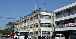 Kunisaki city hall | |||||||||||||
 Flag | |||||||||||||
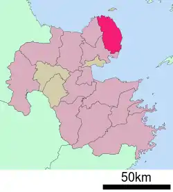 Location of Kunisaki in Ōita Prefecture | |||||||||||||
 Kunisaki Location in Japan | |||||||||||||
| Coordinates: 33°33′55″N 131°43′52″E | |||||||||||||
| Country | Japan | ||||||||||||
| Region | Kyushu | ||||||||||||
| Prefecture | Ōita Prefecture | ||||||||||||
| Government | |||||||||||||
| • Mayor | Akifumi Mikawa (since March 2011) | ||||||||||||
| Area | |||||||||||||
| • Total | 317.84 km2 (122.72 sq mi) | ||||||||||||
| Population (March 31, 2017) | |||||||||||||
| • Total | 29,098 | ||||||||||||
| • Density | 92/km2 (240/sq mi) | ||||||||||||
| Time zone | UTC+09:00 (JST) | ||||||||||||
| City hall address | 873-0501 | ||||||||||||
| Website | http://www.city.kunisaki.oita.jp | ||||||||||||
| |||||||||||||
The modern city of Kunisaki was founded on March 31, 2006, from the merger of the former town of Kunisaki, absorbing the towns of Aki, Kunimi and Musashi (all from Higashikunisaki District).
As of March 31, 2017, the city has an estimated population of 29,098, with 13,223 households and a population density of 92/km2 (240/sq mi).[1] The total area is 317.84 km2 (122.72 sq mi).
Oita Airport is located in Kunisaki.
Access
- 1 hr 30 mins by air from Tokyo Haneda airport to Oita airport
- 55 mins by air from Osaka Itami airport/Kansai International Airport to Oita airport
- 1 hr 10 mins from Nagoya Chubu International Airport to Oita airport
Demographics
Population data for Kunisaki, as of 30 September 2011
| Town | Male | Female | Total | No. of households |
|---|---|---|---|---|
| Kunisaki-machi | 5784 | 6435 | 12219 | 5153 |
| Kunimi-machi | 2287 | 2608 | 4895 | 2181 |
| Musashi-machi | 2716 | 2824 | 5540 | 2279 |
| Aki-machi | 4534 | 4869 | 9403 | 3826 |
| Totals | ||||
| Kunisaki-City | 15321 | 16736 | 32057 | 13439 |
Population distribution (2005 Census)
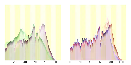
| National Population distribution by age(2005) | Age distribution by gender, for Kunisaki(2005) |
|---|---|
| ■ Purple - Kunisaki | ■ Blue - Men |
| ■ Green - Japan | ■ Red - Women |
Geography
Located in northern Kyushu and the north east of Oita prefecture.
Mountains
- Mt. Futago (Futago-san) at 720m and the tallest
- Mt. Monju (Monju-san)
- Mt. Odomure
- Mt. Otake
- Mt. Takeshi Washinosu
- Mt. Fudo (or Hudo)
Geology
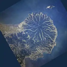
The Kunisaki Peninsula is formed from large conical volcanoes, including the 720-metre-tall (2,360 ft) Mt. Futago. Twenty-eight ravines radiate outward from the peninsula’s center.
Nuclear-free zone
On June 25, 2008, the City of Kunisaki declared itself a 'Nuclear-free Peace City" in wishing the abolition of nuclear weapons and world permanent peace.[2]
Industry
The following major companies are based in Kunisaki.
- Canon Inc
- Sony Semiconductor Corporation
Education
Kunisaki-machi
- Tomiku Elementary School
- Kunisaki Elementary School
- Owara Elementary School
- Asahi Elementary School
Musashi-machi
- Musashi Nishi Elementary School
- Musashi Higashi Elementary School
Aki-machi
- Aki Chuo Elementary School
- Aki Elementary School
Kunimi-machi
- Taketazu Elementary School
- Imi Elementary School
- Kumage SElementary School
Junior high schools
- Kunisaki Junior High School
- Musashi Junior High School
- Aki Junior High School
- Kunimi Junior High School
Transportation
Attractions and festivals
- Gyonyu Dam and Lake Taro
Temples
- Futago-ji
- Monjusen-ji
- Senpuku-ji (also Sempuku-ji)
- Iwato-ji
- Ankoku-ji
- Joubutsu-ji
- Tomiku-ji
Notable people from Kunisaki
References
- "Official website of Kunisaki city" (in Japanese). Japan: Kunisaki City. Retrieved 20 April 2017.
- "Archived copy". Archived from the original on 2013-06-11. Retrieved 2013-05-24.CS1 maint: archived copy as title (link)
External links
| Wikimedia Commons has media related to Kunisaki, Oita. |
| Authority control |
|---|
