Kunturkunka
Kunturkunka (Quechua kuntur condor, kunka throat, gullet, neck, voice,[2] Hispanicized spelling Condorcunca) is a mountain in the Andes of Peru. It is located in the Ayacucho Region, Huamanga Province, Quinua District.[3] Kunturkunka lies southwest of the mountain Saraqucha Q'asa ("maize lake mountain pass"), Hispanicized Saracochajasa) at the plain named Pampa de Quinua or Pampa de Ayacucho. This is where the Battle of Ayacucho took place. Today it is a protected area known as Pampa de Ayacucho Historical Sanctuary.
| Kunturkunka | |
|---|---|
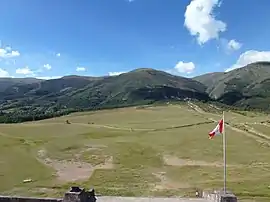 Kunturkunka as seen from the obelisk at Pampa de Quinua | |
| Highest point | |
| Coordinates | 13°00′28.3″S 74°06′3.5″W [1] |
| Geography | |
 Kunturkunka Peru | |
| Location | Peru, Ayacucho Region, Huamanga Province |
| Parent range | Andes |
References
- "Cerro Condorcunca". mapcarta. Retrieved April 12, 2014.
- Teofilo Laime Ajacopa, Diccionario Bilingüe Iskay simipi yuyayk'ancha, La Paz, 2007 (Quechua-Spanish dictionary)
- escale.minedu.gob.pe - UGEL map of the Huamanga Province (Ayacucho Region) showing the location of Kunturkunka (unnamed) southwest of the mountain Saraqucha Q'asa (Saracochajasa)
This article is issued from Wikipedia. The text is licensed under Creative Commons - Attribution - Sharealike. Additional terms may apply for the media files.
