Kwhlosothar Rural Municipality
Kwbholasothar (Nepali: क्व्होलासोथार) is a rural municipalty in the Lamjung District in Gandaki Pradesh of central Nepal. On 10 March 2017, The Federal Affairs and Local Development implemented the new local administrative structure consisting of 744 local units.[1] Kwbholasothar is a local municipal unit in Lamjung.[2] It is created by merging (1,2,5,6) wards of Balungpani, Maling, Uttarkanya, Bhujung, Pasagaun, Bhoje and Gilung.[3] The total population of Kwbholasothar is 10,032. And the total area is 175.37 km2. It is divided into 9 wards.[4] The administrative center of the rural municipality is located at former Maling V.D.C.. The rural municipality is surrounded by Besisahar Municipality; Marsyandi Rural Municipality in the east, Kaski District is in the west, Kaski District and Marsyandi Rural Municipality are located in the north and Madhya Nepal Municipality and Besisahar Municipality are situated in the south.
Kwbholasothar
क्व्होलासोथार | |
|---|---|
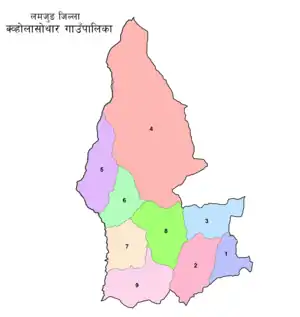 Wards of Kwbholasothar | |
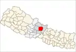
 Kwbholasothar Location in Nepal | |
| Coordinates (Maling): 28.23°N 84.29°E | |
| Country | |
| Province | Gandaki Pradesh |
| District | Lamjung District |
| Area | |
| • Total | 175.35 km2 (67.70 sq mi) |
| Population | |
| • Total | 10,032 |
| • Density | 57/km2 (150/sq mi) |
| Time zone | UTC+5:45 (Nepal Time) |
| Area code(s) | +977-52 |
| HQ | Office of Maling |
| Website | kwholasotharmun |
References
- "744 new local units come into effect". The Kathmandu Post. Retrieved 15 March 2017.
- "Which local units are you in?". Seto Pati. Archived from the original on 12 March 2017. Retrieved 16 March 2017.
- "Which local unit do you belong to?". MyRepublica. Retrieved 11 March 2017.
- "List of local bodies". MoFALD. Government of Nepal. Retrieved 1 June 2017.