La Macaza, Quebec
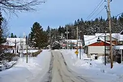
La Macaza is a municipality and village in the province of Quebec, Canada. The village is located in the Laurentian Mountains, in the Laurentian region, in Antoine-Labelle Regional County Municipality. Its population was 1053 in the Canada 2011 Census.
La Macaza | |
|---|---|
 | |
 Location within Antoine-Labelle RCM | |
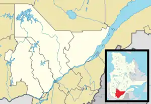 La Macaza Location in central Quebec | |
| Coordinates: 46°22′N 74°46′W[1] | |
| Country | |
| Province | |
| Region | Laurentides |
| RCM | Antoine-Labelle |
| Settled | 1866 |
| Constituted | January 1, 2006 |
| Government | |
| • Mayor | Christian Bélisle |
| • Federal riding | Laurentides—Labelle |
| • Prov. riding | Labelle |
| Area | |
| • Total | 175.50 km2 (67.76 sq mi) |
| • Land | 162.78 km2 (62.85 sq mi) |
| Population (2011)[3] | |
| • Total | 1,053 |
| • Density | 6.5/km2 (17/sq mi) |
| • Pop 2006-2011 | |
| • Dwellings | 1,020 |
| Time zone | UTC−5 (EST) |
| • Summer (DST) | UTC−4 (EDT) |
| Postal code(s) | J0T 1R0 |
| Area code(s) | 819 |
| Highways | No major routes |
It is home to the La Macaza – Mont Tremblant International Airport that serves the region. A medium security federal penitentiary is located next to the airport.
There is a covered bridge that runs over the Macaza River, built in 1904, and is an international tourist attraction. There are many lakes and beaches in the municipality.
According to the Geographic Names of the Province of Quebec (1921), "Macaza is the name of a native chief from the region", possibly the name of an old Amerindian who camped on the shores of Lake Macaza.[1]
History
Although indigenous peoples had lived in the area, the first European settlers arrived circa 1866. In 1904, La Macaza was established when the parish of Notre-Dame-du-Divin-Pasteur (Our Lady of Divine Shepherd) was founded. In 1930, the municipality was formed when its territory was detached from the municipality of Marchand (now part of Rivière-Rouge).[1]
It was first a farming community and later on its inhabitants worked mostly in logging, but today La Macaza receives a flood of vacationers each year.[1]
On December 18, 2002, La Macaza was merged into the new town of Rivière-Rouge when the Québec government forced certain province-wide mergers that were alleged to save citizens money. In 2004 the residents voted to separate from the city and on January 1, 2006, the municipality was reinstated.[1]
Demographics
Population trend:[4]
- Population in 2011: 1053 (2006 to 2011 population change: 7.4%)
- Population in 2006: 980
- Population in 2001: 1015
- Population in 1996: 1020
- Population in 1991: 900
Private dwellings occupied by usual residents: 481 (total dwellings: 1020)
Mother tongue:
- English as first language: 2%
- French as first language: 92%
- English and French as first language: 1%
- Other as first language: 6%
Education
Sainte Agathe Academy (of the Sir Wilfrid Laurier School Board) in Sainte-Agathe-des-Monts serves English-speaking students in this community for both elementary and secondary levels.[5]
See also
References
- "La Macaza (Municipalité)" (in French). Commission de toponymie du Québec. Retrieved 2009-08-12.
- Total area: Ministère des Affaires municipales, des Régions et de l'Occupation de territoire Archived 2012-05-01 at the Wayback Machine
- Statistics Canada 2011 Census - La Macaza census profile
- Statistics Canada: 1996, 2001, 2006, 2011 census
- "About Us." Saint Agathe Academy. Retrieved on September 4, 2017. See Elementary zone map and Secondary zone map - Note that all areas covered in the elementary map are also covered in the secondary one.
External links
 Media related to La Macaza at Wikimedia Commons
Adjacent Municipal Subdivisions | ||||||||||
|---|---|---|---|---|---|---|---|---|---|---|
| ||||||||||
| Cities/towns | |
|---|---|
| Municipalities | |
| Villages | |
| Unorganized territories | |
| |
| Authority control |
|
|---|