La Paz, Tarlac
La Paz, officially the Municipality of La Paz (Kapampangan: Balen ning La Paz; Pangasinan: Baley na La Paz; Tagalog: Bayan ng La Paz), is a 2nd class municipality in the province of Tarlac, Philippines. According to the 2015 census, it has a population of 64,017 people. [3]
La Paz | |
|---|---|
| Municipality of La Paz | |
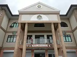 Municipal Hall | |
 Seal | |
 Map of Tarlac with La Paz highlighted | |
OpenStreetMap 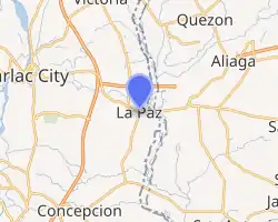
| |
.svg.png.webp) La Paz Location within the Philippines | |
| Coordinates: 15°26′35″N 120°43′44″E | |
| Country | |
| Region | Central Luzon (Region III) |
| Province | Tarlac |
| District | 3rd District |
| Founded | January 24, 1892 |
| Barangays | 21 (see Barangays) |
| Government | |
| • Type | Sangguniang Bayan |
| • Mayor | Venustiano D. Jordan |
| • Vice Mayor | Lorna R. Manalo |
| • Representative | Noel L. Villanueva |
| • Electorate | 39,529 voters (2019) |
| Area | |
| • Total | 114.33 km2 (44.14 sq mi) |
| Elevation | 21 m (69 ft) |
| Population | |
| • Total | 64,017 |
| • Density | 560/km2 (1,500/sq mi) |
| • Households | 13,885 |
| Economy | |
| • Income class | 2nd municipal income class |
| • Poverty incidence | 16.61% (2015)[4] |
| • Revenue | ₱135,734,407.76 (2016) |
| Time zone | UTC+8 (PST) |
| ZIP code | 2314 |
| PSGC | |
| IDD : area code | +63 (0)45 |
| Climate type | tropical monsoon climate |
| Native languages | Kapampangan Tagalog Ilocano |
History
The early history of La Paz is unclear. Legends state that there was an old pueblo called "Cama Juan" situated along the bank of the Chico River, bordering the province of Tarlac and Nueva Ecija. When the Chico River overflowed during a storm, a great flood swept the entire pueblo during the night. The flood is said to have devastated the area, claiming many lives.[5]
This forced the inhabitants of "Cama Juan" to evacuate. The old site (Cama Juan) is known as "Balen Melakwan" or "Abandoned Town".
The inhabitants chose a field of evergreen grass and shrubbery on which to rebuild, which they named "Matayumtayum".[5]
Towards the end of the nineteenth century, Francisco Macabulos and Captain Mariano Ignacio selected a more centrally located site for the future town to be known as La Paz. This existed only as a barrio of the town of Tarlac until 1892, when it was separated from the latter and rechristened in honor of its patron saint Nuestra Senora de La Paz y Buen Viaje. Its emergence as a new town gave its citizens a chance to run their own government with Martin Aquino as the first Governadorcillo.[5]
La Paz was made the first seat of the revolutionary government of the province of Tarlac during the Spanish regime with Gen. Francisco Makabulos as its first provincial governor.
Geography
La Paz lies in the southeast portion of the province of Tarlac, 130 kilometres (81 mi) from Metro Manila, 19 kilometres (12 mi) from the provincial capital (Tarlac City) and 77 kilometres (48 mi) from the regional center (San Fernando City aka San Fernando, Pampanga). It is bounded on the north by the town of Victoria, on the east by the Province of Nueva Ecija, on the south by the town of Concepcion and on the west by Tarlac City.
The municipality has a total land area of 11,433 hectares (28,250 acres) which represents 2.34% of the entire provincial area. La Paz is politically subdivided into 18 barangays, of which barangays San Isidro and San Roque are considered as urban areas and the rest of the barangays are considered rural areas.
Barangays
Climate
| Climate data for La Paz, Tarlac | |||||||||||||
|---|---|---|---|---|---|---|---|---|---|---|---|---|---|
| Month | Jan | Feb | Mar | Apr | May | Jun | Jul | Aug | Sep | Oct | Nov | Dec | Year |
| Average high °C (°F) | 28 (82) |
30 (86) |
31 (88) |
33 (91) |
33 (91) |
31 (88) |
30 (86) |
29 (84) |
29 (84) |
30 (86) |
30 (86) |
29 (84) |
30 (86) |
| Average low °C (°F) | 10 (50) |
20 (68) |
20 (68) |
22 (72) |
24 (75) |
24 (75) |
24 (75) |
24 (75) |
24 (75) |
23 (73) |
22 (72) |
21 (70) |
22 (71) |
| Average precipitation mm (inches) | 4 (0.2) |
4 (0.2) |
5 (0.2) |
11 (0.4) |
66 (2.6) |
99 (3.9) |
127 (5.0) |
113 (4.4) |
99 (3.9) |
84 (3.3) |
35 (1.4) |
14 (0.6) |
661 (26.1) |
| Average rainy days | 2.2 | 1.9 | 3.2 | 5.3 | 16.1 | 20.8 | 23.5 | 22.8 | 22.2 | 16.5 | 8.9 | 3.5 | 146.9 |
| Source: Meteoblue [6] | |||||||||||||
Demographics
| Year | Pop. | ±% p.a. |
|---|---|---|
| 1903 | 4,389 | — |
| 1918 | 8,991 | +4.90% |
| 1939 | 13,298 | +1.88% |
| 1948 | 18,395 | +3.67% |
| 1960 | 21,843 | +1.44% |
| 1970 | 27,150 | +2.20% |
| 1975 | 32,885 | +3.92% |
| 1980 | 35,330 | +1.44% |
| 1990 | 41,946 | +1.73% |
| 1995 | 45,207 | +1.41% |
| 2000 | 52,907 | +3.43% |
| 2007 | 61,324 | +2.06% |
| 2010 | 60,982 | −0.20% |
| 2015 | 64,017 | +0.93% |
| Source: Philippine Statistics Authority [3] [7] [8][9] | ||
In the 2015 census, the population of La Paz, Tarlac, was 64,017 people, [3] with a density of 560 inhabitants per square kilometre or 1,500 inhabitants per square mile.
Tourism
The feast of Nuestra De Seṅora De La Paz every January 23 to 24. Other tourism attractions in the town include Macabulos ancestral house, Nuestra Seṅora De La Paz Church, and Chico River Grill Station.
Transportation
The municipality has an approximate total road network of 78.863 kilometres (49.003 mi) which are classified into four (4) categories, namely: national, provincial, municipal and barangay roads.
The barangay road network has an approximate length of 49.264 kilometres (30.611 mi). The roads are paved with either concrete, asphalt, gravel or dirt. The gravel and dirt roads have a total length of 42.794 kilometres (26.591 mi).
La Paz is the northern terminus of the Subic–Clark–Tarlac Expressway (SCTEx) where it connects with Tarlac–Pangasinan–La Union Expressway (TPLEx) and Central Luzon Link Expressway (CLLEx).
Several buses from Metro Manila going Nueva Ecija passes through the town via Subic–Clark–Tarlac Expressway (SCTEx).
Points of interest
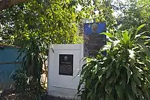
- (F-1790) Shrine of Our Lady of Peace and Good Voyage (Nuestra Señora de la Paz y Buen Viaje), La Paz 2314 Tarlac, Philippines (Titular: Our Lady of Peace and Good Voyage, Feast day, January 24; Former Parish Priest: Father Ramon Capuno under the Roman Catholic Diocese of Tarlac; Pilgrims seek healing; Vicariate of Immaculate Conception (Victoria, Tarlac) Vicar Forane: Father Vely Lapitan.LA PAZ: THE CORRIDOR OF UPCOMING MARKET GROWTH AND BOOM
Images
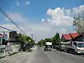 Highway
 Legislative building
 Public market
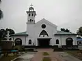 La Paz Church Shrine of Our Lady of Peace and Good Voyage
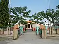 Park
Park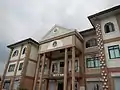 Town hall Facade
References
- Municipality of La Paz | (DILG)
- "Province: Tarlac". PSGC Interactive. Quezon City, Philippines: Philippine Statistics Authority. Retrieved 12 November 2016.
- Census of Population (2015). "Region III (Central Luzon)". Total Population by Province, City, Municipality and Barangay. PSA. Retrieved 20 June 2016.
- "PSA releases the 2015 Municipal and City Level Poverty Estimates". Quezon City, Philippines. Retrieved 1 January 2020.
- "Brief history of La Paz". Municipality of La Paz. 2012. Archived from the original on 2013-08-19. Retrieved 28 November 2012.
- "La Paz: Average Temperatures and Rainfall". Meteoblue. Retrieved 5 May 2020.
- Census of Population and Housing (2010). "Region III (Central Luzon)". Total Population by Province, City, Municipality and Barangay. NSO. Retrieved 29 June 2016.
- Censuses of Population (1903–2007). "Region III (Central Luzon)". Table 1. Population Enumerated in Various Censuses by Province/Highly Urbanized City: 1903 to 2007. NSO.
- "Province of Tarlac". Municipality Population Data. Local Water Utilities Administration Research Division. Retrieved 17 December 2016.
External links
| Wikimedia Commons has media related to La Paz, Tarlac. |
- La Paz Profile at PhilAtlas.com
- Philippine Standard Geographic Code
- New Website
- La Paz, Tarlac
- Official government website
- Philippine Census Information
Places adjacent to La Paz, Tarlac | |
|---|---|