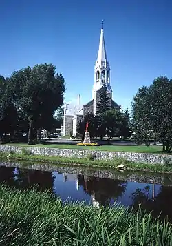
La Sarre
La Sarre is a town in northwestern Quebec, Canada, and is the most populous town and seat of the Abitibi-Ouest Regional County Municipality.[1][4] It is located at the intersection of Routes 111 and 393, on the La Sarre River, a tributary of Lake Abitibi.
La Sarre | |
|---|---|
 | |
| Motto(s): Oblivisci Nescius | |
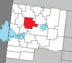 Location within Abitibi-Ouest RCM. | |
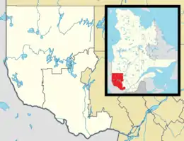 La Sarre Location in western Quebec. | |
| Coordinates: 48°48′N 79°12′W[1] | |
| Country | |
| Province | |
| Region | Abitibi-Témiscamingue |
| RCM | Abitibi-Ouest |
| Settled | 1912 |
| Constituted | 19 April 1980 |
| Government | |
| • Mayor | Yves Dubé |
| • Federal riding | Abitibi—Témiscamingue |
| • Prov. riding | Abitibi-Ouest |
| Area | |
| • Total | 151.70 km2 (58.57 sq mi) |
| • Land | 148.74 km2 (57.43 sq mi) |
| Population (2011)[3] | |
| • Total | 7,719 |
| • Density | 51.9/km2 (134/sq mi) |
| • Pop 2006-2011 | |
| • Dwellings | 3,617 |
| Time zone | UTC−5 (EST) |
| • Summer (DST) | UTC−4 (EDT) |
| Postal code(s) | J9Z |
| Area code(s) | 819 |
| Highways | |
| Website | www |
In addition to La Sarre itself, the town's territory also includes the community of Bienvenu, located along Route 111 west of the La Sarre River.
History
Before colonization, the area was home to the indigenous Algonquin who called the place Wabakin, from wàba and akin meaning "there is a mountain of hardwood", and called the La Sarre River Adikameg Sibi, which was also identified as Amikitik.[1]
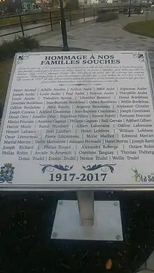
The first white settlers, six in number, settled as squatters on the land in the late 19th century and were discovered during the survey of the township in 1908. Real colonization began at the time when the National Transcontinental Railway running through the Abitibi region was completed. The first permanent pioneer family arrived in 1912, followed by more settlers and development drawn to the area for its mining, forestry, and agricultural potential, and resulted in the formation of the settlement. In 1915, the post office opened, and a year later, the La Sarre Township was proclaimed, named after the La Sarre Regiment that was recognized for its part in the Battle of Carillon and the capture of Fort Oswego. In 1917, the Township Municipality of La Sarre was established, the same year as the Parish of Saint-André-de-la-Sarre. The Hudson's Bay Company opened a post in 1932, and only operated until 1941.[1][5]
In 1937, the village separated from the township and was incorporated as the Village Municipality of La Sarre. It gained town (ville) status on 17 August 1949. In April 1980, the town and township municipality merged to form the current municipality.[1]
Demographics
Population
| Canada census – La Sarre community profile | |||
|---|---|---|---|
| 2011 | 2006 | ||
| Population: | 7,719 (+5.2% from 2006) | 7,336 (-5.1% from 2001) | |
| Land area: | 148.74 km2 (57.43 sq mi) | 148.68 km2 (57.41 sq mi) | |
| Population density: | 51.9/km2 (134/sq mi) | 49.3/km2 (128/sq mi) | |
| Median age: | 46.6 (M: 44.9, F: 47.9) | 43.9 (M: 43.1, F: 44.7) | |
| Total private dwellings: | 3,617 | 3,520 | |
| Median household income: | $43,315 | $40,772 | |
| References: 2011[3] 2006[6] earlier[7] | |||
|
|
|
Language
| Canada Census Mother Tongue - La Sarre, Quebec[8] | ||||||||||||||||||
|---|---|---|---|---|---|---|---|---|---|---|---|---|---|---|---|---|---|---|
| Census | Total | French |
English |
French & English |
Other | |||||||||||||
| Year | Responses | Count | Trend | Pop % | Count | Trend | Pop % | Count | Trend | Pop % | Count | Trend | Pop % | |||||
2011 |
7,665 |
7,510 | 97.98% | 65 | 0.85% | 30 | 0.39% | 60 | 0.78% | |||||||||
2006 |
7,220 |
7,100 | 98.34% | 50 | 0.69% | 25 | 0.35% | 45 | 0.62% | |||||||||
2001 |
7,635 |
7,520 | 98.49% | 30 | 0.39% | 30 | 0.39% | 55 | 0.72% | |||||||||
1996 |
8,240 |
8,175 | n/a | 99.21% | 25 | n/a | 0.30% | 30 | n/a | 0.36% | 10 | n/a | 0.12% | |||||
Economy
The main local resource is the forest, which covers over 4,700 square kilometres (1,800 sq mi) and provides lumber to the town's main employers Norbord and Tembec, as well as agriculture, with over 60% of its land under cultivation. The mining industry, together with small service sector businesses, complements the economy.[1][5] The area's flying needs are served by La Sarre Airport.
Municipal council
- Mayor: Yves Dubé
- Councillors: Sébastien Bélisle, Louis Côté, Steve Fontaine, Réjean Fournier, Richard Mailloux, Renée Thiboutot
List of mayors
Former mayors of La Sarre were:[9]
|
|
Climate
La Sarre has a borderline humid continental climate (Köppen Dfb), close to a subarctic climate (Dfc). Winters are very cold and snowy, with an annual snowfall of 2.47 metres or 97.24 inches, although thaws due to inflows of warm air from the southeast can raise temperatures above freezing and on 6 February 1988 temperatures rose to a remarkable 20.5 °C or 68.9 °F. The hotter half of the year is pleasantly warm, though it can rain frequently.
| Climate data for La Sarre | |||||||||||||
|---|---|---|---|---|---|---|---|---|---|---|---|---|---|
| Month | Jan | Feb | Mar | Apr | May | Jun | Jul | Aug | Sep | Oct | Nov | Dec | Year |
| Record high °C (°F) | 7.8 (46.0) |
20.5 (68.9) |
17.0 (62.6) |
29.0 (84.2) |
31.7 (89.1) |
35.0 (95.0) |
37.2 (99.0) |
33.3 (91.9) |
32.2 (90.0) |
26.1 (79.0) |
17.8 (64.0) |
11.1 (52.0) |
37.2 (99.0) |
| Average high °C (°F) | −11.7 (10.9) |
−8.9 (16.0) |
−1.8 (28.8) |
7.2 (45.0) |
15.9 (60.6) |
21.5 (70.7) |
23.5 (74.3) |
21.5 (70.7) |
15.7 (60.3) |
8.7 (47.7) |
−0.6 (30.9) |
−8.6 (16.5) |
6.9 (44.4) |
| Daily mean °C (°F) | −18.2 (−0.8) |
−16.2 (2.8) |
−8.8 (16.2) |
0.8 (33.4) |
8.9 (48.0) |
14.3 (57.7) |
16.9 (62.4) |
15.2 (59.4) |
10.3 (50.5) |
4.3 (39.7) |
−4.5 (23.9) |
−14 (7) |
0.7 (33.3) |
| Average low °C (°F) | −24.6 (−12.3) |
−23.4 (−10.1) |
−15.7 (3.7) |
−5.7 (21.7) |
1.8 (35.2) |
7.0 (44.6) |
10.3 (50.5) |
8.7 (47.7) |
4.7 (40.5) |
−0.2 (31.6) |
−8.4 (16.9) |
−19.4 (−2.9) |
−5.4 (22.3) |
| Record low °C (°F) | −47 (−53) |
−47 (−53) |
−43.9 (−47.0) |
−31.7 (−25.1) |
−12 (10) |
−6.7 (19.9) |
−2 (28) |
−3.5 (25.7) |
−8.5 (16.7) |
−13 (9) |
−34 (−29) |
−44.5 (−48.1) |
−47 (−53) |
| Average precipitation mm (inches) | 58.6 (2.31) |
37.9 (1.49) |
52.4 (2.06) |
55.9 (2.20) |
78.2 (3.08) |
84.7 (3.33) |
101.0 (3.98) |
99.0 (3.90) |
110.7 (4.36) |
81.5 (3.21) |
67.6 (2.66) |
62.3 (2.45) |
889.8 (35.03) |
| Average rainfall mm (inches) | 5.4 (0.21) |
2.8 (0.11) |
14.4 (0.57) |
40.5 (1.59) |
74.8 (2.94) |
84.7 (3.33) |
101 (4.0) |
99 (3.9) |
110.1 (4.33) |
73.5 (2.89) |
30.1 (1.19) |
7.3 (0.29) |
643.6 (25.35) |
| Average snowfall cm (inches) | 53.3 (21.0) |
35.1 (13.8) |
38 (15) |
15.5 (6.1) |
3.4 (1.3) |
0 (0) |
0 (0) |
0 (0) |
0.6 (0.2) |
8.1 (3.2) |
37.5 (14.8) |
55 (22) |
246.5 (97.4) |
| Average precipitation days (≥ 0.2 mm) | 14.8 | 11.0 | 10.2 | 10.0 | 12.6 | 13.4 | 14.8 | 14.4 | 16.1 | 14.9 | 15.1 | 16.7 | 164 |
| Average rainy days (≥ 0.2 mm) | 0.76 | 0.67 | 3.1 | 7.4 | 12.3 | 13.4 | 14.8 | 14.4 | 15.9 | 13.3 | 5.5 | 1.5 | 103.03 |
| Average snowy days | 14.5 | 10.7 | 8.4 | 4.3 | 0.8 | 0.0 | 0.0 | 0.0 | 0.3 | 2.8 | 11.0 | 15.7 | 68.5 |
| Source: Environment Canada[10] | |||||||||||||
See also
References
- "La Sarre (Ville)" (in French). Commission de toponymie du Québec. Retrieved 4 January 2011.
- >"La Sarre". Répertoire des municipalités (in French). Ministère des Affaires municipales, des Régions et de l'Occupation du territoire. Archived from the original on 1 June 2012. Retrieved 4 January 2011.
- "2011 Community Profiles". 2011 Canadian Census. Statistics Canada. 5 July 2013. Retrieved 21 March 2014.
- "Région 08: Abitibi—Témiscamingue (page 3)" (PDF).
- "Histoire de La Sarre" (in French). Ville de La Sarre. Archived from the original on 6 July 2011. Retrieved 4 January 2011.
- "2006 Community Profiles". 2006 Canadian Census. Statistics Canada. 30 March 2011. Retrieved 21 March 2014.
- "2001 Community Profiles". 2001 Canadian Census. Statistics Canada. 17 February 2012.
- Statistics Canada: 1996, 2001, 2006, 2011 census
- "Historique des maires" (in French). Ville de La Sarre. Archived from the original on 6 July 2011. Retrieved 5 January 2011.
- Environment Canada Canadian Climate Normals 1971-2000, accessed 23 July 2010
External links
Adjacent Municipal Subdivisions | |
|---|---|
| Towns | |
|---|---|
| Municipalities | |
| Townships | |
| Parishes | |
| Unorganized territories | |
| |
| Authority control |
|---|