Ladná
Ladná (until 1950 Lanštorf, German: Rampersdorf) is a municipality and village in Břeclav District in the South Moravian Region of the Czech Republic. It has about 1,200 inhabitants.
Ladná | |
|---|---|
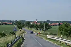 View from the northeast | |
 Flag  Coat of arms | |
 Ladná Location in the Czech Republic | |
| Coordinates: 48°48′20″N 16°52′20″E | |
| Country | |
| Region | South Moravian |
| District | Břeclav |
| First mentioned | 1270 |
| Area | |
| • Total | 10.06 km2 (3.88 sq mi) |
| Elevation | 160 m (520 ft) |
| Population (2020-01-01[1]) | |
| • Total | 1,231 |
| • Density | 120/km2 (320/sq mi) |
| Time zone | UTC+1 (CET) |
| • Summer (DST) | UTC+2 (CEST) |
| Postal code | 691 46 |
| Website | www |
Ladná lies approximately 6 kilometres (4 mi) north of Břeclav, 48 km (30 mi) south-east of Brno, and 228 km (142 mi) south-east of Prague.

Church of Saint Michael the Archangel
References
- "Population of Municipalities – 1 January 2020". Czech Statistical Office. 2020-04-30.
| Authority control |
|
|---|
This article is issued from Wikipedia. The text is licensed under Creative Commons - Attribution - Sharealike. Additional terms may apply for the media files.